Table of Contents
Executive Summary
Introduction
Background
Findings
Policy Implications
Conclusion
Appendix A: Glossary
Appendix B: Raw Data for 49 States (1982-1997)
Appendix C: Percent Change in Land Developed and Sprawl Factors for 49 States (1982-1997)
Appendix D: Calculating Per Capita Land Consumption
Appendix E: The Holdren Apportioning Method
Appendix F: About the Census Bureau's Urbanized Areas
Executive Summary
To date, almost all efforts to combat sprawl have focused on Smart Growth strategies, which primarily seek to create denser settlement by changing land use practices. Our findings indicate this approach will have limited success in saving rural land from development because it fails to address a key reason for sprawl population growth. Our calculations show that about half the loss of rural land in recent decades is attributable to increases in the U.S. population, while changes in land use account for the other half. New immigration and births to immigrants now account for more than three-fourths of U.S. population growth. Therefore, population growth and the immigration policies that drive it must be an integral focus of efforts to preserve rural land.
As opposed to the Smart Growth approach, this study takes a conservationist approach, examining only the loss of rural land to new development and not the quality of urban planning. We focus on state increases in developed land between 1982 and 1997. We also analyze the expansion of urbanized land in the nation's 100 largest cities between 1970 and 1990.
At the most basic level, there can only be three reasons for sprawl: either there is a rise in per capita land use, a rise in the population, or a rise in both. Quantifying the relative role of population growth is important because almost all anti-sprawl organizations have focused on Smart Growth and have generally been dismissive of population growth's role. These groups are not alone. A New York Times editorial in 2000 called it absurd to suggest that population growth and the immigration that drives it contribute significantly to sprawl. Our findings indicate that this view is incorrect.
Among the study's findings:
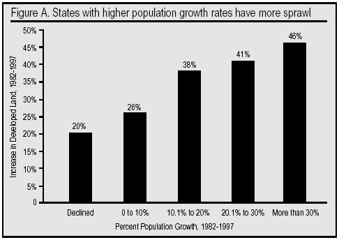
- The more a state's population grew, the more the state sprawled (see Figure A). For example, states that grew in population by more than 30 percent between 1982 and 1997 sprawled 46 percent on average. In contrast, states that grew in population by less than 10 percent sprawled only 26 percent on average.
- On average, each 10,000-person increase in state population resulted in 1,600 acres of undeveloped rural land being developed, even controlling for other factors such as changes in population density.
- Apportioning the share of sprawl that is due to increases in population versus increases in per-capita land consumption shows that, nationally, population growth accounted for 52 percent of the loss of rural land between 1982 and 1997, while increases in per-capita land consumption accounted for 48 percent.
- While population growth is a key factor driving sprawl, our findings indicate that Smart Growth must also play a significant role in anti-sprawl efforts because per-capita land use has been increasing. Between 1982 and 1997, land use per person rose 16 percent from 0.32 acres to 0.37 acres.
- There is significant variation between states in the factors accounting for sprawl. For example, population growth accounted for more than half of sprawl in five of the 10 states that lost the most land, while increases in per-capita land use accounted for more than half of sprawl in the other five worst sprawling states.
- An examination of the nation's largest urban areas reveals the same pattern as in the states. Between 1970 and 1990, population growth accounted for slightly more than half of the expansion of urbanized land in the nation's 100 largest cities.
- In the 1990s, new immigration and immigrant fertility accounted for most of the 33-million increase in the U.S. population. Census Bureau data from 2002 indicate that the more than 1.5 million legal and illegal immigrants who settle in the country each year along with 750,000 yearly births to immigrants are equal to 87 percent of the annual increase in the U.S. population.
- Contrary to the common perception, about half the country's immigrants now live in the nation's suburbs. The pull of the suburbs is even greater in the second generation. Of the children of immigrants who have settled down and purchased a home, only 24 percent have done so in the nation's central cities.
- The suburbanization of immigrants and their children is a welcomed sign of integration. But it also means that they contribute to sprawl just like other Americans.
In short, Smart Growth efforts to slow or stop the increase in per capita land use are being negated by population growth. Immigration-driven population growth, in effect, is out-smarting Smart Growth initiatives by forcing continued rural land destruction.
What makes this study different from most of the research on sprawl is its focus on the destruction of undeveloped rural land. While concern over the loss of rural land is one of the central issues driving the public's desire to reduce sprawl, most studies in this field and most anti-sprawl organizations have not focused on this problem. Instead, they have evaluated the density of new development or the employment of various urban planning techniques. This is true even of organizations and researchers with an environmental orientation. While such studies are valid for analyzing various aspects of sprawl, they fail as measures for conservation goals; their approach has the distinct disadvantage of making the actual loss of agricultural land and natural habitat largely irrelevant because all of the emphasis is on the quality of the planning or the density in the new development. By examining the actual loss of undeveloped rural land, this study avoids this problem.
Why Americans Hate Sprawl
Sprawl was once something that only a few environmentalists worried about, but in recent years it has become one of the hottest topics in local, state, and national politics. Americans are increasingly concerned about worsening traffic, longer commutes, the loss of open spaces near residential areas, increasing congestion, and the environmental impact of ever-expanding development. Such concerns seem justified as, between just 1982 and 1997, America converted approximately 25 million acres (39,000 square miles) of rural land forests, rangeland, pastures, cropland, and wetlands to developed land: that is, subdivisions, freeways, factories, strip malls, airports, and the like. If losses on such an enormous scale are allowed to continue, it seems very likely that sprawl will continue to be an increasingly important political concern into the foreseeable future.
Data Sources and Analysis
Data Sources. This study relies on two sources of data to measure sprawl. The Natural Resources Conservation Service (NRCS), which is part of the U.S. Department of Agriculture, conducts complete inventories every five years of the nation's non-federal land in every state but Alaska. Developed land is defined as any built-up tract of land of at least 0.25 acres or transportation infrastructure, such as roads and railroads, outside of these built-up areas. Although we focus on the NRCS data, we also perform a separate analysis on the expansion of urbanized area in the nation's 100 largest urban areas between 1970 and 1990. The Census Bureau defines urbanized land as contiguous populated areas, including a city's urban core and its suburbs, with a population density of more than 1,000 per square mile.
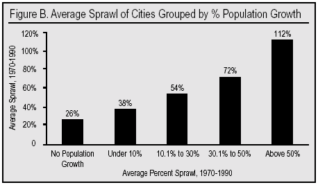
Analysis of Data. We first employed a variety of descriptive statistics comparing the amount of sprawl in the states and cities that grew the most and least in population. If population growth did not contribute significantly to sprawl, as some have contended, then we would expect there to be no correlation between increases in population and sprawl. This study, however, indicates a strong relationship between the two (see Figures A and B). We also employed a linear regression model on the state data where sprawl is the dependent variable, with population growth, changes in population density, and other factors as the independent variables. Finally, we utilize the Holdren Method developed by Harvard physicist John Holdren to apportion the share of sprawl that is due to increases in per-capita land use versus population growth. The Holdren formula is commonly used in environmental science to examine increases in the use of different resources. In the case of sprawl, the resource in question is land.
Policy Implications
Our findings show clearly that both land use practices and population growth must be addressed for any solution to the problem of sprawl. We focus on population growth because so little attention has been paid to this problem. Not surprisingly, in a country with a fertility rate just below replacement level for three decades, U.S. population growth has little to do with native birthrates. That leaves the solution to high population growth resting almost entirely on changing immigration policies. Fortunately, immigration policies can be changed relatively easily in comparison to any attempt to lower birthrates.
At present, around 1.5 million immigrants (legal and illegal) are allowed to settle in the United States each year. Reducing immigration to its historic average of 200,000 to 300,000 a year could dramatically slow the rate of population growth in the United States. A bipartisan national commission chaired by the late Barbara Jordan in the mid-1990s suggested many cuts that would achieve lower numbers. A presidential commission on sustainable development chaired by former Sen. Tim Wirth during the same time period also called for immigration reductions as essential for environmental protection. These commissions commented that making an argument for less immigration is not anti-immigrant, but rather is simply common sense if one wishes to meet certain societal objectives in this case, the objective of reducing the rate of sprawl.
Of course, reducing immigration and the resulting population growth is only part of the solution. Our results clearly indicate that changes in land use patterns account for about half of sprawl. Thus, both Smart Growth efforts and immigration policy changes are integral parts of efforts to combat sprawl.
Conclusion
This study emphasizes the role of population growth because most anti-sprawl efforts ignore it while focusing only on the urban planning approach embodied by Smart Growth. To the extent that population is discussed in the context of sprawl it has generally been dismissed as a cause. It is often argued, for example, that since sprawl occurs where there is no population growth, increases in population must be a minor factor in sprawl. As a moment's reflection should reveal, such observations only make sense in reaction to an assertion that population growth is the only factor generating sprawl. We make no such assertion. Our findings show that population growth is a key factor, but it is by no means the only factor. There are certainly individual places where population growth played little or no role in sprawl, just as there are places where population growth accounted for all of sprawl. But, overall, our analysis shows that increases in population nationally accounted for about half the loss of undeveloped rural land. Thus reducing population growth by reducing immigration must become an important part of any long-term effort to save rural land.
Our conclusion that population growth accounts for half of sprawl is not only consistent with the available evidence, it is also consistent with common sense. Those most directly involved in sprawl certainly believe that population is one of main reasons for sprawl. In fact, the president of the National Association of Home Builders chided the Sierra Club for its 1999 sprawl report because it failed to acknowledge the significant underlying forces driving growth in suburban America a rapidly increasing population and consumer preferences. Homebuilders and real estate developers are clearly pleased with the high rate of U.S. population growth. But they, of course, have a very different point of view from anti-sprawl organizations as well as most Americans.
Assuming population growth continues to drive about half of all sprawl, as it has in recent decades, federal immigration policy would appear to be the single largest factor in determining how much sprawl will occur over the next 50-100 years. Population growth can only be dealt with effectively on a national scale by reducing immigration because new immigration and births to immigrants now account for most of the increase in the U.S. population. Given the population pressure America faces as a result of immigration, local efforts to discourage population growth by, say, low-density zoning, will almost certainly result in leapfrog development and legal challenges. Moreover, intensified Smart Growth programs in the face of rapid population growth will require increased governmental regulation which, in turn, will almost certainly undermine political support for such programs. Absent population growth, Smart Growth policies would be more successful and would encounter less opposition.
While our conclusions may seem obvious to most readers, some may find them controversial. Part of the reason most anti-sprawl organizations ignore population growth is that they are unaware of its role. It is our hope that this study will help correct this. However, some involved in anti-sprawl efforts avoid dealing with population growth because they know that doing so will inevitably lead to a debate over U.S. immigration policy, making it seem as if immigrants are being blamed for sprawl. This is something that anti-sprawl organizations (and the authors of this report) understandably wish to avoid. But such concerns seem misplaced since anti-sprawl organizations can make clear that immigration must be reduced due to rapid population increase rather than because of the characteristics of immigrants. It might also be helpful for such organizations to indicate their support for policies designed to help legal immigrants already here integrate into American society. Moreover, advocating less immigration in the future for conservationist reasons is likely to be politically popular given that public opinion polls show most Americans, including minorities, want less immigration.
While significantly reducing immigration may be very helpful in reducing sprawl, some may worry that doing so might harm the economy. The available data suggest otherwise, however. A 1997 report by the National Academy of Sciences entitled The New Americans concluded that the net economic benefits from immigration are very small and are, in fact, entirely outweighed by the fiscal drain immigrants impose on taxpayers. The nation's leading immigration economist, George Borjas of Harvard, comes to much the same conclusion in his recent book Heaven's Door. Policymakers can reduce future immigration secure in the knowledge that doing so will not harm America's economy.
At present, about 11 million people are allowed to settle legally in the United States each decade. Bringing this number down to three million, coupled with increased efforts to reduce illegal immigration, still would allow the United States to accept more immigrants than any other country in the world. One may favor high immigration for any number of reasons, but our study makes clear that those concerned about sprawl must at least understand that dramatically increasing the size of the U.S. population though immigration has enormous long-term implications for the preservation of rural land. It is very difficult to see how it could be otherwise.
Introduction: Why This Study Is Necessary
Findings of this study vary markedly from other recent sprawl studies. Unlike most sprawl studies that have measured for population density or urban planning techniques, this study keeps its eye on the loss of rural land that is, the development that destroys natural habitat and agricultural land, especially denying the rewards of open space near where most Americans live.
While past studies on density and urban planning are important to understanding sprawl, they have left a gaping hole in knowledge about the conservationist aspect of sprawl. Thus, this study is the first to shine the spotlight on the actual loss of rural land as the result of sprawl and on the relative importance of major factors contributing to that loss.
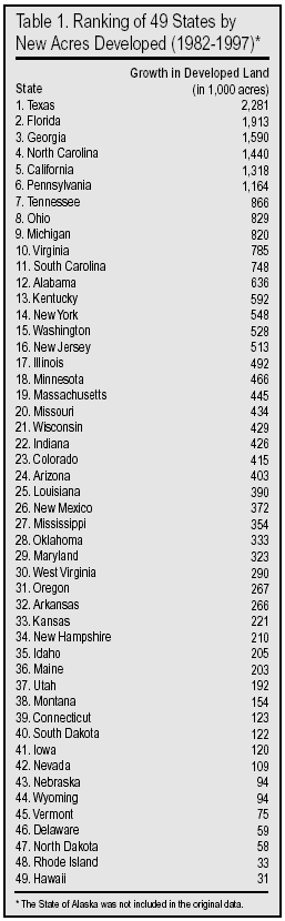
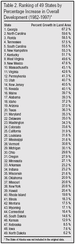
Table 1 ranks 49 states (excluding Alaska) according to where the most destruction of rural land has occurred between1982 and 1997. Table 2 ranks the states according to the greatest percentage increase in developed land. In terms of the anti-sprawl goal of protecting rural land, the two charts provide the best measure of which states are doing the best job (those at the bottom of the list) and which are the greatest failures (those at the top of the list).
Conservation Focus Draws Attention to Population Growth
The major conclusion of this conservation-oriented study is that sprawl is strongly linked to U.S. population growth and cannot be tamed in a practical manner unless population growth is substantially slowed or halted.
To many Americans, that conclusion is unremarkable. After all, those new subdivisions, industrial parks, and strip malls sprouting up like crabgrass across the country are not being built on a whim but rather to provide housing, places to work, and marketplaces for more and more people; around 33 million more were added to the U.S. in the 1990s alone.1
However, our major conclusion is likely to be controversial among policy analysts and policy makers who have largely ignored sprawl's connection to this country's current, largest-ever population boom. The authors began this study after a literature survey found that although anti-sprawlers nationwide propose dozens of solutions to sprawl, virtually none of them include any reference to slowing population growth. Many never even mention the concept of population growth as they describe the devastation of sprawl, enumerate its causes, and propose vast public policy agendas to slow the development and urbanization of rural land and open spaces.
On the infrequent occasion population growth has been cited in sprawl studies, it usually is in the context of minimizing the effect of population growth. Most commonly, population growth is dismissed as being unimportant because (1) sprawl occurs even in urban areas that have no population growth or (2) the rate of sprawl is far greater than the rate of population growth in most areas. Both are true. But neither contradicts this study's finding that population growth nationally is related to approximately half of all rural land that is lost to development.
The Missing Factor
Population growth as a sprawl factor is particularly ignored by the Smart Growth movement, a loose, eclectic coalition of environmentalists, local growth-control activists, New Urbanists, municipal and regional planners, think tanks, the federal government and many state governments, and even some home-builders and developers.
For example, neither the website of the American Planning Commissioners Journal nor the Vermont Forum on Sprawl identifies population growth as a source of sprawl, let alone mentions taming it as one of sprawl's solutions. A long article entitled Stemming the Tide of Sprawl in the February, 1999 issue of The Chronicle of Philanthropy described the growing support for combating sprawl on the part of a number of large foundations; it omitted any mention of stemming the tide of population growth. Similarly, in the 90-page, 1998 publication How Smart Growth Can Stop Sprawl by David Bollier for the anti-sprawl group Sprawl Watch Clearinghouse, the words population growth never appear. A four-page letter and two-page survey on sprawl and disappearing farmland included in a recent direct mail campaign by the American Farmland Trust failed to mention population growth once.
In a major report on sprawl issued in 2000, the National Governors Association at least mentioned population, but only to minimize its influence: The development of suburban land since 1960 has far outpaced population growth in every region of the country. An urban policy expert at Rutgers University, a well-known and well-regarded center of scholarly research on sprawl, did mention population growth in comments to The Washington Post, but only to slight its contribution to sprawl. A spokesman for the leading anti-sprawl group in the Washington, D.C. area, Smart Growth America, denied that population growth and immigration in the region bore any responsibility for sprawl.
A stark demonstration of all this was evident at the 1998 annual conference of the Society of Environmental Journalists in Chattanooga. Sprawl was a top issue throughout the conference. One of the most popular workshops was on the coverage of sprawl issues. Several reporters described their newspapers intensive efforts in this area. When an audience member asked why none of them had mentioned any coverage of the role of population growth in sprawl, all the reporters on the panel acknowledged that population growth was a major factor in sprawl. But, they said, they didn't write about it because it wasn't something that public policy could affect. The same sort of fatalism pervades the National Governors Association report mentioned above, which lumps controlling population growth in with reducing economic growth and controlling family preferences as impractical solutions to sprawl.
In the back of the room at the Chattanooga sprawl workshop, the Sierra Club had a display table devoted to its massive campaign against sprawl. But the Sierra sprawl publications did not mention U.S. population growth as contributing to sprawl. For example, Suburban Sprawl Costs Us All does not include support for population growth reduction among its list of steps to stop sprawl. Likewise, the Club's report The Dark Side of the American Dream does not list slowing population growth among its Smart Growth Solutions. More recently, under pressure from dissident members like those of Sierrans for U.S. Population Stabilization (SUSPS), the Club's anti-sprawl campaign materials have belatedly recognized that population growth is an ingredient of sprawl, but still insist that other factors are far more important.
A number of writers for environmental publications have told this study's authors about taboos against addressing population connections to sprawl. Politicians have imitated the media and Smart Growth advocates as they have taken up the anti-sprawl cause. In January of 1999, 27 governors 19 Republicans and eight Democrats referred to Smart Growth in their state-of-the-state speeches. Not one noted federal policies that cause high U.S. population growth.
In light of all of that, this study's conclusion that population growth is the single greatest factor in this nation's struggles with sprawl is boldly out of step with most public comments of anti-sprawl groups and experts.
So what is going on here? Is it really true as the anti-sprawl movement's silence on the subject seems to suggest that adding more than three million people to the United States each year is not a significant factor in sprawl? Or has an entire movement somehow missed one of the most important solutions to the problem it is trying to confront?
Other Studies Address Different Sprawl Goals
An explanation as to why most other studies fail to find the population/sprawl connections discovered here is that their analyses use fundamentally different measuring tools with different goals in mind.
Like many mass political and social movements, the anti-sprawl effort combines several impulses under one banner. Even the term sprawl, as will be discussed in the Background section, has many definitions. Anti-sprawlers are not at all united in their goals. Some primarily work for more attractive or more energy-efficient urban planning. Others concentrate on increasing residential density, while still others focus mainly on saving rural land from urbanization and other development. These different branches of the anti-sprawl movement may be outlined like this:
Conservation category
1. Land Conservation Branch
The conservation of rural land is the key measure of success and is the focus of sprawl studies among this branch of anti-sprawlers.
Smart Growth category (divided into two branches)
2. Density Branch
Increasing the density of residents is the key measure of success for this branch and is the focus of its sprawl studies.
3. Urban Planning Branch
Better urban planning is the key measure of success for this branch and is the focus of its sprawl studies. Increasing density is not a primary goal.
The three branches of the anti-sprawl movement are not mutually exclusive. Each one contains some elements of the other two and, for the most part, they are not working at cross purposes. But because each has different goals and measures for success, it should not be surprising that studies from the perspective of one branch would not be sufficient for another branch.
Most in the Density and Urban Planning branches of the Smart Growth category are not opposed to conserving rural land. But neither are they primarily concerned with reducing the spread of cities over nearby open spaces, natural recreational places, farmland, wetlands, woodlands, and other bird and animal habitats. Because of that, most in these two branches are relatively unconcerned about the current pace of U.S. population growth, which the Census Bureau projects will add more than 130 million people over the next 50 years (nearly 300 million more by the end of the century).2
Population growth actually can help the goals of the two Smart Growth branches. A recent Brookings study found population density generally increases when the population of an area is growing rapidly.3 If one's chief goal is to increase the density in which Americans live, rapid population growth can be very helpful. Likewise, additional population growth can help urban planners carry out desired projects by providing more consumers and residents to share the costs of renovation, or for in-filling to make desired transportation projects more feasible.
But population growth almost never has a positive impact on the conservation goal of protecting rural land. Thus, on the issue of population growth, the two categories of the anti-sprawl movement appear to be at odds.
Furthermore, the way that the Density and Urban Planning branches measure sprawl often leaves out any concern for preserving actual acreage of rural land:
Density branch: Using population density as a chief measure of the success of anti- sprawl efforts can lead to results that have no connection to the conservation of rural land. One example is a major study conducted and published by USA Today in 2001.4 It focused on density and defined sprawl as straggling, disorderly, haphazard growth. Like many studies and reports from the Density branch, it did not label the destruction of rural land as sprawl if the new development was densely populated. The newspaper created a USA Today Sprawl Index to rank cities by how densely developed a metro area is today, and how that changed during the 90s. By stressing density, it could hold up Los Angeles as a pretty good model. Even though the Los Angeles urbanized area expanded to cover another 394 square miles of natural habitat and agricultural land from 1970 to 1990, it could be considered not so sprawling after all, because the residents of the area were living more densely.
Urban Planning branch: Although plenty of urban planners are concerned about increasing population density, the main concern of this branch is to have more attractive and more energy-efficient development. Eben Fodor, author and community planning consultant, notes: Smart Growth is simply a more orderly and less chaotic process of land development. It may or may not involve greater density and therefore greater efficiency in land use. For example, a great deal of Smart Growth is focused on having growth occur near existing services to reduce costs to taxpayers. This alone doesn't reduce per-capita land consumption to any significant degree. In the worst-case scenario, Smart Growth is merely the planned, orderly destruction of our remaining natural environment.5 One part of the Urban Planning branch is dominated by developers, builders, and real estate people who want to bring higher standards to their industries. Far from wanting to preserve rural land, they strongly favor its development. They simply want the transformation of rural to urban to occur in tasteful, well-planned ways. Another part of the Urban Planning branch is more neutral about destroying rural land, reflected in the statement of the head of Smart Growth America about that national group's 2002 study of sprawl: the study does not look at the rate of land consumption the conversion of rural land to suburban subdivision.6
Smart Growth America is a nationwide coalition of over 80 national and regional business, government, and environmental organizations. Its study and general approach to sprawl reveals the main reason until now that the need to reduce population growth to control sprawl has been missing from the debate: Most sprawl studies have defined sprawl in such a way as to exclude population growth as a factor. The Smart Growth America study ranked sprawl in metropolitan areas based on four factors:
(1) residential density;
(2) strength of activity centers and downtown areas;
(3) the mix of home, jobs and services; and
(4) accessibility of street networks.
Actual loss of rural land was not considered. And what was the definition of sprawl? Sprawl is the process in which the spread of development across the landscape outpaces population growth. Thus, any rural land that is destroyed at the same rate of population growth is not sprawl under the non-conservationist approach to sprawl. If our population grew by 50 percent, and the additional 145 million Americans caused the developed area to expand by 50 percent over 49 million additional acres, none of that would be sprawl under the Smart Growth America study's definition.
Looking at Sprawl with a Concern for Protecting Rural Land
Clearly, the definitions and measurements of sprawl vary because of the differing goals of those doing the measuring. Because of that, it is easy to misinterpret results of studies that operate in different contexts. If one is interested in reducing ugly, inefficient developmental sprawl, the Urban Planning branch studies will be of most assistance. If one is interested in increasing the density at which Americans live, the Density branch of the Smart Growth movement will have the most helpful studies.
But if one is interested in slowing the destruction of natural habitat and farmland by developmental forces, studies from the Urban Planning and Density branches will be of limited help. Instead, one needs to look at conservation-oriented studies that focus on the actual loss of rural land.
This is just such a conservation study. It does not define away any destruction of rural land. No matter what the cause of the destruction, this study considers it to be sprawl to be measured. The authors began with the hypothesis that adding large numbers of new residents to a state is a significant factor in the development of additional rural land. The purpose of the study was to find an objective way to test that hypothesis. The authors worked with scholars and experts around the country to devise a credible means of measuring the impact of population growth on the development of open spaces, relying entirely on governmental surveys of rural land loss and time-tested mathematical analysis. (The methodology is presented in Appendices D and E of this report.)
The findings are unambiguous: Population growth not only is a significant factor in sprawl but is roughly equal to all other factors combined. Massive population growth may sometimes be helpful to Smart Growth goals of density and better urban planning, but it is a profoundly negative factor in trying to stop the spread of cities over the countryside.
The general principles behind the findings are not without some prior support. That is, our series of studies (including earlier ones on California and Florida urbanized areas) may be the first to attempt to systematically quantify the role of population growth in sprawl, but the general principle that population growth is related to sprawl has been endorsed in many places outside the advocacy pronouncements of the Smart Growth groups and politicians.
The U.S. General Accounting Office in 1999 issued a study on sprawl and noted that suburban growth began in response to a number of social, economic, demographic and technological factors, including the postwar population boom.7 As one might expect, the population control organization Population Connection (formally, Zero Population Growth) also sees a strong connection: The driving force behind sprawl is population growth.8 In the last few years, a number of Sierra Club chapters passed resolutions urging their national organization to incorporate U.S. population stabilization as an anti-sprawl strategy. Their resolution stated in part: WHEREAS population growth is a major factor in sprawl.9 Club population activists forced the Sierra Board of Directors to hold a national referendum of members early in 2001 on whether to integrate population into the Club's anti-sprawl campaign. Opposed by the national Board of Directors as micromanaging the Club's staff, the referendum was narrowly defeated 54 percent to 46 percent.
Developers Recognize Role of Population. Especially forthright in recognizing the connection between population growth and the urbanization of rural land are homebuilders and land developers. Growth in population creates a need not only for housing but also for supporting real estate facilities such as shopping centers, service stations, medical clinics, schools, office buildings, and so on, explains one real estate development manual.10 Demand for real estate at the national level is influenced by national population growth and demographic change, coupled with expanding employment opportunities and rising per capita incomes, points out another.11 The president of the National Association of Home Builders chided the Sierra Club for not giving population growth its due in the Club's 1999 sprawl report:
the Sierra Club failed to acknowledge the significant underlying forces driving growth in suburban America a rapidly increasing population and consumer preferences. The U.S. needs to construct between 1.3 and 1.5 million new housing units annually during the next decade simply to accommodate an anticipated 30 million increase in the nation's population.12
The bulk of leaders in the home-building and real estate development industry applaud the development of farmland, natural habitat, and open spaces as a sign of economic prosperity, although many call for new urbanization to occur in a more compact and esthetically pleasing manner. And they are pleased with the high U.S. population growth that drives that development. A demographer from Boston Financial expressed excitement to a packed room of real estate professionals at an October, 1999, Urban Land Institute meeting in Phoenix that Hispanic and Asian immigrants constitute groups that would continue to grow into the biggest consumers of new homes in the U.S. through 2030: Through 2030, as much as 60 percent of the United States population growth will come from new U.S. residents Bolstered by a huge influx of immigrants. That flow of people could create 1.2 million more households each year, which is welcome news for businesses with a product to sell.13
In a recent feature story on a NumbersUSA study titled Weighing Sprawl Factors in Large U.S. Cities, the Home Builders Association of Northern California declared that: Local officials should reject no-growthers sprawl label and OK smart-growth projects needed for an expanding population. And the association's CEO declared that population growth is a fact of life.14
So, those who welcome sprawl have readily acknowledged the connection to population growth, while most leaders who oppose sprawl from the Density and Urban Planning branches of the movement have been silent about it or have greatly minimized its importance.
On the other hand, nothing in this study suggests that the anti-sprawl movement, including its Smart Growth subset, has been wrong in trying to tackle poor planning, inefficient development and a couple of dozen other factors causing an increase in land consumption per person. This study finds that trends toward higher per capita land consumption are responsible for around half of all sprawl. Obviously, the anti-sprawlers are correct to lend their attention to that half of the problem.
But the authors believe that for those leaders and organizations who truly desire a brake on the irrevocable loss of farmland and natural habitats, this study provides powerful new information that will result in their opening up significant additional fronts in their battle against sprawl. Until now, they have been handicapped by the lack of a credible statistical rationale for trying to tame the nation's population growth.
The authors hope that this effort to quantify population's role will serve as a lest we forget reminder that, nationwide:
(1) population growth is a major factor behind sprawl, associated with roughly half of all sprawl nationwide;
(2) that simply ignoring population growth will not make it go away, and;
(3) that unless it is addressed forthrightly, all other efforts to stop sprawl are likely to fall short over the long term. These efforts will only slow sprawl, not stop it. A given stretch of open countryside will take 10 years to fill up instead of just five. Is this good enough? We think not.
Background
Sprawl: Growing into a National Issue
"Long considered a local fringe issue dominated by pie-in-the-sky environmentalists, sprawl is suddenly one of the hottest topics in state and national politics."
-Dan Eggen, The Washington Post, October 28,1998
For several decades, many Americans have felt the disquieting sensation that the wide open spaces and picturesque countryside that helped to forge our national character and still form an integral part of our national and natural endowment are rapidly disappearing under concrete, asphalt, steel, and cinderblock. And for just as long, they have been assured that their fears are unfounded that there is no current or impending shortage of land or resources.15 Reporter Gregg Easterbrook writes "within the boundaries of the United States lies an astonishing vastness of land that has not undergone the concrete conversion experience"16 In his conservation classic The Quiet Crisis, former Secretary of the Interior Stewart Udall referred to this persistent belief on the part of some Americans that our natural resources were all but inexhaustible as the "Myth of Superabundance."17
Yet the perception of swiftly spreading development and rapidly retreating open spaces is rooted in reality. In just the 15 years from 1982 to 1997, America converted approximately 25 million acres (39,000 square miles) of rural land forests, rangeland, pastures, and cropland to developed land, that is, subdivisions, freeways, factories, strip malls, airports, and the like.18 That's an area about equal to Maine and New Hampshire combined. These losses occurred at an average rate of 1.7 million acres per year. And according to the U.S. Natural Resources Conservation Service (NRCS), which has conducted these inventories of the nation's ecologically productive land base every five years since 1982, in the 1990s the rate at which rural land was developed accelerated, rising to about 2.2 million acres per year. These losses are shown in Table 1.
If this rate of 2.2 million acres per year continues to the year 2050 when today's toddlers are middle-aged the United States will have lost an additional 110 million acres of rural countryside. That's 172,000 square miles, about equal to the combined areas of Connecticut, Massachusetts, Rhode Island, Vermont, Delaware, Pennsylvania, New York, New Jersey, and Virginia. Added to the loss of an area equivalent to Maine and New Hampshire from 1982-1997, that amounts to much of the Eastern Seaboard. Anyone who has flown at night from New York to Florida and seen the vast clusters of lights below sweeping away as far as the eye can see knows just how far advanced this process of mass urbanization already is.
Moreover, the measured area of developed or built-up land per se underestimates its actual pervasiveness in the American landscape because urbanized land affects activities and environmental quality on adjacent rural areas by means of water demands, noise, views, odors, air pollution, and water pollution. For example:
- Coal-burning power plants in the Ohio River Valley that supply electricity to tens of millions of consumers in large Eastern cities generate sulfur dioxide emissions that impede visibility in the countryside and then fall to earth as acid rain hundreds of miles away in wilderness areas of the Adirondacks, Canada, and New England. The once densely-forested summit of Mt. Mitchell in North Carolina's Great Smoky Mountains, highest point in eastern North America, has been stripped to skeletal tree remains from being bathed in acid-laced clouds.
- Water quality in the East Coast's most important estuary, the Chesapeake Bay, is threatened by the sheer spread of pavement and other impervious surfaces within its 64,000-square-mile watershed. By 1990, some 11,480 square miles had already been developed, and analysis of satellite imagery and other ground-based data indicates that in the 1990s an additional acre was being developed every six to 10 minutes. Residential and related land development degrades local streams and sends "water-fouling" nutrients (primarily nitrogen and phosphorus compounds) into the bay, which threaten to overwhelm hard-won, costly reductions in these "loadings."19
- Urban growth demands water that, especially in the arid West, must be diverted from farmers. Suburban neighborhoods with lawns and pools are particularly water-consumptive. Of California's 350 water basins, 40 are seriously overdrafted, and by 2020 water planners predict a water supply deficit of two to eight million acre-feet.20
- One of the reasons farmers are forced to quit farming as suburbia encroaches is that livestock odors invariably drift into adjacent subdivisions and cause complaints. Likewise, the pungent smells of factories, pulp mills, and smelters can diffuse across vast areas.
- The sprawl and smog of Los Angeles degrades air quality not only in Joshua Tree National Park and the Mojave Desert 100 miles to the east, but even in Arizona's Grand Canyon, hundreds of miles away.
- More and more around the country, sightseers at local viewpoints must gaze out over clutter where once there had been mostly open landscapes. Hikers in California and Colorado reach summits only to be rewarded with vistas of new subdivisions under construction. Sprawl threatens the bucolic ambience of such national historic treasures as Mt. Vernon and the hallowed Civil War battlefields of Manassas-Bull Run, Antietam, Fredericksburg, and Gettysburg, among others.
- Noise from airports and highways propagates over empty spaces beyond. At Petroglyphs National Monument west of Albuquerque, jets roaring overhead intrude upon the sense of tranquility and the timelessness of mute, centuries-old Indian rock carvings.
Altogether, these influences convey a sense of congestion, heavy human presence, and environmental blight that extends well beyond the immediate confines of the built-up space itself. By way of further example, a study in the February 2000 issue of the journal Conservation Biology estimated that while the four million miles of roads in the United States only cover 1 percent of the country's surface area, they directly affect the ecology of nearly 20 percent of U.S. land by blocking wildlife migration routes, helping spread non-native species, disturbing birds with traffic noise (and reducing their numbers by one-third), channelizing watercourses, and partially draining wetlands.21
Loss of Farmland. The National Resources Inventory estimates that the nation lost 44 million acres of cropland, 12 million acres of pastureland, and 11 million acres of rangeland from 1982 to 1997, for a total loss to our agricultural land base of 67 million acres.22 (One explanation of the much higher acreage of lost cropland than pastureland and rangeland is that a larger fraction of the cropland acreage was not "lost" per se, but deliberately "retired" from active production into the so-called Conservation Reserve Program or CRP, a program administered by the U.S. Department of Agriculture's Farm Service Agency. These were lands of marginal quality and high erodibility, lands on which modern, intensive agriculture is not sustainable.) All 49 states inventoried lost cropland. The impacts of the loss of this land extend beyond agriculture. The USDA has estimated that each person added to the U.S. population requires slightly more than one acre of land for urbanization and highways.23 Clearly, more land is required as more people are added to our population.
A comparison of acreage 25 million acres of newly developed land over this period and 67 million acres of agricultural land lost shows that development is not responsible for all or even half of agricultural land loss. Arable land is also subject to other natural and manmade phenomena such as soil erosion, salinization, and waterlogging that can rob its productivity and eventually force its retirement. Much of these losses are due to over-exploitation by intensive agricultural practices needed to constantly raise agricultural productivity (yield per acre) in order to provide ever more food for America's and the world's growing populations.
Thus, the potent combination of relentless development and land degradation from soil erosion and other factors is reducing America's productive agricultural land base even as the demands on that same land base from a growing population are increasing. If the rates of agricultural land loss that have prevailed in recent years (from 1992-1997, so that the CRP does not bias the results) continue to 2050, the nation will have lost 53 million of its remaining 377 million acres of cropland, or 14 percent of it, even as the U.S. population grows by over 40 percent from 283 million to 420 million.24 Continuing onto 2100, the discrepancy widens even further. The Census Bureau's medium range projection is 571 million, almost a doubling of today's U.S. population. If the same rate of cropland loss were to continue, the United States will lose approximately 106 million acres of its remaining 377 million acres of cropland, or nearly 30 percent. Cropland per capita, that is, the acreage of land to grow grains and other crops for each resident, will have declined from 1.4 acres in 1997 to 0.47 acres in 2100, a 66 percent reduction. If this happens, biotechnology will have to work miracles in raising yields per acre in order to maintain the sort of diet Americans have come to expect.
These ominous, divergent trends an increasing population and declining arable land have led some scientists to think the unthinkable: that one day America may no longer be able to feed herself, let alone to enjoy a food surplus for export to the world. Cornell University agricultural and food scientists David and Marcia Pimentel and Mario Giampietro of the Istituto Nazionale della Nutrizione in Rome have argued that by approximately 2025, the United States will most likely cease to be a food exporter. Food grown in this country will be needed for domestic purposes. And by 2050, the ratio of arable land per capita may have dropped to the point that, "the diet of the average American will, of necessity, include more grains, legumes, tubers, fruits and vegetables, and significantly less animal products."25 While this may in fact constitute a healthier diet, it would also represent a significant loss of choice.
Traffic, Crowding, etc. With the lowest food prices in the world for the present, most Americans have more immediate concerns with sprawl, like worsening traffic, longer commutes, overcrowded schools and other facilities, rising taxes, and the loss of greenery that lends beauty and charm to urban and suburban living. These concerns have made sprawl and how to curb it a hot political issue around the country.26 A February 2000 national survey conducted by Princeton Survey Research Associates for the Pew Center for Civic Journalism found that Americans rated the complex of issues called "Development/Sprawl/Traffic/Roads" along with "Crime/Violence" as the most important local issues in the country today, ahead of such perennial concerns as the economy and education.27 In rapidly growing urban areas such as San Francisco and Denver, sprawl is a "huge" issue, according to the Pew survey. Sprawl figured in 13 state and 226 local ballot initiatives and referenda in the fall of 1998, of which 72 percent were considered victories for the anti-sprawl forces.28 As one newspaper reporter in the northern Virginia suburbs of Washington, D.C. wrote: "Voters across Northern Virginia sent a strong message to their newly elected leaders: They are fed up with their steadily increasing commute times, the clearing of what few trees are left for another house or office building and having to send their children to school in portable trailers."29 In the 2000 elections, voters overwhelmingly approved referenda to fund open space protection, passing 174 of 209 (83 percent) of such ballot questions.30
Politicians of both political parties have recognized that they stand to win or lose elections based on how voters perceive how serious they are in standing up to sprawl. Until he turned his attention to his presidential candidacy, former vice president Al Gore was the most prominent politician on the national stage who made sprawl, and its reputed solution, "Smart Growth," a centerpiece of his message.31 But a number of Democrats and Republicans alike at the state and local levels, like former Maryland Governor Paris Glendening and former New Jersey Governor turned EPA Administrator Christie Todd Whitman, have made political hay with efforts to tame sprawl.32 In January 1999, 27 governors 19 Republicans and eight Democrats discussed Smart Growth in their state-of-the-state speeches.33 The Sierra Club, the National Trust for Historic Preservation, and the free-market, libertarian think-tank the Cato Institute each tout their own interpretations and solutions to the problem. Others are less willing to grant that there is even a problem. The Sprawl Watch Clearinghouse claims that opposition to anti-sprawl initiatives comes from "a small number of vocal critics affiliated with property rights organizations, free market think tanks, and home builder and development interests."34
The authoritative government statistics above on increases in developed land and declines in agricultural land should put to rest any uncertainty as to whether a significant shift in land use is underway in America. The U.S. Census Bureau's decennial reports on Urbanized Land also show dramatic increases in the physical area of many towns and cities.
This study will show how these increases in urbanized or developed land that is, "sprawl" can be mathematically divided into two factors: population growth and increases in land used per capita (or declining density), the second of which is comprised of 20 or more sub-factors.
"Sprawl" Defined and Measured
After the suffering and sacrifice of the Great Depression and the tragedy and triumph of World War II, the United States embarked on an era of good times an era that has now endured with only minor slowdowns for more than half a century. An unprecedented economic and population boom has raised aggregate natural resource consumption and waste generation to levels without parallel in this nation's or any nation's history. This dramatic expansion in American enterprise led to a number of adverse environmental side-effects, or "externalities" in the economists parlance. Two one-syllable words in particular smog and sprawl joined America's popular vocabulary in the post-World War II epoch to describe a set of undesirable side-effects that spectacular affluence and population growth left in their wake.
Like "smog," which entered the nation's lexicon as a convenient, if imprecise, term for a complex phenomenon one type of air pollution the word "sprawl" has emerged in recent decades as shorthand for the relentless spread of cities and their suburbs. Five features of sprawl are emphasized by many of its definers:
- progressive loss of open space at urban perimeters as an urban area grows and spreads into the surrounding countryside;
- low-density character, in contrast to compact urban cores;
- chaotic, or unplanned nature;
- dependence on the automobile; and
- connection with the decay of inner cities.
This study uses a readily quantifiable measure of sprawl the conversion of open space or rural land to built-up, developed, or urbanized land over time. The advantage of this straightforward measure is that it acknowledges the successive, cumulative loss of agricultural lands and natural habitat to spreading urbanization, regardless of the density of that development.
Measuring sprawl in this way implicitly incorporates the density factor. The lower the average population density, the greater the amount of land developed. If the population of a given urban area grows by 25 percent over a given 20-year period, and the amount of land per resident also grows by 25 percent, then the city will have sprawled 56.25 percent over that period. If, however, the population does not grow at all but the amount of land per resident increases by 25 percent, then the total increase in land area of the city will be exactly 25 percent. Alternatively, if the land area per resident remains constant, and the population increases by 25 percent, then the total increase in land area is also 25 percent.
Thus it can be seen that if sprawl is measured as increasing urbanized or developed land area, then at any given population size:
- Less land per person (higher density) = less overall land consumption (sprawl)
- More land per person (lower density) = more overall land consumption (sprawl)
These concepts and how sprawl is mathematically apportioned between its population and density shares are explained more fully under the section of this report titled Findings, and in Appendices D and E.
Using land consumption to measure sprawl also enables use of extensive data compiled by two federal agencies that catalogue land use at regular intervals: the U.S. Department of Agriculture's Natural Resources Conservation Service inventories (NRI, or National Resources Inventory) of "developed land" every five years, from 1982 to 1997, and the U.S. Census Bureau's delineations of "urbanized land area" every decade since 1950.
Nearly every organization and most researchers that address sprawl rely on either the Urbanized Area data or the NRI data as the foundation of any quantification of total sprawl. What they haven't done is use those same data to quantify the relative roles of population growth and per capita land consumption in generating that sprawl. Yet it is possible to measure sprawl from half-decade to multi-decade intervals by noting the change in overall acreage of a specific urbanized area or developed land within a given state.
Quantity or Quality? It is instructive to compare our quantitative measure of sprawl with the more qualitative concepts promoted by other prominent definers of the term. Former vice president Al Gore, in a December 1998 speech to the Democratic Leadership Council Annual Conference, painted a vivid "panorama" of sprawl as: "the chaotic, ill-planned development that makes it impossible for neighbors to greet one another on a sidewalk, makes us use up a quart of gasoline to buy a quart of milk, and makes it hard for kids to walk to school"35 The Sierra Club, in its 1998 report The Dark Side of the American Dream, defined sprawl as "low-density development beyond the edge of service and employment, which separates where people live from where they shop, work, recreate, and educate thus requiring cars to move between zones."36 The American Farmland Trust has characterized urban sprawl as "low density development that spreads out from cities, leaving the core hollowed out and in decline, while wastefully consuming some of America's most productive farmland."37 And the president of the National Trust for Historic Preservation said, "sprawl is the poorly planned, low-density, auto-oriented development that spreads out from the edges of communities."38
As stated above, the measure of sprawl used in this study implicitly incorporates the concerns about density expressed by these individuals and groups.
But most recent studies and reports on sprawl, while measuring density, have neglected the actual amount of lost rural land, even dismissing some urbanization of rural land as not constituting sprawl. For example, the 1999 publication Covering Urban Sprawl: Rethinking the American Dream weighs in that "Sprawl is associated with rapid suburban growth, but not all growth is sprawl. It's a pattern of development that puts miles of asphalt between home and work, work and school, shops and home, Mom and the soccer-plex and connects them with the automobile. Sprawl is occurring when, as in most metro areas, suburban expansion consumes land at a faster rate than population grows, even as central cities and inner suburbs decline."39 In like fashion, the 2001 Brookings study on "who sprawls most" specifically excluded those extended cities in which the rate of population growth outpaced the rate of land development or urbanization. By this peculiar definition, greater Los Angeles, which expanded across nearly 400 square miles of undeveloped land from 1970 to 1990, did not sprawl at all, simply because it was growing denser (from population growth) at the same time. On the contrary, a common-sense understanding of sprawl recognizes that land-devouring sprawl can be either low-density or high-density.
Some anti-sprawl activists and organizations further emphasize the density dimension by using the term "suburban sprawl" in place of merely "sprawl" or "urban sprawl," which was the term of choice in the 1960s and 1970s. The principal flaw in defining sprawl as only low-density, unplanned, or auto-dependent is that even if new development were as high-density, well-planned, and mass transit-friendly as urban cores themselves or as Smart Growth supporters advocate, considerable amounts of land would still be consumed every year by expanding cities and towns. For instance, if all of the Atlanta Urbanized Area's 1970-1990 population growth had been accommodated at the same density as that city's 1970 urban core (rather than at the lower suburban densities at which it actually occurred), this would still have covered 166,820 acres (261 square miles) of rural land. Much new residential development is taking place at higher densities than 20 years ago witness the veritable explosion of townhouses, rowhouses, condominiums, and apartments but substantial new quantities of rural land are still being urbanized.
If the term "sprawl" is to be meaningful, it must account for this loss of open space, whether to high or low-density development.40
In sum, sprawl can be measured for both quality and quantity. This national-level study of sprawl, however, limits itself to quantification measuring the amount of urban sprawl.
We use the term "overall sprawl" to refer to the increase of the total size of developed land. Overall sprawl is the loss of rural land at the periphery of a city or development in rural areas. This involves the conversion of open space or rural land into built-up, developed, or urbanized land over time, whatever the quality of that conversion.
We believe this measurement by amount most closely resembles the most common American understanding of sprawl. If 25 square miles of open spaces around a city are urbanized, most Americans would consider that to be 25 square miles of sprawl, regardless of whether it was developed tastefully or not. They might be more offended by the sprawl if it included ugly or garish development, but the amount of sprawl and the number of rural acres lost would be the same. Thus, using this measure, it is possible to have well-planned sprawl or chaotic sprawl, to have high-density or low-density sprawl, to have auto-dependent or mass-transit-oriented sprawl. But regardless of the quality of the sprawl, the bottom line is that the amount of sprawl is measured by the square miles of rural land converted by development into built-up, urban land.
The quantity of sprawl is of great importance to environmental and agricultural considerations. But it also is significant in the quality of life of urban dwellers. The larger an urban area, the more difficult it will be for the average resident to reach the open spaces beyond the urban perimeter; increasing urban distances can also affect commuting time, mobility, and a resident's feeling of being "trapped." The vaster the city, the greater one's sense of estrangement from nature and the greater the illusion that the world was built by and for humankind alone.
Why Americans Don't Like Sprawl
In recent years, on top of the loss of natural habitats and farmland documented in the introduction, sprawl has been blamed for a wide array of societal maladies ranging from urban decay and suburban alienation to increased taxes and flooding. Surveying the colorful but overheated rhetoric of sprawl's harshest critics, one could be excused for thinking they regard the freedom of millions of individual homebuyers to settle into detached houses with yards in the suburbs as no more wholesome than the freedom of millions of cigarette smokers to court lung cancer and emphysema: An "unrelenting pathogen sucking the marrow from our cities and towns;" "A strange collection of objects flung across the landscape;" "It creates the conditions for social decay and behavioral pathology." According to the National Trust for Historic Preservation report Challenging Sprawl: Organizational Responses to a National Problem, these quotes come from a businessman, a real estate developer and a clinical psychologist.41
The most strident anti-sprawl activists argue passionately that the country desperately needs to awaken from the American Dream before it produces nightmarish consequences. Impassioned denunciations aside, however, sprawl does indeed entail a number of environmental, economic, and social effects, which are mentioned in turn below. For the most part, we do not treat these exhaustively because there is a burgeoning popular and scholarly literature on the consequences real and alleged of sprawl.
Environmental Effects
Conversion of Farmland, Natural Habitats, and Open Space. This ongoing, accelerating loss of undeveloped countryside around the fringes of cities and towns is perhaps the greatest direct effect of urban and suburban growth, and the one that causes the greatest consternation. The Madison, Wis., based Biodiversity Project, for example, has identified sprawl as a top concern: "human settlements are nibbling at the edges of what was once productive habitat. Roads are carving up the core areas and cutting off the natural corridors. In some cases, new development simply swallows up the natural landscape, and malls and houses stand where there were once productive fields and forests. Poorly controlled development sprawl is a primary cause of habitat loss."42
The loss of suitable natural habitat is perhaps the main threat to endangered species and biodiversity in the United States. Habitat loss generally, though not always, accompanies conversion from rural to urban land, depending on the intensity of development and the particular habitat needs of a given species. A report by the National Wildlife Federation found sprawl and associated habitat loss to be the leading cause of species imperilment in California the state with the greatest richness (after Hawaii) of endemic species (those which occur nowhere else). Sprawl is responsible at least in part for the precarious state of 188 of the 286 species of plants and animals listed by the federal government as threatened or endangered in California.43 Thus, sprawl has helped turn the state into one of the Earth's "biodiversity hotspots." That is, comparatively speaking, a very high fraction of the state's unique and endemic plant and animal species and the living communities and ecosystems they comprise are jeopardized by human activity and development associated with Californians vast numbers and consumption.44
Not just natural habitats are at risk from sprawl. Indeed, farmland may be even more susceptible to urbanization pressures, because the best cropland is flat just where development is easiest and least expensive. Furthermore, cities often were located in or near the richest farmland, both to act as centers of agricultural commerce and to have an ample supply of "truck crops" to feed the populace. Not surprisingly, cities cannot spread out without destroying some of the nation's prime farmland. California's Central Valley, which cultivates the most valuable agricultural product of any comparably sized area in the world, is extremely vulnerable to sprawl.45 Agricultural scientist David Pimentel has estimated that the state of California (which lost 385,000 acres of agricultural land in 2001) as a whole could lose half of its cropland to development over the next two decades if current conversion rates continue more than 120,000 acres per year, jeopardizing its $13 billion in annual agricultural production.46 Similarly, half of Florida's agriculturally productive land will be lost during the coming half-century if existing conversion rates continue.47
According to Urbanized Land Area statistics from the U.S. Census Bureau, from 1970 to 1990, the largest 100 cities in America collectively consumed more than 14,500 square miles of rural America. In just 20 years, they grew in area by over 50 percent. From 1960 to 2000, the total number of all urbanized areas in the country (i.e. built-up areas with a population of 50,000 or more, as defined by the Census Bureau) grew from 213 to 465, an increase of 118 percent. More telling is that over the same 40-year period, total urbanized land area (i.e. the sum of all land in all urbanized areas) nearly tripled from 24,979 square miles to 73,763 square miles.
In terms of development in both rural and urban-edge areas, the USDA Natural Resources Conservation Service estimated that 39,000 square miles (almost 25 million acres) of rural land an area larger than Pennsylvania was newly developed in just the 15 years between 1982 and 1997. Developed lands accounted for 6 to 7 percent of the nation's non-federal land in 1997 and the percentage was growing at an accelerating rate. In 1982, only 15 years before, developed lands had accounted for just 4 percent of non-federal land. The ratio of rural acres to developed acres plummeted from 26-1 to 14-1.
Furthermore, as discussed more fully in the introduction, noise, sights, odors, pollution, and other effects from activities and structures on developed land spill over into wide swaths of undeveloped land nearby. Moreover, the "ecological footprint" of Americans the amount of ecologically productive land needed to furnish each consumer with food, fiber, energy, and other resources is much greater (roughly 40 times) than the area of built-up land itself.48 A typical American has an ecological footprint of about 24 acres.49 Again, this is "green land" that is effectively co-opted to provide for resource consumption and to assimilate or sequester the waste generation of American consumers. The American population of 290 million would thus have an aggregate ecological footprint of almost 11 million square miles, about three times the U.S. land area of 3.7 million square miles.
Those critics of anti-sprawl efforts who point out that two centuries of urban/suburban development have still consumed less than 10 percent of the country's land base miss a fundamental ecological reality that the only reason dense human population centers can exist at all is that they draw heavily upon abundant resources from thinly populated hinterlands, like forests, farmlands, pasture and rangelands, watersheds, and marine areas. In ecological terminology, cities display an "obligate dependency" on the resources of the biosphere. The notion that our spreading cities have the entire land area of the country or planet at their disposal is inaccurate. Long before humanity could ever envelop this surface with buildings and pavement, the biosphere upon which human survival and economic well-being ultimately depends would be overtaxed, and would cease to function in a healthy and viable manner.
In the meantime, natural habitats that furnish sanctuaries for wildlife and the human spirit are at risk from sprawl. The National Wildlife Federation considers sprawl one of the top threats to wetlands nationwide.50 More than half of the nation's and nearly 99 percent of California's wetlands have been filled, drained, or dredged.51 The Chesapeake Bay Foundation declares that "quite simply, the Bay cannot afford to continue down the path of sprawl."52
The "fragmentation" of wildlife habitat by sprawling development has been implicated in recent population declines of a number of species. Fragmentation is the splitting up of large, unbroken blocks of, say, forest or native grasslands, into many smaller blocks, without necessarily reducing substantially the overall area of habitat.53 Although eastern North America actually contained more forest in the year 2000 than it did in 1900, many tracts of forest have been bisected by highways, power line rights of way, and development.54 At risk are those animals with large habitat requirements, such as many larger predators, as well as others adversely impacted by "edge effects," which increase along with fragmentation. Edge effects include changing micro-climate, predation, and parasitism.55 Many songbirds and "neo-tropical migrants" (birds which nest in North America and winter in Central or South America and the Caribbean), including many warblers and vireos, the wood thrush, scarlet tanager, and Baltimore oriole, are subject to these pressures.56 As a brochure from the coalition "Partners in Flight" explains: "Midwestern and tropical landscapes have both drastically changed over the years, leaving less habitat for migrant songbirds. When a forest, wetland or grassland is lost or fragmented, birds return to find part of their habitat missing. They must locate another suitable area or perish."57
Increasing Energy (Especially Gasoline) Consumption. Sprawl tends to increase reliance upon private automobiles (as opposed to public transport, bicycles, and walking), and increases average trip distances to work, shop, attend school, and recreate.58 In 1947, before the age of significant sprawl, 26 percent of Americans commuted to work by walking or bicycling, compared to just 4 percent in 1999.59 Also in 1947, 32 percent drove to work, while 88 percent did in 1999. At the same time, public transportation dropped in popularity as private auto ownership soared, cheap gasoline became readily available, and jobs dispersed from the urban center to throughout the metropolitan region (making commutes by bus, train, trolley, or subway much longer and more complicated).60 According to the California Energy Commission, between 1970 and 1990 the total number of miles driven by cars and trucks in that state grew by 100 percent.61
More cars are on the road, traveling greater distances within expanded urban areas. As traffic congestion inevitably worsens, average speeds and engine efficiencies drop, and fuel consumption increases. The average driver in Los Angeles wastes 82 hours a year caught in traffic. Residents of the National Capital region that includes Washington, D.C., and the Maryland and Virginia suburbs are close behind at 76 hours.62
A sort of "chicken and egg" debate has developed over whether building more roads and widening existing ones in the outer suburbs is the cause or the solution to worsening traffic congestion.63 On the one hand, expanding capacity would seem to offer at least a short-term fix for too many vehicles crowding the highways. On the other, this strategy may be self-defeating if it encourages the use of ever-more vehicles to exploit the expanded capacity. As an EPA official observes, "it is increasingly accepted that road capacity expansion creates its own demand, known as induced demand." 64 The familiar pattern has become:
congestion...
expand capacity....
facilitate more vehicles.....
congestion......
expand capacity even further.......
facilitate still more vehicles........
congestion........
expand capacity........
As long as growth in the number of vehicles and average distance traveled continues unabated, there never will be a permanent solution to the congestion problem.
Additional energy consumption is also incurred by more luxurious suburban lifestyles: the heating and air conditioning of the larger, detached houses homebuyers can typically afford in outer suburbs; the mowing of larger lawns; the pumping of water to irrigate those lawns and to fill swimming pools; and so forth.
At present this energy is largely supplied with fossil fuels (especially the petroleum-derived liquid fuels used in transportation), the combustion of which releases carbon dioxide (CO2) into the atmosphere. There is a broad (though not undisputed) scientific consensus that average temperatures have risen in the last century at least in part from man-made emissions, and that rising CO2 levels will cause further global warming.65 In the mid-1990's, the Intergovernmental Panel on Climate Change (IPCC, an international committee of climatologists and other earth scientists) predicted that in the absence of a concerted international effort to reduce CO2 emissions, moderate population and economic growth over the next century will raise average global surface temperatures by 2C (4F) and sea levels by 0.5 meters (1.7 feet).66 In 2001, the IPCC revised their temperature predictions upward, to as high as 10 F.67 The U.S. Global Change Research Program predicts that warming of such magnitude would lead to more extreme weather events and major stresses on certain vulnerable natural ecosystems in the U.S. Unique habitats and treasured landscapes, such as alpine meadows in the Rocky Mountains, glaciers in the West, and mangroves and coral reefs in Florida, may vanish altogether.68
Increased Air Pollution. Pollution occurs in tandem with the increasing energy consumption just discussed, as a result of greater vehicular emissions due to longer distances traveled and less efficient transport. Major tailpipe emissions are carbon monoxide, hydrocarbons or VOC's (Volatile Organic Compounds), and nitrogen oxides. The latter two react in the presence of sunlight to form ozone (O3), a key constituent of smog. In contrast to stratospheric ozone (i.e. the ozone layer much in the news in recent decades), which protects living organisms on the earth's surface from harmful ultraviolet (UV-B) radiation, ground-level or tropospheric ozone is harmful to human health and even some kinds of vegetation.
Although major strides have been made in reducing automobile tailpipe emissions in recent decades, improving ambient urban air quality in urban areas across the country, the dramatic increase in the number of vehicles and the number of miles traveled by those vehicles has offset many air quality gains.69 While Los Angeles legendary smog levels have been cut back to the point where federal health-based ozone standards are now exceeded on "only" one of every three days, and Stage II smog episodes are all but eliminated, the South Coast Air Quality Management District estimates that some 1,600 people still die annually in the L.A. basin due to smog.70
Increased Water Pollution and Flooding. Increasing the area of paved or impervious surfaces causes water pollution and flooding. Instead of soaking into the ground, where it can replenish an aquifer or be gradually released to surface streams, rainfall runs immediately along paved surfaces, where it picks up contaminants ranging from pet dung to oil and asbestos residues. This storm runoff then surges into drainage ditches, flood control channels, or streams, where it may cause erosion or, if it overtops banks, flooding to adjacent structures.
In general, wetlands can also serve to reduce the intensity of flooding by absorbing and holding onto water.71 The loss of wetlands to development thus exacerbates the flooding problem. Building on the floodplains of rivers both diminishes the ability of those areas to contain water and exposes the built-up properties to flood hazard.
Contaminants, like fertilizer, that originate from widespread, dispersed sources associated with broad land uses are known as "non-point sources" and are considered by the Environmental Protection Agency as the major threat confronting water quality in the United States today. Pollutant "loadings" to sensitive aquatic habitats can even occur from atmospheric fallout, as happens with nitrogen oxides emitted by vehicles.72
Economic and Fiscal Effects
Burden to Taxpayers. Over time, population growth in and around cities almost invariably raises the tax burden on existing residents to pay for more complex infrastructure, larger facilities, and more services.73 Per capita taxes rise more or less proportionately with city size.74 Water and sewage systems exemplify facilities that are typically collectivized as an area urbanizes and are funded by raising property taxes or other assessments on residents and property owners. Although rural residents often have their own drinking water wells and septic systems, these private facilities are usually replaced with much more complex public water supply systems (including reservoirs, treatment plants, water tanks, raw and treated water transmission mains, and distribution lines) and public sewage collection and treatment systems (including sewer lines, sewage treatment plants, sludge disposal operations, etc.) as the area grows. All of this comes with a hefty price tag.
Oregon planning consultant Eben Fodor estimated that in Oregon, each new single-family house cost taxpayers more than $33,200 to pay for the expanded public facilities and infrastructure needed to accommodate this permanent increase in the size of the local population. This comes to about $16,300 for each new resident. Items included in this tally were schools, sanitary sewerage, transportation facilities, water systems, parks/recreation facilities, stormwater drainage, fire protection facilities, library facilities, and electric power generation and distribution facilities.75 Only the capital costs of these public sector facilities, not the operation and maintenance costs, were included in Fodor's analysis. Other types of costs such as police, jail and corrections facilities, solid waste disposal facilities, and general government facilities were omitted from the study due to budgetary constraints. Privately-funded costs, such as local streets, sidewalks, water and sewer lines, were also excluded. Fodor concluded that existing communities acted as "cash cows" for the new development.76
Carrying Capacity Network extrapolated Fodor's findings to 730 municipalities around the United States.77 The national average cost of each person added to the population was approximately $15,400, or $31,400 for a typical, new three-bedroom single family house. Costs per new resident ranged from about $12,600 in several towns in the South to almost $24,000 in King Salmon, Ala.
The costs of low-density population growth in particular have been documented in a number of studies since the publication of the now-classic report The Cost of Sprawl in 1974.78 Rutgers University's George Sternlieb, Robert Burchell, and colleagues pioneered the development of analytical techniques to measure the fiscal impacts of low-density sprawl.79
In a nutshell, the cost of providing facilities and services to low-density residential development is higher because more miles of roads, sewer, water, and other utility lines are needed to serve a more widely dispersed population.80 School facilities are used less efficiently and buses must travel further. As the Bank of America points out, many of these costs are "hidden" from the family purchasing what seems to be a cheaper house in the suburbs.81
The Maine State Planning Office released a study in 1997 documenting how the dispersion of that state's residents was helping to force upward state and local government expenditures per household.82 Between 1975 and 1995, Maine state government alone committed $727 million to new school construction and additions at a time when the state's K-12 student population was actually decreasing. This capacity was redundant needed to serve students whose families had moved outward into suburbs and rural areas. During the 1980s, highway expenditures by state and local government grew by one-third in response to the 57 percent increase in total miles driven within the state over the same time period (at a time when the state population grew by less than 10 percent). Finally, in the 1980s total government expenditures in the state on police protection rose by 40 percent even as crime was declining, in part because of the dispersal of the population, criminals, and crime. "It just costs more, on a per-unit basis, to serve families who are widely dispersed than it does to serve families who live in traditional neighborhoods," concluded the report.
Similar findings have been obtained in a number of places. For instance, a study of low-density residential development in the suburban fringe of Chicago found that these subdivisions did not contribute enough in taxes to pay for the cost of maintaining public roads.83 The deficits were covered both by state taxpayers and homeowners and commercial property owners of adjoining municipalities.
The Hidden Cost to Inner Cities and Suburbs. The shift of public and private investment away from urban centers and toward the outer fringes of cities and metro areas generates economic winners and losers. Generally speaking, the residents and businesses of newer suburbs on the periphery are the beneficiaries of generous subsidies on the part of federal and state taxpayers and nearby established municipalities. As one scholarly research paper observes, "sprawl is not only a land-use issue but also an egalitarian issue. Within the community, high-density subdivisions subsidize low-density subdivisions. Politically disadvantaged and financially weak communities are subject to negative financial impact by politically favored and financially healthy
communities."84
When the lion's share of private investment in job creation abandons urban cores for the suburbs and satellite cities, economically-distressed, minority communities are stressed further. Urban expert David Rusk sees a direct link between sprawl, race, and poverty, with sprawl contributing to increased segregation and increased poverty in the inner city neighborhoods left behind.85 In a 1999 report on the Washington, D.C., area, the Brookings Institution found a widening chasm between "haves" and "have-nots" and a link between the social ills of urban areas and aggressive growth on the fringes. "The Washington region is divided by race, income, jobs, and opportunity," the report concluded. "The problems of hyper growth on the one hand and social distress on the other are intertwined."86 One of the report's co-authors, Minnesota state legislator Myron Orfield, said that its findings gave both inner and outer suburbs and the District of Columbia reason to cooperate in creating more jobs and affordable housing near the region's center and better planning on the perimeter.87
The Cost to Business. Some business leaders are apparently coming to realize that stopping sprawl can "boost the bottom line."88 They worry about sprawl-induced traffic jams, air pollution, and a lack of open space, all of which can rob companies of the best workers, who opt to live in places with more amenities and fewer inconveniences. Thus, some executives are supporting anti-sprawl ballot measures and urban growth boundaries. So professed a study of Smart Growth by the National Association of Local Government Environmental Professionals, representing 120 local governments in 35 states.89
Among many others, Kentucky executives were lauded for protecting the rural character of that state; DaimlerChrysler for promoting urban redevelopment; South Florida developers for overcoming barriers to infill development; and the MCI Center in Washington, D.C., for revitalizing the District's downtown. On one hand, the report found: "In recent years, more and more business leaders have begun to realize that sprawl can be bad for their bottom-lines and economic competitiveness." On the other, it also found that "most businesses are not aware of the negative impacts of sprawl on business competitiveness and profitability."
In its study of sprawl in California, the Bank of America concurs on sprawl's impact on the private sector, noting:
- Adverse impacts on the state's business climate;
- Higher direct business costs and taxes to offset the side-effects of sprawl, such as onerous air-quality regulations forcing business to take a number of steps to fight air pollution;
- A geographical mismatch between workers and jobs, leading to higher labor costs and reduced worker productivity;
- Costly abandoned investments in older communities which become economically uncompetitive as growth shifts elsewhere.90
Social and Cultural Effects
Traffic Congestion. Perhaps nothing exemplifies the stress and frustration of modern urban living more than the daily battle with local traffic congestion. Americans are driving more and enjoying it less. The average American drove 4,485 miles annually in 1970. By 1993, the number had increased 41 percent to 6,330 miles.91 And there were tens of millions more drivers on the road.
In 1996, congestion cost Americans 4.6 billion hours of delay, 6.7 billion gallons of excess fuel, and $74 billion in fuel and time, according to the Texas Transportation Institute, which conducts an annual survey of congestion nationwide. The Institute, which has evaluated travel conditions and operations of freeways and principal arterial networks in 68 urbanized areas across the nation from 1982 to 1997, found that uncongested areas declined from 65 percent in 1982 to 46 percent in 1990 to 36 percent in 1997. Meanwhile, the percentage of areas with "severe" and "extreme" congestion climbed from 14 percent in 1982 to 30 percent in 1990 to 36 percent in 1997.92
There is no consensus on the role of sprawl in increasing traffic congestion. Population growth by itself increases the number of potential drivers. But the density at which a given population lives and its pattern of spatial dispersion can have direct and indirect effects on the ability to create viable mass transit systems and on the distance people must commute between home and workplace.
"Anyplace USA" The Homogenization of America. One of the greatest if less tangible costs of sprawl is the blurring and erasure of the unique qualities that gave communities their own character and distinguished them from thousands of other towns and neighborhoods across America. Until sprawl's relentless spread began in earnest after World War II, each city, town, district, and village was distinct in its own way. Now, more and more, virtually every corner of the country "is under assault by forces that want to turn it into another version of Paramus, New Jersey, with all the highway crud, chain store servitude, and loss of community that pattern of development entails," grumbles architecture critic James Howard Kunstler.93 He continues his harangue in another article: "We drive up and down the gruesome, tragic suburban boulevards of commerce, and we're overwhelmed at the fantastic, awesome, stupefying ugliness of absolutely everything in sight as though the whole thing had been designed by some diabolical force bent on making human beings miserable. And naturally, this experience can make us feel glum about the nature and future of our civilization."94
While Kunstler may be overly glum, his overarching argument about the loss of community and a "sense of place" in America today is a compelling one. Most Americans would probably agree, even as they drive to shop at the local Wal-Mart after supping at McDonald's. Since World War II, the United States has come into its own as the land of mass consumption and has emerged as the ultimate "throwaway" society. Kunstler and other "New Urbanists" argue persuasively and passionately that our throwaway society extends its habits not only to beverage containers but also to our blighted and abandoned urban cores. Instead of picking up after ourselves, instead of designing, building, maintaining, and loving our buildings, neighborhoods, and districts, it's easier to jettison them and head for the horizon. Perhaps this is a modern version of Americans "frontier ethic."
The Maine State Planning Office points out that the flight from city to country harms both settings abandoned town centers have lost historic buildings, department stores, and churches, even as rural areas have lost their working farms, forests, and fisheries.95 As observed elsewhere in this report, many newcomers to the countryside see traditional rural activities merely as "nuisances" and may even oppose them on environmental grounds. "The active, working landscape of farms, mills, fishing boats, and gravel pits, where land means livelihood, is being replaced by subdivisions and laws land as passive scenery," concludes the Maine report sadly.
Lost Sense of Community. This is one of the most hotly debated issues in the entire sprawl debate.96 However, it is an open-ended discussion that cannot be focused on sprawl alone, because it must invariably reckon with a wide range of forces and trends that have transformed the United States in the last half-century. These include technological innovation, increasing mobility and transience, the rise of corporations, globalization, the advent of women in the workforce, the Baby Boom, the aging population, racial integration, school busing, and immigration. The first of these alone, technology, has delivered many new electronic products and gadgets that have all but revolutionized how Americans relate to their neighbors and conceive of "community," from garage-door openers to television, cable TV, satellite communications, personal computers and now the Internet and e-mail.
Anti-sprawlers and New Urbanists argue that the residents of new suburbs are more interested in their own jobs, careers, commutes, individual house features, appreciating real estate value, and school quality than they are in forming a tight-knit community with neighborly interaction. Journalist David Goldberg writes they must "spend all their waking hours commuting to and from work, running errands, chaperoning children, and tending to their homes and lawns."97 There is little leftover time or energy to share a cup of coffee with the next-door neighbors or volunteer in community organizations. And before long, these transients have moved on to a bigger house in a "better," if similarly atomized area, or have been transferred by their company to another city altogether. This is not exactly a recipe for forging close, lasting ties.
This negative characterization is sharply disputed by defenders of the suburbs. They claim that, if anything, home-owning suburbanites display greater neighborly and civic virtues than their counterparts elsewhere. There is less turnover, more interaction with neighbors, and greater participation in everything from PTAs to soccer and little leagues. In any case, some argue new technology has offered Americans the ability to choose whom to associate with, based on common values and interests, and to form "virtual" communities independent of geography and physical proximity.
Moreover, the "loss of community" criticisms, while perhaps correct to some degree, are really best directed at a much broader swath of contemporary American society than just the suburbs. The much-debated article by Robert Putnam, "Bowling Alone," laments the alleged decline in civic engagement across the board by Americans. Putnam argues that the "vibrancy of American civil society has notably declined over the past several decades."98 We appear to have withdrawn from civic life and from our neighbors. By way of example, one of the authors of this report recently lived for five years in a moderately upscale apartment complex in Washington, D.C.'s northern Virginia suburbs. With its high density and considerable ethnic, racial, and even linguistic mixture (with many immigrants), this situation reflected the compactness and multicultural diversity touted by the anti-sprawl movement. Yet there was little sense of broader community; each group tended to associate only with its own kind. And in spite of such amenities as attractive landscaping, playgrounds for small children, a tennis court, and two swimming pools, the turnover rate was very high, perhaps just two years on average. For many upwardly mobile professional immigrants who passed through, it was but a way station on the route to ownership of a private, single family dwelling, a la the American Dream.
Pro-Sprawl vs. Anti-Sprawl: Other Evaluations
To be sure, sprawl critics have their own critics. As the anti-sprawl movement has gained momentum, a number of libertarian and free-market media columnists, think tanks, and politicians have risen not only to oppose anti-sprawl measures but to extol the virtues of sprawl.
Not one of the items listed earlier is uncontested. That is not to say that each and every point is rebutted, but that their significance for society is called into question by the defenders of the sprawling status quo. For instance, are existing rates of farmland and natural habitat loss really all that significant in the larger scheme of things, in view of the vast amounts of rural land in this country, the long-term gains in agricultural productivity, the promise of biotechnology, and the increasing land areas dedicated to parks and wilderness? 99
In our own view, nay-sayers have the luxury of doubting these long-term trends in loss and degradation primarily because they have not yet run their course. The trends are truly long-term, occurring on a time scale of decades and centuries. While the nay-sayers properly deflate the most extravagant predictions of environmental "doom-sayers" and certainly there have been many of these this does not in any way justify an attitude that there are virtually no limits to human expansion and appropriation of the biosphere.
Very few agricultural scientists would have the hubris to claim that humanity can make do without prime soils and water; no biologists believe biotechnology from the lab will be able to replace biodiversity in the landscape. It is telling that a large majority of critics of the anti-sprawl movement on natural resource grounds do not themselves come from a natural resources management or environmental science background. Rather, they tend to emerge from the social sciences, such as economics and business, fields with completely different orientations and, one might say, a vested interest in "business as usual."
The "anti-anti-sprawlers" are on more solid ground when they emphasize popular American values that are threatened by anti-sprawl proposals. Cherished concepts like individual freedom are especially vulnerable to anti-sprawl tools that attempt to restrict or channel where people live, how they live, and how they travel. While there is a growing body of evidence that government subsidies and developer choices sometimes force or entice people into contributing to sprawl, the pro-sprawlers also can point to major evidence that Americans gravitate to the suburbs because the suburbs provide just what they want in affordability, free parking, mobility, space, yards, and proximity to greener surroundings.
The individuals and organizations in the anti-anti-sprawl camp tend to emphasize the freedom of private consumers to make their own housing choices free of "social engineering." They also play down environmental, economic, and social costs, and play up the potential for techno-fixes, the costs of sprawl's solutions, and the argument that sprawl is an inevitable, if not entirely desirable, consequence of a robust economy. Some go as far as saying that, as a sign of economic vitality, sprawl should actually be encouraged.100 Still other critics of sprawl's critics contend that efforts to bottle up sprawl are an overblown concern of an intellectual elite supporting exclusionary zoning in disguise. "One person's greenspace preservation is another's denied housing permit," writes journalist Gregg Easterbrook.101
Perhaps one of the most objective evaluations of the pros and cons of sprawl was compiled by a team led by sprawl scholar David Burchell of the Center for Urban Policy Research at Rutgers University for the National Research Council of the National Academy of Sciences.102 These were summarized in a much-anticipated 1999 report by the federal General Accounting Office (GAO), Extent of Federal Influence on 'Urban Sprawl Is Unclear.103 The studies reviewed were examined for their assessment of sprawl's alleged impacts on five areas:
- public/private costs;
- transportation and travel costs;
- land/natural habitat preservation;
- quality of life; and
- social issues.
The GAO report was not about its own study of sprawl but its evaluation of numerous other studies by diverse authors. The GAO looked for signs of agreement among the sprawl studies. This is what it found:
Public and Private Capital and Operating Costs. There was "some" agreement among the studies that sprawl was strongly linked to higher infrastructure costs, more adverse public impacts, and higher aggregate land costs. There was no such agreement about whether sprawl was strongly linked to higher operating costs. With regard to alleged positive impacts, there was some agreement that sprawl was strongly linked to less expensive private residential and non-residential development.
Transportation and Travel Costs. There was "general" agreement that sprawl was strongly linked to more total vehicle miles traveled, more automobile trips, and some agreement that sprawl was linked to higher household transportation spending, less cost-effective and efficient transport, and higher social costs of travel (e.g. air and water pollution, noise). There was no agreement that sprawl led to longer individual travel times. This seems to contradict the consensus that it is linked with more total vehicle miles traveled in a given metro area. One possible explanation for this apparent contradiction is that greater numbers of commuters are typically associated with most sprawling cites, leading to a rise in total vehicle miles traveled if not individual commuting times. Another possible explanation is that sprawl, at least in its early stages, before the onset of gradually worsening traffic congestion, leads to greater average commuting speeds on more highways, freeways, and rail, compensating for longer distances traveled.
With regard to sprawl's alleged positive impacts on transportation and travel costs, the studies did not agree on whether it is linked to shorter commuting times, less congestion, and lower governmental costs for transportation. There was general agreement that sprawl made automobiles the most efficient mode of transportation.
Land/Natural Habitat Preservation. There was general agreement that sprawl was strongly linked to loss of agricultural land and fragile environmental lands. There was not, however, a consensus that sprawl led to reduced farmland productivity and viability, and reduced regional open space. With regard to sprawl's alleged positive impacts, there was no consensus that it enhanced personal and public open space.
Quality of Life. There was less agreement on sprawl's alleged impacts, perhaps because this area is so subjective, that is, "in the eyes of the beholder." There was "no clear outcome" from the studies as to whether sprawl development was aesthetically displeasing, led to a lessened sense of community, higher energy consumption, more air pollution, and lessened historic preservation. The one alleged negative impact on which there was some agreement was that sprawl was strongly linked to greater stress. With regard to alleged positive impacts on quality of life, there was some agreement that sprawl satisfies a preference for low-density living and fosters greater economic well-being. There was no consensus among the studies, however, that it was strongly linked to lower crime rates and reduced costs of public and private goods.
Social Issues. With regard to negative social impacts, there was some agreement that sprawl fosters spatial mismatch (i.e. creating new jobs in the suburbs when many low-skilled workers live in inner-city neighborhoods, which tends to worsen the already high rates of unemployment in those neighborhoods), worsens city fiscal stress, and worsens inner-city deterioration. There was no consensus that sprawl fostered residential segregation or suburban exclusion (exclusionary zoning which increases the concentration of low-income households in certain neighborhoods). On the positive side of the ledger, the studies reviewed showed sprawl to be strongly linked with enhanced municipal diversity and choice, and greater localized land-use decisions.
While this review of studies showed substantial agreement on a number of positive effects and negative effects, it also showed a lack of consensus in the conclusions of scholarly studies on some issues that sprawl opponents take as the gospel truth. Nevertheless, on balance, there were more negative than positive effects from sprawl. Of course, how one weighs or prioritizes these different effects will determine which side one takes. Most people probably recognize that it has advantages and disadvantages. Most suburbanites probably recognize that even if, all things considered, the pattern of development to which they contribute has benefited them personally, there can be "too much of a good thing," if millions clamor for the same suburban lifestyle. This realization has led many suburbanites into the "no-growth" or "slow-growth" movement and the subsequent charge that they are guilty of hypocritical NIMBYism (the Not-In-My-Back-Yard syndrome). But it should not be surprising to see people fight to preserve the very qualities that drew them to an area in the first place.
It appears that most of the benefits of sprawl flow to people when they first contribute to it by moving to urban edges and beyond. The negatives of sprawl tend to fall on everybody else including the new suburban residents themselves when the next wave of "sprawlers" arrives.
The Multiple Factors in Sprawl
Like most observers of the phenomenon, the authors do not subscribe to a single "silver bullet" theory of cause and effect when it comes to sprawl. We believe the evidence points to a number of interdependent factors which, with one major exception, are difficult to isolate from one another. As the GAO said in its 1999 report Extent of Federal Influence on "Urban Sprawl" Is Unclear, "so many factors contribute to it [urban sprawl] and the relationships among these factors are so complex that researchers have had great difficulty isolating the impact of individual factors. As a result, researchers have generally been unable to assign a cost or level of influence to individual factors."104
As mentioned earlier in this report, it is possible to divide sprawl-promoting factors into two broad categories:
- growth in the number of residents; and
- growth in the average amount of land used per resident.
Per capita land consumption, or land area per resident of a given city, is the mathematical inverse of population density. It is a measure of how thinly or thickly a population is spread across the landscape.105
The amount of land taken up by a city, town, metropolitan area, developed area, or urbanized area is the simple product of the number of residents times the amount of land consumed per resident, as shown in the following expression:
A = (P) * (a)
Where:
A = Area of urbanized/developed land in acres or square miles
P = Population of the urban/suburban area
a = urbanized land per person
Sprawl is then defined as growth in "A" over time. Appendix E contains a detailed explanation of the mathematical procedure for apportioning sprawl between the population and density factors, and how data from the Census Bureau and the National Resources Inventory were used to derive the results presented in this study.
Factors contributing to declining population density (increasing "a") and those contributing to increasing population ("P") are shown in Table 3.
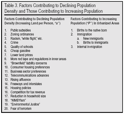
Declining Population Density and Increasing Population
Here we briefly describe a number of the factors put forth by various observers, analysts, and Smart Growth proponents that contribute to the declining population density which, in turn, leads to sprawl. As with the effects of sprawl discussed earlier, there is not unanimous agreement among observers that each of the factors mentioned below is a significant cause of sprawl. Indeed, the April 1999 GAO report quoted above disappointed some activists because it did not find emphatic evidence, no "smoking gun," that certain federal policies encourage sprawl, as Smart-Growth advocates claim.106 Neither the order of the factors listed below, nor the space given to each, is intended to indicate relative importance:
Greater Public Subsidies for Development in Peripheral Regions. It is suggested that massive taxpayer-funded subsidies for infrastructure and facilities like roads, public buildings, water, sewer, and schools in the outer suburbs reduces the cost of development to private developers, businesses, and residents. Thus, more sprawl takes place than otherwise would because the beneficiaries are not paying the true cost of development on the fringe. Some municipalities charge development fees in an effort to recover at least some of the public costs incurred.
Zoning Ordinances that Prohibit Higher Densities and Mixed Uses. New Urbanists contend that overly restrictive zoning ordinances in cities and suburbs contribute to sprawl by prohibiting the higher population densities and mixed residential and commercial uses that occurred in traditional American towns and cities. The earliest application of land-use zoning power by local government occurred in San Francisco in 1867, "to isolate obnoxious land uses in such a way as to protect the environment, both physical and social, of existing residences."107
Widespread adoption of zoning occurred in the second decade of the 20th century as an explicit response to inner city overcrowding exacerbated by "unbelievable numbers of immigrants crowded into cities totally unprepared to cater for their basic needs" and technological innovations such as the steel frame and elevator, which enabled taller buildings and much higher densities in city centers.108 New York City passed the country's first comprehensive zoning ordinance in 1916; by 1929, 754 local governments containing 60 percent of America's urban population had adopted zoning ordinances.
The complete exclusion of industrial, commercial, and high-density residential land uses from exclusive low-density residential zones and their isolation by large distances came about during the era of prosperity and the automobile that followed WWII. "This increased exclusion of uses from zones, coupled with a penchant for low development density (low-density-is-best-density) resulted in vast spread cities of huge zones of developmental uniformity and life-style conformity," observed Lawrence Gerckens in the Planning Commissioners Journal.109
Racism, "White Flight," Culture Shock. "White flight" from the cities and inner suburbs as blacks and other minorities began integrating neighborhoods and schools is often put forward as a root cause of sprawl. How much of this was due to racism or a desire for racial homogeneity on the part of whites versus a fear of declining educational standards, social tensions, and rising crime is impossible to quantify. Historian Kenneth T. Jackson argues that, "reflecting the racist tradition of the United States," the Federal Housing Administration (FHA), established in the 1930s to improve housing standards and provide mortgage insurance, "was extraordinarily concerned with inharmonious racial or nationality groups. It feared that an entire area could lose its investment value if rigid white-black separation was not maintained."110 Thus, "FHA insurance went to [largely white] new residential developments on the edges of metropolitan areas, to the neglect of core cities" that were disproportionately black.
The advent of court-ordered busing to achieve racial balance probably instigated substantial white flight to the suburbs for reasons that included racial ones.
Since the 1980s, another type of racially and ethnically motivated flight to the suburbs has arisen among not just whites but also among blacks and other minorities who flee heavy urban concentrations of recent immigrants from different racial and ethnic backgrounds. An aversion to living in a different, unfamiliar culture appears to be pervasive among large parts of the population and likely provides significant impetus to movement toward newer suburbs.
Crime. This has been and remains a key reason urbanites pack up and head for the suburbs. In a 1999 National Association of Home Builders survey on growth issues, respondents ranked the local crime rate higher than any other factor in buying a new home, even higher than the price, size, and features of the home, with 84 percent rating it as "very important."111 The perception and the reality are that urban cores have much higher crime rates than the suburbs.
Crime (and the next two factors) are major reasons that the flight to the suburbs long ago ceased to be simply "white flight." The phenomenon of "black flight" from cities to suburbs has emerged as a strong trend. From 1980 to 1990, the black population in the suburbs grew 34 percent.112 Blacks have left South-Central Los Angeles in droves for the outlying towns and suburbs on the fringes of the L.A. basin. They have also left Washington, D.C., in large numbers for the surrounding suburbs, in particular those of Prince George's County, Maryland, where they now constitute a majority.
Both Hispanics and Asians are following suit. From 1980 to 1990, the suburban Latino population grew by almost 70 percent, and the suburban Asian population by over 125 percent. "Members of minority groups, like others who choose to flee the cities, move to the suburbs for a variety of reasons: affordable housing, better schools, lower cost of living, and amenities like space and greenery. But most often they say they move to escape the violence and incivility associated with cities," wrote New York Times reporter Karen DeWitt.113
Quality of Schools. Public perception (and often the reality) is that inner cities and inner suburbs have major problems in their public school systems. Conscientious parents unable to afford private schools often make the decision to move to the suburbs so that their kids will obtain a better education, access to better facilities, better and higher-paid teachers, association with peers whose parents tend to be better-educated and motivated, greater personal safety, and the assumption of less exposure to such injurious influences as drugs and gangs. The movement of these highly motivated families helps ensure and accelerate the educational deterioration from which they flee.
Cheap Gasoline. When inflation is taken into account, even with recent hikes, gasoline in the United States is inexpensive both historically and in comparison with other developed countries, which tax it much more heavily. Low prices at the gasoline pump have not only discouraged the use of mass transit, but encouraged outward expansion by keeping the cost of commuting by car (and SUV) very affordable.114 It is often pointed out that U.S. gasoline taxes do not come close to paying the full price of building and maintaining highways and streets. Rarely addressed, however, are the wider social and environmental costs that gasoline combustion imposes in the form of smog, acid rain, global warming, oil spills, and military expenditures to keep oil flowing from distant or dangerous places like Alaska and the Middle East.115 Some analysts have suggested that a "user tax" to recover these public costs ("externalities") would cause prices at the pump to jump, which would discourage waste of this non-renewable resource, and in the process, help discourage sprawl.116
Lower Land Prices in Peripheral Areas. Undeveloped land on the suburban fringe is cheaper than most land in city cores and inner suburbs. Thus, homebuyers naturally gravitate outward instead of inward, because they can get "more house for their dollar."
More Red Tape and Regulations in Inner Areas. Developers have been known to complain that the onerous regulatory apparatus of core cities and inner suburbs is a disincentive to redevelopment there. The National Association of Home Builders refers to "local governments that have erected barriers to higher density development" as an impediment to more efficient development in older suburbs and inner cities.117 Presumably some of these barriers respond to pressure from residents "opposed to higher density development in their own backyards."
Environmental and Liability Concerns Related to "Brownfields." Brownfields are former industrial sites, many of which are tainted with toxic waste. The intent of the "Superfund" law or CERCLA (Comprehensive Environmental Response, Compensation, and Liability Act), enacted in 1980, was to protect the public from past improper hazardous waste disposal (e.g. the infamous case of Love Canal) and impose cleanup costs on liable parties, such as land and business owners.118 An unintended consequence of this law has been to discourage new ownership and development of thousands of contaminated or potentially contaminated sites, many of them within cities, and many which could be rehabilitated at reasonable cost if the liability questions could be resolved. Removal of these sites from the real estate market removes one source of urban land and increases pressure on outlying areas.
Consumer Housing Preferences. Whether due to an innate human or a uniquely American desire for "elbow room" and greater freedom, or to the success of a relentless propaganda campaign over the last 50 years, there is a undeniable desire on the part of consumers for suburban or semi-rural lifestyles with larger homes and large yards, a safer environment, more contact with nature, and less traffic congestion.119 A 1948 General Motors advertisement in Life magazine carried the headline "Give a Man some room to Roam in!" beside a drawing of a boy and his dog playing in the "wide open spaces." The text of the ad boomed: "as cars grew better and more useful, cities and towns changed. They exploded into the countryside, spreading real estate developments, suburbs and smart new neighborhoods all over the local map."120
In an April 1999 "Consumer Survey on Growth Issues" of 5,000 households nationwide, the Smart Growth Task Force of the National Association of Home Builders found that "Americans overwhelmingly prefer a single-family detached home on a large lot in the suburbs to any other type of home." According to this survey, which was carried out by a trade organization with a strong vested interest in building high-value houses, 83 percent of the respondents prefer to live in a single family detached home, 6 percent in a townhouse, and just 2 percent in an apartment in a multifamily building.121
Preferences of the Private Business Sector. Some analysts believe that business and industry, including commercial tenants, have expressed a preference for easy highway access and plenty of free parking for their employees and customers. Commercial lending practices for building construction loans are also claimed to favor suburban locations.122
More and more businesses are moving their bases of operation from core cities to suburban office parks and "campuses." For example, in 2001, the offices of the nationally-distributed newspaper USA Today and its parent company Gannett moved from Rosslyn, Virginia, just across the Potomac River from downtown Washington, out to the Tyson's Corner area just beyond the Capital Beltway. In part, businesses are making themselves more convenient to where their executives and many of their employees live. But their moves also confound expensive hub-and-spoke mass transit systems and provide yet another disincentive for their employees to live in the core cities and inner suburbs.
Telecommunications Advances. The personal computer and the Internet, e-mail, and World Wide Web, in addition to telephones, cellular telephones, and the capability of teleconferencing have all enabled employees and the self-employed alike to sever the link that formerly bound them to their work places on a daily basis. With the ability to work at home and not have to face the daily commuting grind, some workers are being released from having to live within a certain distance of their workplaces. The home itself becomes a secondary or primary workplace. This phenomenon not only makes it easier to live in the outer suburbs, but also contributes to the exurban explosion in some areas. Workers can live beyond the confines of urbanized areas altogether, in scenic, rural settings like California's Sierra Nevada foothills, the Colorado Front Range, or Virginia's Blue Ridge Mountains and Shenandoah Valley.
Rising Affluence. There have been suggestions that greater affluence itself fosters sprawl. Simply put, consumers of greater means consume more, and one way of consuming more is to purchase a larger home on a larger lot with two or more expensive cars in the driveway, and perhaps even a pool in the backyard, all in a more spacious, park-like, low-density neighborhood. The desire for greenery and open space now seems deeply imbedded in our culture: witness the number of upper middle class families with second homes or cottages in the country, and the number of celebrities with ranches or homes in the likes of Jackson Hole, Aspen, and Taos. Should the affluent continue to become even more affluent in the 21st century, there is likely to be an ever-intensifying land rush in the more scenic parts of the country, as seen in the Rocky Mountain West.
Freeways and the Interstate Highway System. "While the Interstate Highway System has had a multitude of impacts, many positive, it has also led to dispersal of growth and development," notes the Planning Commissioners Journal.123 The President who launched the extensive development of interstates, Dwight D. Eisenhower, wrote of how it transformed the face of America:
"On June 26, 1956 I signed [the Federal Aid Highway Act] into law. It was not only the most gigantic federal undertaking in road-building in the century and a half since the federal government got into this field it was the biggest peacetime construction project of any description ever undertaken by the United States or any other country...
"The amount of concrete poured to form these roadways would build eighty Hoover Dams or six sidewalks to the moon. To build them, bulldozers and shovels would move enough dirt and rock to bury all of Connecticut two feet deep. More than any single action by the government since the end of the war, this one would change the face of America. Its impact on the American economy the jobs it would produce in manufacturing and construction, the rural areas it would open up was beyond
calculation.124
Eisenhower's "pivotal" role in launching the interstate highway system was acknowledged in 1990 when President George H. W. Bush signed legislation that changed its name to the "Dwight D. Eisenhower System of Interstate and Defense Highways."125
"The construction of free beltways and expressways has subsidized suburban development," insists transportation writer Howard P. Wood in a publication of the free-market, libertarian-oriented Cato Institute.126 One of the unexpected side-effects of the new subsidized highway networks has been the sprouting of so-called "edge cities," auto-dependent centers in the suburban fringe with substantial office space, leasable retail space, and more jobs than bedrooms. A classic example is Tyson's Corner, adjacent to the "Beltway" (Interstate 495) in Washington, D.C.'s, northern Virginia suburbs, with its bustling office buildings, shopping (including two large malls), restaurants, hotels, and entertainment.127
The American love affair with roads and cars symbolizes the mobility and freedom we cherish. Even if our means of expressing these values have advanced remarkably in the last century, the values themselves are not new. Walt Whitman wrote of them in the 1800s in his poem "Song of the Open Road." Writers as diverse as Robert Frost and Jack Kerouac have used roads as metaphors for life in their poetry and prose. Some have gone as far as to suggest that roads "symbolize the essence of our culture."128 The bitter irony of course, is that with sprawl comes traffic congestion and roads that come to resemble parking lots more than freeways. The more drivers there are chasing the freedom of the open road, the more it vanishes like a mirage.
Housing Policies. Federal housing policy since the 1930s has helped facilitate the movement of the middle-class out of the city centers into an ever-widening suburban periphery.129 The Federal Housing Administration (FHA) was created in 1934 to encourage improvements in housing standards and conditions and provide for a system of mutual mortgage insurance. "The creation of the FHA also guaranteed that the dominant American dwelling unit of the future would be the single family home on a suburban lot" argues planning historian Laurence Gerckens.130
In addition, some observers have cited the federal income tax deduction for home mortgage interest payments as contributing to sprawl, because this subsidy provides a financial incentive to lower-density private home ownership vis-a-vis higher-density apartment dwelling.
Competition for Tax Revenue. Among others, former EPA Administrator Christie Todd Whitman, while New Jersey Governor, identified the scramble for development between competing municipalities as a source of sprawl: " too many towns bend over backwards to pursue development, hoping it will help balance their budgets. In the process, they strain not only their backs but also the services needed to support this development. The result is a double whammy: less open space and higher property taxes." 131
Reduction in Household Size. Over the last 30 or 40 years, the American household has undergone a dramatic change. Overall, there are fewer and later marriages, fewer children, a higher divorce rate, and many more single adults living alone. In 1970 the average household was 3.14 people; by 1990 it was 2.65. This is a 0.49 person change or a 15.6 percent reduction.132
All of this has increased the ratio of households to population. The net result is a greater number of homes per 100 people than there once was that is, a lower population density. These homes take up additional space, increasing pressure for sprawl.
"NIMBYism." Not In My Backyard! is what many suburbanites and urbanites holler when confronted with proposals for new projects in their own neighborhoods, whether for affordable housing, higher-density development, stadiums/sports arenas, shopping malls, new freeways, or hazardous waste incinerators.133 The term NIMBY has a generally pejorative connotation because it was coined by those frustrated with NIMBYism. The position is frequently criticized as selfish and hypocritical by local politicians, public officials, and private project proponents exasperated by fierce local opposition to a given project that they believe has broad collective benefits. On the other hand, as one California community activist noted: "The dismissive NIMBY term pops up with such dismaying frequency in local public policy debates that a translation of the acronym is not necessary. It is as if business imperialists who never seem to inhabit the communities they wish to strip mine can wave away citizen soldiers defending their neighborhoods with a single rhetorical flourish." 134
The upshot of NIMBYism in terms of the sprawl issue is that it is often easier and less controversial to site major new projects, be they subdivisions or airports, in less populated sites at or beyond the fringe of the urban area. There are simply fewer neighbors to get upset, and many of the affected property owners may actually be speculators looking to reap windfall profits by selling their real estate investments to developers. Since "time is money" in the business world, the threat or reality of delays, lawsuits and injunctions bogging down a project must be taken seriously. When the Walt Disney Corporation pulled out of its proposed "Disney's America" theme park in Northern Virginia in 1994, this was more the exception than the rule. It took the proximity of hallowed ground the first battle of the Civil War at Manassas/Bull Run to galvanize opposition to the proposal by some local interests and nationally renowned historic preservationists.
"Environmental Justice." On February 11, 1994, President Clinton signed Executive Order 12898 Federal Actions to Address Environmental Justice in Minority Populations and Low Income Populations officially ordering federal agencies to "make achieving environmental justice part of their mission." 135 The U.S. Environmental Protection Agency's Office of Solid Waste and Emergency Response has been designated the lead agency to ensure implementation of this Executive Order. EPA defines Environmental Justice (EJ) as the "fair treatment for people of all races, cultures, and incomes, regarding the development of environmental laws, regulations, and policies." 136
The premise of Environmental Justice and its mirror opposite, "environmental racism," is that minority and poor communities have been subjected systematically and disproportionately to pollution, toxic health threats, and other environmental insults. Activist scholars like sociologist Robert Bullard provided the theory and empirical studies that helped concerned minority citizens scattered around the country "coalesce into a movement challenging what they saw as an unmistakable and insidious tendency to make communities of color society's dumping ground."137
There has been some disagreement among Environmental Justice advocates and other observers as to whether minority and poor communities have been specifically targeted out of disregard or actual racism on the part of private interests and indifferent public officials, or whether this outcome has been more indirect, as a result of the comparative powerlessness of the poor and minorities in American society. As a representative of one waste management company writes: "Most hazardous waste sites are located on property that was used as a disposal site long before modern technologies were available. The communities around these sites are typically economically depressed as a result of past activities. Poor people may be forced to live there because of economic constraints. It is unfair to blame the siting of these particular facilities to the current demography of the area."138
As with NIMBY's discussed above, the major implication for sprawl of the emergence of environmental justice over the last 15 years is that it has become more difficult to locate with impunity job-creating but environmentally dubious projects in majority-minority, inner-city neighborhoods. As Brookings Institution scholar Christopher H. Foreman, Jr., observes: "Environmental justice advocates assert, plausibly enough, that poor and minority areas are a magnet for environmental hazards in part because wealthier and whiter ones that are better able to defend their interests can shun them. But whatever may have been true in the past, these days minorities and whites alike often effectively marshal local outrage to play the Not In My Backyard (NIMBY) game."139 What this likely means is more development pressure on the urban periphery and rural areas, i.e. lower density and sprawl.
Fear of Terrorism. In the wake of the terrorist attacks of September 11, 2001, the very future of high-rise living and skyscrapers has been called into question. If indeed both residents and workers in tall buildings around the country feel insecure after the toppling of the twin towers at the World Trade Center, it is possible that demand for the construction of future skyscrapers will decline. Of course, stacking businesses and homes atop one another has allowed urban densities to increase, thereby reducing pressure to expand outward. Just how architects, builders, and developers will respond is still uncertain at this point. Nevertheless, it might be not just tall structures that people feel vulnerable in, but dense cities as well due to the greater publicity threats from biological, chemical, and even radioactive onslaughts have received. This may lead to a greater exodus toward less-densely populated suburbs and rural areas in the coming decades. As one essayist from the rural West wrote in a national newsmagazine after the horror of 9-11, the timeless howling of the coyotes never sounded so good.
The above list is not intended to be exhaustive. And there are different ways and terms for expressing some of the same diverse concepts. What each of the factors above has in common is the net effect of reducing population density; that is, increasing land area per person. Now let us look at the other half of the sprawl equation: Population growth.
Factors Contributing to Population Growth in the United States
At the national level, there are three main factors contributing to population growth: Births to the native born, immigration, and births to immigrants (i.e. foreign born). At the metropolitan level, a fourth factor becomes relevant: internal migration (e.g., from San Francisco to Portland, or from Los Angeles to Las Vegas).
The United States population stood at 203 million in 1970. By early 1990 it had grown to 248 million.140 As of January, 2000, the "population clock" at the U.S. Census Bureau website estimated that over 274 million people call America home.141 By April, 2000, however, something shocking had happened. The U.S. grew to 281 million adding seven million new residents just three months! Actually, what occurred is that the 2000 Census was conducted, making a decade of estimates based on the 1990 Census obsolete. (In other words, in January 2000, the nation's actual population was about seven million greater than what the obsolete estimate on the Census "population clock" indicated.) This huge discrepancy, virtually all of it accounted for by immigration levels (especially illegal immigration) much greater than even professional demographers had believed was occurring, was proof positive of the dramatic demographic consequences current immigration levels are having on the United States.
The upshot is that in the 1990s the U.S. population grew by almost 33 million, or about 3.3 million (1.2 percent) per year. Only Canada and Australia among developed nations have higher population growth rates. The populations of these countries are much lower, however (Canada about one-tenth the U.S. population, Australia about one-twentieth.) The United States actually adds far more people than these two countries combined. In fact, an examination of the Population Reference Bureau's World Population Data Sheets showed that the United States annually adds more people than all developed countries in the world combined. Moreover, the U.S. population is expected to grow by three times as much as the combined population growth of 44 other developed countries in the world by 2025; that is to say, three-quarters of all growth in the entire "developed world" will take place in just one nation our own.142
On January 13, 2000, the Census Bureau released its first projections of the century, including the first ever to the year 2100. If fertility, mortality, and immigration remain relatively unchanged, the U.S. population is projected to continue its rapid expansion, surpassing 400 million before 2050 and reaching 571 million by 2100.143 The nearly 300 million people that would be added during this century break down to an average of almost three million per year below the 3.3 million per year added in the 1990s. The 571 million projection for 2100 must be regarded as low since it is based on legal and illegal migration levels significantly below the average of the last decade. For example, the Census Bureau has recently updated its mid-range projection for 2050 from 404 million to 420 million but not yet updated projections for the last half of the century.144 Let's look at the components of current U.S. population growth:
Births to the Native Born. According to the National Center for Health Statistics (NCHS), there were 3,944,046 total births in the United States in 1998.145 Approximately 80 percent of these births, or 3,155,000, were to native-born Americans. Overall, native born American women have a total fertility rate (TFR) of about 1.9, which is below the "replacement level" of 2.1.146 The TFR is a standardized measure of the number of live births an average woman would have if her actual fertility matched the age-specific fertility rates for a given year of all women in the group to which she belongs (i.e., an estimate of how many children an average woman will have during her life).
A TFR of 1.9 means that native-born Americans are not having enough children to "replace themselves," and that over several generations, their population growth will taper off and then actually begin a slow decline. This began to happen when the TFR of the U.S. native-born population slipped below 2.1 for the first time in the early 1970s. At present, only "population momentum" is pushing growth in the numbers of native-born Americans, but with less and less force.
People die too, and these deaths must be subtracted from births to derive a "rate of natural increase" of the native-born population. Using NCHS statistics for the year 1994, there were 3,264,505 births to native-born Americans and 2,074,136 deaths, for a net natural increase of 1,190,369.147 In addition, a small number of Americans emigrate from the United States every year to settle permanently in other countries. Overall, from 1991 to 1996, the net addition of native born to the U.S. population was approximately 7,040,000, or 42 percent of the total estimated population growth of 16,750,000.148 It must be remembered that actual growth in this five-year period was greater than estimated growth (as the 2000 Census revealed) because of higher than expected immigration. Therefore, the percentage of total population growth due to the native born was actually well under 40 percent.
Immigration. In the 1990s, total immigration (legal and illegal combined) averaged far above one million people per year. The 2000 Census showed that during the 1990s, over 13 million new legal and illegal immigrants arrived in the United States. By the end of the 1990s, a net of 1.5 million new immigrants were being added to the country each year. These figures include one million legal immigrants and a net increase in the illegal alien population of 500,000.149
Immigration levels have risen rapidly in the 38 years since the landmark Immigration and Nationality Act Amendments of 1965, which replaced national origins quotas with an emphasis on "family reunification." This initiated a spiraling process of "chain migration" which continues unabated to this day. The number of legal and illegal immigrants entering the United States has more than quadrupled over the last four decades and the number of immigrants living in the United States has more than tripled, from 9.6 million in the 1970 Census to 31.1 million in the 2000 Census. By historical standards, the number of immigrants living in the United States is without precedent. Even at the peak of the great wave of immigration in the early 20th century, the number of immigrants living in the United States (13.6 million in 1910) was only about half what it is today.150
With the failure of immigration reform advocates to successfully push reductions in legal immigration through Congress in 1996 reforms that closely matched recommendations of the U.S. Immigration Reform Commission chaired by the late Rep. Barbara Jordan and with continued high volumes of illegal migration, there is no sign on the horizon that the immigration wave will abate anytime soon.
Births to Immigrants. The amount of direct immigration to the country is large and grew substantially from the 1960s to the 70s, the 70s to the 80s, and the 80s to the 90s. The full measure of immigration's contribution to U.S. national population growth cannot be gauged, however, without including the "downstream" or indirect effect of births to immigrants. After all, these are births that would not have occurred in the United States, and would not have boosted U.S. population, had that immigration not occurred. Yet by and large, official sources of population projections like the Census Bureau tend to combine births to immigrants and to natives together as "natural increase." This has led to considerable confusion among many who have misunderstood these data and thus have understated the influence of immigration on population growth.
On closer examination however, analysts will find that the Census Bureau has recognized that: "the impact of immigration is far greater if it is seen to include the offspring of immigrants over an extended period of time.Most of the importance of net migration in understanding population growth is the natural increase of the population it adds." 151 Moreover, as population researcher Ed Lytwak stresses: "The growth in total numbers of foreign-born women was compounded by much higher fertility in large segments of the foreign-born population." 152
Foreign-born women have fertility rates almost 40 percent higher than native-born women, according to a 1997 Census Bureau report.153 While the foreign born accounted for less than 10 percent of the nation's population in 1996, they accounted for over 19 percent of the nation's births, and 34 percent of the nation's "natural increase" (births minus deaths).154
When immigrants and their offspring are both considered, a fuller appreciation of how immigration has grown to occupy the central role in forging the nation's demographic present and future emerges. In 1950, immigration accounted for only 1 percent of total U.S. population growth. This grew to 5 percent in 1960, 13 percent in 1970, 38 percent in 1980, 58 percent in 1990. Table 4 shows the native-born vs. foreign-born shares of population growth in the first half the 1990s. It must be pointed out that the numbers in Table 4 for 1996 are based on Census Bureau population estimates made prior to the 2000 Census. The 2000 Census revealed that the actual level of immigration was much higher than the level used by the Bureau to generate its mid-decade population numbers.
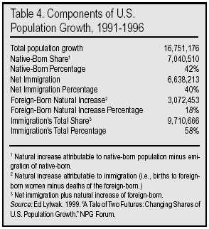
If we examine immigration's impact on population growth since the 2000 Census, using more accurate estimates for the level of immigration, we find the impact of immigration is even larger than found in Table 4. Analysis done by the Center for Immigration Studies shows that new immigrants and births to the foreign born accounted for 86.7 percent of the population growth between 2000 and 2002.155
Census projections show that at the end of this century, the U.S. population is likely to grow to more than 570 million, based on current trends. Of that growth, 100 percent is likely to be due to post-1970 immigration.156 As a result of the dramatic growth in immigration rates, the nation's demographic future has been transformed. As recently as the late 1980s, the Census Bureau was projecting that America's population would crest at 302 million in 2040. Now it is forecasting growth with no end in sight.
Internal Migration. The population growth that many urban areas are now experiencing is also partly generated by migration from other American cities. This source of growth has been particularly pronounced in certain towns and cities in states such as Washington, Oregon, Nevada, Arizona, Colorado, New Mexico, Florida, Georgia, and North Carolina. The causes of this internal migration are various: Structural changes in the nation's economy as a result of continuing maturation and globalization, the emergence of "footloose" industries and fields, the pursuit of places with higher amenities and quality of life, the abandonment of the "snow belt" for the "sun belt," and so forth.
Another important cause is internal migration induced by international migration. Geographer William Frey has shown that a good deal of internal migration, especially among the working class or less well educated, may actually be prompted by immigration from foreign countries into gateway cities like New York, Los Angeles, and Miami.157 That is, the native born depart certain areas because of economic factors like intensifying job competition and wage depression or social/cultural factors like language barriers, ethnic/racial tensions, crime, drugs and gangs, or just an increasingly uncomfortable feeling of being an outsider in one's own home town.
Thus, federal immigration policies are actually a significant, indirect cause of population growth in many cities and towns with relatively small flows of new, foreign-born immigrants.
In any case, at a national level, internal migration represents a zero sum game one city's loss of population is another's gain. Thus, in the aggregate, internal migration does not drive population growth in the same way that the previously mentioned factors do. It simply redistributes the population the country already has. Nevertheless, in some rapidly growing cities, it does represent a significant factor.
The Findings section will quantify the respective contributions of the density and population factors in the sprawl equation. Specifically, it will show how closely sprawl is linked to growth in per capita land consumption and population growth.

The Smart Growth Solution
The causes and effects of sprawl cited in the previous two sections have propelled to prominence what seems to be a promising solution "Smart Growth." A broad-based movement has coalesced in the last decade that is anti-sprawl yet pro-growth. As former Maryland Governor Parris Glendening, one of the highest-ranking political leaders in the movement, puts it, "It has never been our intention to stop growth. We never wanted No Growth, or even Slow Growth. What we opposed was allowing the State to subsidize the unplanned, or poorly planned growth that was eating up our countryside at an alarming rate."158 The Urban Land Institute adds that, "Smart Growth initiatives are removing obstacles to development that enhances existing communities, is compatible with the natural environment, and uses tax dollars efficiently while attracting private investment."159
Smart Growth is supported by a diverse coalition of land use and transportation planners, local, state and federal government agencies and elected officials, environmentalists, charitable foundations, historic preservationists, "new urbanists," affordable housing advocates, local growth control activists, and even churches and the home building industry.
Principles of Smart Growth. What is Smart Growth? According to the Smart Growth Network, it "invests time, attention, and resources in restoring community and vitality to center cities and older suburbs. New Smart Growth is more town-centered, is transit and pedestrian oriented, and has a greater mix of housing, commercial, and retail uses. It also preserves open space and many other environmental amenities."160 The Network emphasizes however, that there is no "one-size-fits-all" Smart Growth solution. Each community faces its own particular challenges and opportunities.
In its report How Smart Growth Can Stop Sprawl, the Sprawl Watch Clearinghouse promotes a number of strategies to revitalize cities and arrest sprawl, including:
- Regional consolidation and annexation
- State and federal government promotion of regionalism
- Regional tax base sharing and other tax reforms
- Metro-wide planning and development
- Elimination of infrastructure subsidies
- Urban Growth Boundaries
- Downtown revitalization and historic preservation
- Reclamation of urban "brownfields"
- Location-efficient mortgages
- Reducing dependency on the automobile
- Innovations in zoning and community design
- Affordable housing strategies 161
Smart Growth's underlying premise and overarching promise have perhaps best been articulated by Parris Glendening again: "inner city disinvestment and suburban sprawl are two sides of the same coin by curbing sprawl, Maryland can save farmland and forests while simultaneously revitalizing our older suburbs and urban centers."162 Maryland's Smart Growth initiatives encourage municipalities to avoid higher costs for new infrastructure in outer areas by investing in existing communities and thus qualifying for state tax credits, grants, low-interest loans, and other incentives.
In general, Smart Growth adopts a holistic approach to curbing sprawl that emphasizes interconnectedness. It explicitly recognizes that one cannot save open countryside only by designating greenbelts and urban growth boundaries and purchasing open space. An array of other tools that make already developed urban cores and inner suburbs attractive and affordable must be creatively utilized to keep existing and new residents from spreading outward. Smart Growth is also about preventing the exodus of people from rural towns and counties to urban areas by finding new, sustainable sources of economic vitality for those areas.163
In 1991, a group of innovative architects and planners in California met and developed the Ahwahnee Principles, the preamble of which states:
Existing patterns of urban and suburban development seriously impair our quality of life. The symptoms are: more congestion and air pollution resulting from our increased dependence on automobiles, the loss of precious open space, the need for costly improvements to roads and public services, the inequitable distribution of economic resources, and the loss of a sense of community. By drawing upon the best from the past and the present, we can plan communities that will more successfully serve the needs of those who live and work within them. Such planning should adhere to certain fundamental principles.
The Ahwahnee Principles include the following:
- All planning should be in the form of complete and integrated communities containing housing, shops, work places, schools, parks, and civic facilities essential to the daily life of the residents.
- Community size should be designed so that housing, jobs, daily needs, and other activities are within easy walking distance of each other.
- A community should contain a diversity of housing types to enable citizens from a wide range of economic levels and age groups to live within its boundaries.
- The community should have a center focus that combines commercial, civic, cultural, and recreational uses.
- The community should contain an ample supply of specialized open space in the form of squares, greens, and parks whose frequent use is encouraged through placement and design.
- Public spaces should be designed to encourage the attention and presence of people at all hours of the day and night.
- Each community or cluster of communities should have a well-defined edge, such as agricultural greenbelts or wildlife corridors, permanently protected from development.
- Streets, pedestrian paths, and bike paths should contribute to a system of fully-connected, interesting routes to all destinations. Their design should encourage pedestrian and bicycle use by being small and spatially defined by buildings, trees and lighting; and by discouraging high speed traffic.
- Wherever possible, the natural terrain, drainage, and vegetation of the community should be preserved with superior examples contained within parks or greenbelts.
- The community design should help conserve resources and minimize waste.
- Communities should provide for the efficient use of water through the use of natural drainage, drought tolerant landscaping and recycling.
- The street orientation, the placement of buildings and the use of shading should contribute to the energy efficiency of the community.164
These principles not only strive to enhance livability and quality of life, but also to improve environmental sustainability through an emphasis on resource-conserving design. Many Smart Growth proposals incorporate the ideas behind the Ahwahnee Principles.
Smart Growth's View of Population Growth and Density. What does Smart Growth have to say about population growth? In a word, nothing. The more environmentally oriented among Smart Growth advocates appear to neither support nor oppose population growth in urbanized areas. By and large, planners, civic officials, private businesses, and developers who support Smart Growth appear to welcome population growth in their area as a reflection of economic vitality. Smart Growth is thus a means of allowing population and economic growth to continue while minimizing sprawl, congestion, and other "negative feedbacks" that threaten not only quality of life but also future growth.
Thus, explicitly or implicitly, Smart Growth means higher population density. Curbing population and sprawl at the same time can only be accomplished through ever-higher residential densities. As Richard Lacayo writes in Time magazine: "smart growth envisions a nation packaged into town houses and apartments, a country that rides trains and buses and leaves the car at home."165
In their pronouncements, most environmentally inclined Smart Growth advocates tend to gloss over the part about rising density. For instance, former Vice President Al Gore told Time magazine in 1999: "Let's build more new homes, but build them in places that help make people's lives more enjoyable."166 Nothing in that statement implies having to live closer together or on top of each other, with smaller lots and yards, or in townhouses and apartments. Other Smart Growth proponents are quite candid about the need or even the desirability of higher densities. A book published by the Urban Land Institute is entitled Density By Design: New Directions in Residential Development.167 The publisher describes its contents in this manner: "case studies showcase developments of small lot subdivisions, accessory units, housing in new urbanist communities, higher-density and transit-oriented development, mixed-income and mixed housing types, infill, and adaptive use."
The 200,000-member National Association of Home Builders (NAHB) is on record as stating that "Smart Growth means meeting the underlying demand for housing created by an ever-increasing population and prosperous economy by building a political consensus and employing market-sensitive and innovative land-use planning concepts. At the same time, Smart Growth means meeting that housing demand in smarter ways by planning for and building to higher densities, preserving meaningful open space and protecting environmentally-sensitive areas."168 The NAHB states:
The nation's population is projected to grow by about 30 million people over the next 10 years. More than a million new households are being formed annually. America's home builders will have to construct between 1.3 and 1.5 million new housing units each year just to meet the underlying demand for shelter during the next decade. This does not include the additional housing units and support required to meet the housing needs of more than 5 million Americans who still live in substandard housing or pay more than 50 percent of their incomes for rent.169
Under the heading of "Using Land More Efficiently," the NAHB states its support for higher density:
NAHB supports higher density development and innovative land-use policies to encourage mixed-use and pedestrian-friendly developments with access to open space and mass transit. To generate greater public support for this type of development, however, will require a change in thinking by people opposed to higher density development in their own backyards, by local governments that have erected barriers to higher density development and are easily influenced by citizen groups opposed to any new growth and by typical housing consumers who continue to favor a single-family home on an individual lot.170
Smart Growth has no shortage of critics, most of them coming from organizations with property rights and free market perspectives, like the Cato Institute, Goldwater Institute, and the Competitive Enterprise Institute. By and large, the critics question the extent of the problem in the first place, whether Smart Growth will solve that problem, and at what cost to freedom, property rights, equity, and prosperity.171
In contrast, the authors of this study share the premise of Smart Growth proponents that sprawl is a serious and growing problem. But we do question whether Smart Growth can succeed in the face of never-ending, rapid population growth. The fundamental challenge for Smart Growth proponents is two-fold: 1) How to convince American consumers, neighborhoods, and local governments to make changes and sacrifices necessary to keep "downtowns livable and affordable so people stay happily bunched there;"172 and 2) If population continues to grow instead of stabilizing, how to "bunch" these residents at higher and higher densities without them spilling over into the countryside. In other words, the challenge is to find ways to keep adding straws to the camel's back without breaking it.
Findings
This study focuses on the loss of undeveloped land (cropland, range, pasture, forest, and other natural habitat and open space) in the United States. As pointed out earlier, at its most basic level, there can only be three reasons for an increase in developed land: either each individual is consuming more land, there are more people, or both factors are working together to create sprawl. This study attempts to quantify the relative roles of (1) rising per capita land consumption and (2) population growth.
Data Sources
The primary quantification in this study is done by comparing those two factors with the overall increase in statewide Developed Land between 1982 and 1997 in all states but Alaska.173 The state data come from the U.S. Department of Agriculture's Natural Resources Conservation Service. A secondary quantification also compares the two major sprawl factors but limited to the 100 largest Urbanized Areas (between 1970 and 1990). These data come from the U.S. Census Bureau. Both the state and city data are useful for understanding sprawl, and for that reason both are used in this analysis. Examining two very different sets of data gives us more confidence in our results than if only one were available.
U.S. Department of Agriculture's Data. Developed land is defined by the U.S. Department of Agriculture's Natural Resources Conservation Service (NRCS) in its 1997 National Resources Inventory (NRI), originally released in December 1999 and then re-released in January 2001 with revised and corrected figures.174 The NRI is primarily oriented toward private and non-federal lands, with an emphasis on the quality and quantity of the nation's productive resource land base, that is to say, croplands, range, pasture, and forestlands. But it also quantifies the loss of other non-federally owned open spaces and natural habitat, as well. The NRCS identifies Developed Lands as those non-federal lands that have been removed permanently from the rural land base. The Developed Land category includes:
- large tracts of urban and built-up land of 10 acres or more;
- small tracts of built-up land between 0.25 acre and 10 acres in size; and
- transportation land (roads, railroads, associated rights of way) outside of these built-up areas.175
U.S. Census Bureau's Urbanized Areas. Our second measure of sprawl is obtained by drawing on decennial statistics for population, for urbanized land per average resident, and for total urbanized land from U.S. Bureau of Census data on Urbanized Areas of the United States.176 Most recent studies and reports that have attempted to quantify land consumption due to sprawl have used the same data. (The Census definitions and methodology for measuring each Urbanized Area are described in Appendix F.)
An "Urbanized Area" (UA), as defined by the Census Bureau, is a continuously built-up or developed area with a population of at least 50,000.177 It consists of one or more "central places" as well as densely-settled surrounding areas which the Bureau terms "urban fringe." The central place(s) and urban fringe may be thought of as the urban core and suburbs of a given UA. The Census Bureau introduced the UA concept in the 1950 census as part of its efforts to differentiate the urban and rural portions of the nation's population (See Appendix F).
Per Capita Consumption Factors Alone Cannot Explain Overall Sprawl
As discussed earlier, most anti-sprawl publications and programs focus their attention on those factors that increase the average consumption of land by residents, with the goal of reducing that per capita land consumption. We call this increase "per capita land consumption growth" or "Per Capita Sprawl."
Defining Per Capita Sprawl. To illustrate, we will use Georgia, where the public has grown increasingly alarmed at the pace of sprawl. Per capita land consumption in Georgia was 0.419 acres in 1982. It grew to 0.529 acres in 1997. Thus, the Per Capita Sprawl over that period was 0.110 acres, or 26.2 percent. From this information, it is obvious that Georgians must address Per Capita Sprawl if they are to slow overall sprawl in the state.
The concept of Per Capita Sprawl, or per capita land consumption growth, is immensely useful because it compresses into a single figure the results of dozens of factors listed earlier as probable causes of consumption increases. Per capita urban or developed land consumption is not limited to the size of a person's house lot or to a person's proportion of the land covered by an apartment complex. It also includes a portion of all the other land that has been converted from rural to urban use to provide for jobs, industry, commercial establishments, recreation and entertainment, shopping, parking, transportation, storage, government services, religious and cultural opportunities, waste handling/disposal, and education. In more rural settings, it would include rural housing and vacation homes and also built-up or heavily modified landscapes associated with agriculture and resource extraction like food processing facilities, mines, mills and smelters, quarries, port facilities, sawmills and lumberyards, hydroelectric dams, and so forth. Thus, the level of per capita land consumption is based both on direct individual decisions and behavior, and on collective decisions made through the government and the marketplace. The effect of all urban planning, zoning, development, and transportation decisions shows up in the per capita land consumption figure. The amount of developed land in predominantly rural settings is a function of similar decisions, as well as those made by federal and state land management agencies, agribusiness and resource industries.
In the end, per capita land consumption under Natural Resources Conservation Service data is calculated by dividing the total developed land area of a given state by the total number of residents in that state. Under the Census Bureau data, the total amount of land in an Urbanized Area is divided by the population of that area. (See Appendix D for more on calculating per capita land consumption.)
Per Capita Sprawl and Smart Growth. It is very difficult to measure precise effects of trying to change any one of the planning, consumption, and other behavioral factors as causes of land consumption growth. But we can determine the overall effect of all those factors together by looking at the simple statistic of the average amount of developed or urban land per resident in an entire state or any Urbanized Area. If that per capita land consumption figure goes up markedly, then we know that Smart Growth efforts related to the above factors either have not been undertaken or are failing to achieve their desired result of higher densities.
If the per capita figure grows only slightly, or remains the same, and especially if it decreases, then planning, consumption, and behavioral factors are collectively moving in the direction desired by the anti-sprawl leaders. It is difficult to determine whether or not their efforts have any impact, but we do know in such cases that per capita land consumption patterns are being brought under control.
Per Capita Sprawl Rate Far Less Than Overall Sprawl Rate
Smart Growth Can Affect Per Capita Sprawl. The nationwide "Smart Growth" movement that has emerged to fight sprawl takes aim at some of those many causes of Per Capita Sprawl, which is measured in the second and fifth columns of Table 5. The Smart Growth movement is composed of many disparate interests and many variations can be found among their proposals, but all advocate tools that can slow the increase in per capita land consumption.
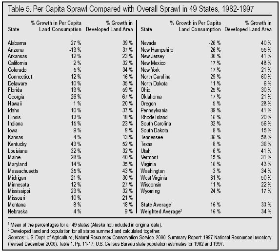
Our literature search found that most media stories, advocacy programs, governmental reports, and political statements about sprawl have focused almost entirely on development esthetics, reducing public costs, and the land-use and consumption factors that cause per capita land growth. This would suggest that Per Capita Sprawl explains most, if not all, of the Overall Sprawl in the nation's Urbanized Areas and the increase in overall developed lands throughout the countryside. Our hypothesis questioned the validity of such a supposition that appears to deny that population growth explains a significant amount of sprawl.
Per Capita Sprawl Is Only One Part of the Story. One way to determine if growth in per capita land consumption indeed explains most of sprawl is to compare the percentage growth of per capita land consumption with the percentage growth of all developed land, which is what Table 5 does for the 49 states surveyed in the 1997 National Resources Inventory. Using Georgia as an example, we see a 26 percent increase in per capita land consumption. But the overall development of rural land increased by 67 percent. If the factors causing growth in per capita land consumption were the overwhelming cause of Georgian sprawl, their percentage growth would be nearly as high as the 67 percent Overall Sprawl, or certainly well over half of 67 percent. Instead, Per Capita Sprawl was less than half.
Thus, the simple exercise of comparing the two percentage growth rates shows the invalidity of the supposition that growth in per capita land consumption is the overwhelming cause of rural land development in Georgia.
When we look at the side-by-side percentage comparisons for all states, we find:
- Most states were like Georgia, with the percentage growth in developed land being considerably larger than the percentage growth in per capita consumption. It was twice as high in Wisconsin, three times as high in Kansas, four times as high in Texas, seven times as high in Colorado and 16 times as high in California.
- In only six states were the percentages in the two columns close enough to suggest that nearly all the sprawl was related to growth in per capita land consumption (Iowa, Louisiana, North Dakota, Pennsylvania, West Virginia, and Wyoming).
- In 24 states, per capita land consumption did not grow at even half the rate of Overall Sprawl.
Obviously something more than just per capita sprawl is at work in producing the loss of undeveloped land in most states. (That is especially true in Arizona and Nevada where per capita land consumption did not grow at all. That phenomenon is discussed later in the report.) By comparison, we find much the same situation in the 100 largest Urbanized Areas: there, as well, very few of the Per Capita Sprawl percentages are even close to as high as the Overall Sprawl percentage.
Focusing Only on Per Capita Sprawl is Too Narrow. Figure 2 shows that for the 100 largest metropolitan areas combined, Per Capita Sprawl growth was a significant 22.6 percent. But overall sprawl growth was more than twice as high at 51.5 percent. We can see in both the state and city figures that all the factors leading to growth in per capita land consumption simply have not produced enough sprawl to explain the overall increase in land development. Clearly per capita land consumption growth is a major factor but not the overwhelming factor in America's urban sprawl and the overall spread of development in states rural areas. Though the statistics for a few states as well as some of the Urbanized Areas seem to justify a single-factor anti-sprawl approach, most of the states and cities fit another explanation, one in which both Per Capita Sprawl and the other major factor population growth must be tackled if Overall Sprawl is to be seriously slowed.
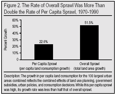
This finding would indicate that most Smart Growth efforts are too narrow to succeed in substantially halting sprawl. It is not that Smart Growth efforts are focused on the wrong factors, but that they are focused too narrowly. Obviously, there is another factor involved in sprawl. Without also addressing population growth, Smart Growth programs as currently envisioned, promoted, and implemented, are destined to fall far short of protecting agricultural land and natural habitats from the spread of asphalt, concrete, gravel, and steel.
Per Capita Land Consumption Growth Compared with Population Growth
How the Two Factors Work Together. Sticking with our Georgia example, the reason statewide land development grew by 67.2 percent even though per capita land consumption increased by only 26.2 percent is that Georgia's population grew by 32.5 percent. To better understand how population growth and per capita land consumption growth interact to produce sprawl, it might help to look at the factors in terms of a small village with:
400 residents
an average of 0.200 acre land consumption per resident for all housing, employment, retail, recreational, transportation, educational, and other needs
a fully developed area of the village of 80 acres(0.200 acre) * (400 people) = 80 acres
Let's say we revisit this village a few years later and find that the fully developed area has expanded 50 percent to 120 acres. There can be only three types of explanation for this overall growth in developed land:
1. Per capita land growth alone: The 400 villagers have expanded their per capita land consumption by 50 percent from 0.200 acre to 0.300 acre.
(0.300 acre) * (400 people) = 120 acres
This could have happened by households dividing through divorce or children leaving home and starting new households, by people expanding the size of their houses and yards, by constructing additional public and commercial buildings, and by abandoning homes and stores within the old boundaries to move just outside those boundaries, perhaps adding a shopping mall and large parking lot on the town's edge. In whatever way, the 400 villagers have expanded into the surrounding countryside without adding any extra population. Such a situation is precisely what most of the nation's Smart Growth programs are designed to address.
2. Population growth alone: The per capita land consumption did not rise at all while 200 additional residents moved into the village, causing a 50 percent increase in population to 600. This is the situation that best fits the prescription of "population hawks" who believe most problems can be resolved simply by stopping population growth.
(0.200 acre) * (600 people) = 120 acres
3. Combination of per capita land growth and population growth: There may have been some combination of both per capita land consumption growth and population growth. One example would be that per capita land use grew 20 percent to 0.240 acre and population grew by 25 percent to 500. This situation requires a two-pronged approach.
(0.240 acre) * (500 people) = 120 acres
Notice that although population grew by 25 percent and per capita consumption grew by 20 percent, the total land development grew by a percentage (50 percent) that is more than the sum of the percentage of both growth factors (25 percent and 20 percent). This is due to "second-order terms" and should not suggest that the two major factors account for less than 100 percent of the sprawl when working together.
In each state and Urbanized Area, sprawl has occurred under one of those three scenarios. But, as we found in the comparisons in the previous section, most states and cities fall in the third scenario. Despite the considerable complexity of sprawl and of the development of rural land, nearly all the complexity can be boiled down to what end up being two rather simple factors in an equation: The amount of Overall Sprawl in an area is equal to the change in per capita land consumption multiplied by the change in population.
Lining Up the Two Sprawl Factors Side By Side
Which Factor Is a More Important Cause of Sprawl? Once we know that both major sprawl factors are causing the growth, we may be interested to know which is the more important factor. We can learn a lot about the relative importance of each of these factors in America's sprawl by lining up the growth percentages in the states side by side. In Table 5, we compared an independent variable (growth in per capita land consumption) with a dependent variable (growth in overall land development). In Table 6 we compare two independent variables. These are the two factors that produce overall sprawl. In the table, we find that:
- 28 states had higher percentage growth in per capita land consumption than in population.
- In 20 states, population grew faster than per capita land consumption.
- In one state (Missouri), per capita land consumption and population grew at an equal rate (10 percent).
- In four states, population shrank while per capita land consumption increased.
- In two states, per capita land consumption declined while the population grew.
- In no state did both per capita land consumption and population decline.
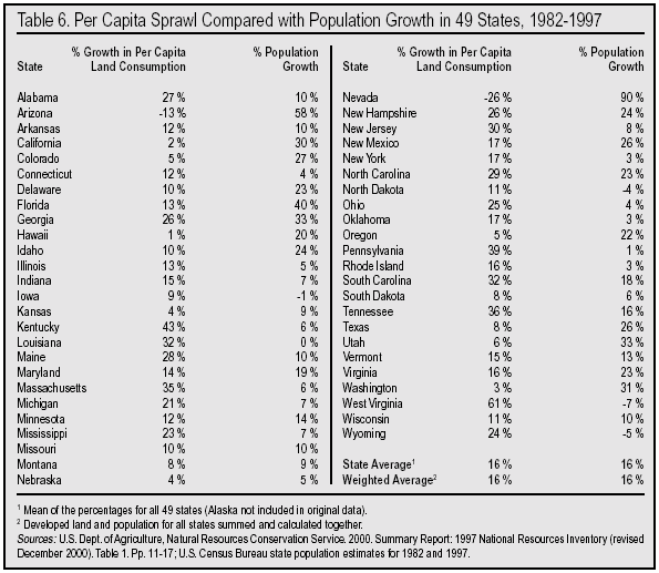
We also find that those states that had higher population growth tended to have less growth in per capita land consumption, i.e. less Per Capita Sprawl. For example, the 10 states with population growth of 25 percent or more averaged only a 4 percent rise in per capita land consumption that compared to a 16 percent rise in per capita land consumption averaged for all 49 states.
There could well be a correlation between higher population growth and lower Per Capita Sprawl, perhaps due to greater regulation and land use planning that become politically feasible with intense population pressure, and that have the net effect of pushing up densities in an effort to limit sprawl. It also could be that the construction and development industry are not able to keep pace with rapid population growth, which means that per capita land consumption may eventually rise when industry has had more time to respond.
Combining the data of all 49 states, we find that growth in both population and per capita land consumption occurred at the same rate 16 percent over the 15-year period of 1982-1997. We find a similar result when combining data for all 100 of the Census Bureau's largest Urbanized Areas. Those results are summarized in Figure 3. Overall population growth in these cities from 1970-1990 was 23.6 percent and their Per Capita Sprawl or per capita land consumption growth was 22.6 percent. Thus, it is evident that the roles of the two growth factors are nearly identical in both the states from 1982-1997 and in the largest cities from 1970-1990.
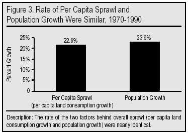
Scatter Plot of Population Growth and Sprawl. One of the most common and straightforward ways of examining the relationship between two variables is to use what is called a scatter plot. Figure 4 is a scatter plot of the increase in each state's population (1982-1997) on the x (horizontal) axis and percent sprawl (1982-1997) on the y (vertical) axis. The scatter plot also shows a straight line, which represents the "best fit" to the data points. That is, the line smoothes out fluctuations in the data and shows the pattern or relationship between population growth and sprawl more clearly. The upward or positive slope of the line indicates that there is a positive relationship between population increase and sprawl states with more population growth are also states where more land was developed. If the contention of some observers that sprawl and population are unrelated was correct, then the line should be flat or even negative. This is clearly not the case. Of course, the scatter plot does not conclusively prove that population growth causes sprawl, but it does strongly suggest the two are closely related.
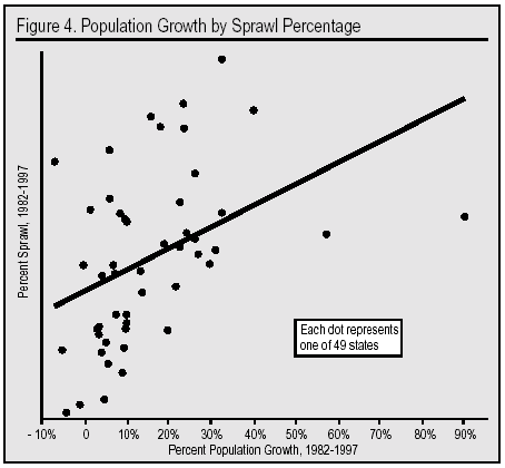
Scatter Plot of Per Capita Increase in Land Use and Sprawl. Population growth is not the only factor affecting sprawl. As already discussed, increases in land use per-person must also play a role in the expansion of developed land. Figure 5 shows a scatter plot with percent sprawl again on the y-axis, but instead of population growth on the x axis as in Figure 4, the increase in per capita land use is substituted. The positive slope of the line indicates that increases in land use per person are also positively correlated with sprawl. Taken together, Figures 4 and 5 indicate that both factors are important reasons for sprawl.
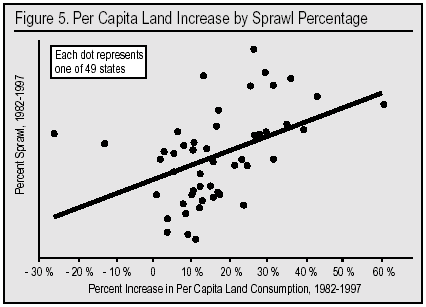
Top- and Bottom-Ten Sprawling States. Another simple way to examine the relationship between population growth and sprawl is to examine the amount of population growth exhibited by those states that sprawled the most and the least. If population growth were not an important underlying cause of sprawl, one would expect that states which sprawled the most would have very similar rates of population growth as states that sprawled the least. In fact, the opposite is true. Increases in developed land are associated with population growth:
- In the 10 states that had the largest percentage increase in developed land between 1982 and 1997, population grew on average by 19 percent.
- In contrast, the 10 states that had the smallest percentage increase in developed land had population growth averaging only 4 percent.
States that sprawled the most grew dramatically more in population than those with the least sprawl. By itself, of course, this does not prove that population growth is an important underlying cause of sprawl. But it certainly indicates that where there is a great deal of sprawl there is also a great deal of population growth.
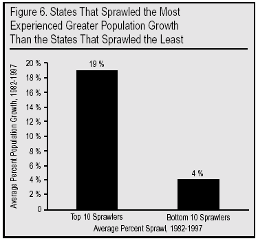
The Impact of Population Growth and Density Changes on State Sprawl
The discussion above examines population growth in areas that have experienced a lot or relatively little sprawl. If we look at this question in the opposite direction we again find a strong relationship between sprawl and population growth. For example, in the 44 states with population growth between 1982 and 1997, the average increase in developed land was 34 percent. In contrast, in the four states with population decline, developed land increased by only 20 percent on average. Even the 20 percent figure is misleadingly high because it reflects a 50 percent development increase in West Virginia, which is an anomaly.178 While West Virginia ranks high in sprawl, the other three states with population loss rank 43rd, 48th and 49th in the amount of lost undeveloped land. Wyoming had a 17 percent increase in developed land, Iowa an 8 percent increase and North Dakota a 6 percent increase, for an average of 11 percent, compared with the 34 percent for states where population grew.
Population Is Closely Associated with Sprawl. Figure 7 shows the relationship between population growth and sprawl by separating the states that had population growth according to their rate of growth. The figure shows the same general pattern as in the above discussion:
- As we have seen, in the four states in which the population declined, developed land increased 20 percent on average.
- Of 22 states that grew in population by between 0 and 10 percent, developed land increased 26 percent on average.
- In the seven states with population growth of more than 10 percent and less than 20 percent, there was a 38 percent expansion in developed land on average.
- In the 10 states with population growth of more than 20 percent and less than 30 percent, there was 41 percent expansion in developed land on average.
- In the six states that grew by more than 30 percent, there was 46 percent expansion in developed land on average.
Population growth appears closely associated with sprawl. In general, the more a state grows in population, the more land that is lost to development. Of course, these figures also show that even where there is population decline, there is still sprawl, indicating that increase in population is certainly not the only reason for sprawl.
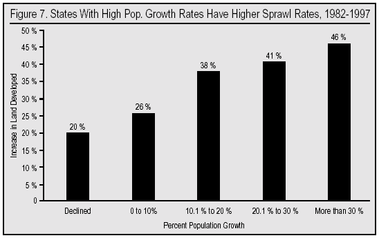
Ranking the States by Absolute Population Growth. Ranking the 49 states based on total population change and not percentage change in population confirms yet again the striking positive relationship between population increase and expansion of developed land. If the states are ranked by absolute population growth from highest to lowest, then divided into three groups we get the following results:
- The top third averaged population growth of 1.7 million from 1982 to1997 and lost on average 871,200 acres to development.
- The middle third had population growth averaging 365,707 and lost on average 393,619 acres.
- The bottom third had population growth averaging 56,000 and lost on average 229,000 acres.
Arizona and Nevada: Success Stories? Another way to think about the relationship between population growth and the expansion of developed land is to look at states in which land use per person actually went down. That is, there was no Per Capita Sprawl. There were only two states where land use per person decreased between 1982 and 1997 Arizona and Nevada. This is a goal of the Smart Growth movement. So in effect, these states should be a real success story. But in both states, the amount of sprawl was enormous. Arizona experienced a 40 percent increase in total developed land while Nevada's increase was 37 percent. These two states can hardly be described as success stories if the goal is to preserve open space and protect undeveloped land.
Both states had such high population growth that it negated the gains from a reduction in per capita consumption, with the result that an enormous amount of land was lost to development. Arizona's per capita land consumption declined by 13 percent, but with massive population growth of 58 percent the state suffered the loss of 629 square miles of undeveloped land. Nevada reduced per capita land consumption by 26 percent but still lost 171 square miles to development. The lesson of Arizona and Nevada is that if there continues to be dramatic increases in population, controlling the density of new settlements by itself will not prevent very high rates of sprawl.
Land Use and Population Both Matter. All of the findings in this section indicate that population growth is an important underlying cause of sprawl. Of course, our analysis makes clear that increases in per capita land consumption also play a role. Thus, the Smart Growth movement is correct to focus on factors that would reduce land use per person. Nonetheless population growth also seems to be central to understanding the loss of rural and undeveloped land. To focus exclusively on per capita land use as the movement has largely done, however, is almost certainly not going to prevent massive loss of rural and wild land.
Population Growth's Share of Sprawl
Even though the above analysis makes clear that population has played a central role in sprawl, so far we have not attempted to quantify its role in contributing to the expansion of developed land. The side-by-side comparisons in Tables 5 and 6 of the percentage growth in each sprawl factor make it clear which is the more important in any state and although such a comparison offers a general sense of the ratio between the two some observers may wish for precise figures quantifying the relationship. That is, some may want to know, "What percentage of a state's encroachment on undeveloped land is related to population growth and what percentage is related to increased per capita land consumption?"
Quantifying the Role of Population Growth. Since both sprawl factors together account for 100 percent of the sprawl in each state or city, the exercise in this section will merely convert the relationship between the two sprawl factors into two percentages that will add up to 100. As a result of this exercise, we will be able to say that around 44 percent of the sprawl in Georgia is related to increases in per capita land consumption and that around 56 percent of the sprawl is related to population growth. This is merely a mathematical way of expressing the relationship we already could observe when looking at the 26.2 percent growth in per capita land consumption and the 32.5 percent growth in population.
We will use two statistical methods to calculate the relationship. Both are based on a simple equation. As already mentioned, and as explained more fully in Appendix D, the amount of land taken up by a city, town, metropolitan area, developed area, or urbanized area is the simple product of the number of residents times the amount of land used (or consumed) per resident, as shown in the following equation:
A = (P) * (a)
Where:
A = Area of urbanized/developed land in acres or square miles
P = Population of the urban/suburban area or state
a = developed or urbanized land per person (i.e. the inverse of density, which is number of people per unit area of land)
Sprawl then is the increase of A over time.
The Simple Ratio Approach. A simple way to calculate the ratio of any two figures to each other is to add them together to obtain a sum, which can then be divided into each figure to yield two percentages. The two percentages thus obtained will add up to 100 percent. We call this the "simple ratio" method. For example, in the case of Georgia, we add the per capita consumption growth percentage of 26.2 to the population growth percentage of 32.5, yielding a sum of 58.7 percent. When we divide 58.7 into each growth figure we find that:
- The 26.2 percent growth in per capita consumption is 44 percent of the power of the two growth figures combined (26.2 / 58.7 = 44 percent).
- The 32.5 percent growth in population is 56 percent of the power of the two growth figures combined (32.5 / 58.7 = 56 percent).
Based on that, we can say that 44 percent of Georgia's sprawl is explained by, or related to, per capita consumption growth, and that 56 percent of Georgia's sprawl is explained by, or related to, population growth.
Simple Ratio Analysis of States. Applying the "simple ratio" to states in Table 7 we find a great deal of variation from state to state in the source of sprawl: In six states (Iowa, Louisiana, North Dakota, Pennsylvania, West Virginia, Wyoming) 90 percent or more of the sprawl is related to declining population density (that is, rising per capita land consumption). In five other states (Arizona, California, Hawaii, Nevada, Washington) at the opposite end of the spectrum, 90 percent or more of the sprawl is explained by population growth. The first group of six states has experienced relatively low population growth (or even "negative growth") while the latter group of five states has undergone explosive growth in the number of residents. The six high per capita sprawl / low-population growth-states converted 3,305 square miles of rural to developed land in the 15 years from 1982 to 1997. The five low Per Capita Sprawl / high-population-growth states lost 3,733 square miles of rural land over the same time period. We find that in the average state (the mean of the 49 state percentages), per capita sprawl explained 55 percent of the new land development, while population growth explained 45 percent.
When calculating all the states population growth and land consumption growth together (the weighted average), we find that 50.3 percent of new land development is related to per capita sprawl and 49.7 percent to population growth. (Both are rounded to 50 percent in Table 7.) From this, one can easily say that roughly half of the increase in developed land in the 49 states from 1982 to 1997 was related to increase in land consumption per state resident, and half to the increase in the number of state residents.
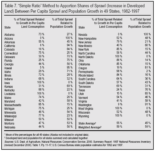
It should be pointed out that while the percentage figures themselves are exact, this does not mean that actual sprawl corresponds precisely to these percentages. For example, it is unlikely that all sprawl (100 percent) is due only to population growth in Arizona and Nevada. Certainly there are places within these two states where sprawling, low-density subdivisions have indeed eliminated desert and cropland. Our analysis of Census and developed land data strongly suggests that in such cases, the overwhelming preponderance of sprawl is due to population growth. Conversely, even in those states that lost population overall from 1982-1997 (Iowa, Louisiana, North Dakota, West Virginia, Wyoming), and which thus show 100 percent of sprawl related to "per capita sprawl," there are certainly places in which population growth has played some role. But in these states as a whole, it's a negligible one.
The Holdren Method. Apportioning shares of sprawl or the rate of sprawl between rising per capita land consumption (declining population density) and population growth can also be accomplished by means of applying a more mathematically rigorous method first described and partially developed by Harvard physicist John Holdren, internationally honored in 2000 for his achievements in environmental science.179
This method can be applied to virtually any type of resource use. Perhaps its best-known application has been in understanding how total U.S. energy use has risen in recent decades. The method enables analysts to apportion shares of the total rate of increase of energy consumption in a state, country, or the world as a whole to (1) the change in per capita energy use and to (2) the change in population.
The Holdren method can also help us understand how much of the sprawl rate is related to declining population density, or rising per capita land use, and how much should be attributed to population growth. As in the case of national energy consumption, the question here is how much of the increased total consumption of rural land (Overall Sprawl) is related to per capita change in land consumption (per capita sprawl) and how much is related to increase in the number of land consumers (population growth). See Appendix E for further description.
For all the complexity of this method and its use of logarithms, it produces only slightly different results in Table 8 than the ones in Table 7 from the more transparent calculation explained above (the "simple ratio" method).
For now, we will simply provide the equation from the Holdren method that we use to determine the percentages brought about by rising population and falling density:
Population's share of growth rate = Annualized average population growth rate / Annualized average land development growth rate
The term "annualized" means that the natural logarithm (ln) is applied to the rate of increase in each of the factors. This avoids the distorting effect of what is called in mathematical parlance a "second-order term."
Another way of expressing this mathematical relationship is the following:
ln (final population / initial population) +
ln (final per capita land area / initial per capita land area) =
ln (final total land area / initial total land area)
Once these numbers are obtained, to find the percentage of the growth rate due to either population or density, either factor can simply be divided by the land area factor (and multiplied by 100 to convert to percent). For a more complete explanation, please refer to Appendix E.
Holdren notes that this kind of numerical analysis cannot reveal the whole, complex story of population's role in rising energy consumption, because of "nonlinearities." That is, in the numerical equation, population and per capita consumption are treated strictly as if they were separate, independent variables, when in fact, in the real world, they may interact with each other. In other words, they are likely to be interdependent in many cases. For instance, per capita energy use may depend on population size or growth rate, and so forth. But teasing these complexities apart in an effort to quantify them is all but impossible.
Analogously, in a number of sprawl cases there is probably some degree of interaction between the amount of total urbanized or developed land, per capita land consumption, and population size or growth rates. Overall sprawl is not entirely a dependent variable, and per capita land consumption growth and population growth are not entirely independent variables. For instance, high rates of sprawl under the pressure of rapid population growth probably generate political pressure to implement more stringent land use controls and zoning, which may lead to higher residential densities than would occur otherwise.
In general though, this numerical analysis allows us to quantify, with fairly high confidence in the broad accuracy of the results, the relative strength of the two factors per capita land consumption and population in forcing urban sprawl and land development.
Holdren Method Analysis of States. Table 8 reports the results of the Holdren method using the state data. In comparison to the simple ratio method found in Table 7, the results in Table 8 obtain very similar results when looking at the nation as a whole. The state average (mean) for the two methods produces identical results: 55 percent of overall sprawl related to per capita consumption and 45 percent related to population growth. The weighted averages (obtained by aggregating the figures for growth in population and developed land for all 49 states) are very close for both methods. In the simple ratio method, the weighted average shows 51 percent of total sprawl related to per capita consumption, and 49 percent to population growth. In the Holdren method, these percentages are essentially reversed 48 percent for per capita sprawl and 52 percent for population. Overall, analysis of the NRI data on increase in developed land for 48 contiguous states plus Hawaii from 1982-1997 strongly suggests that per capita sprawl (rising land consumption per person) explains roughly half of sprawl, and population growth the other half.
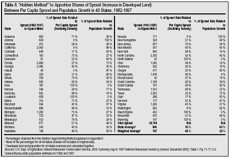
Regression Analysis of State Data. While the "simple ratio" and "Holdren" formulas above are very useful for apportioning the total amount of sprawl attributable to changes in per capita land use or population growth, they do not provide an estimate of how much land is actually lost to development, holding other factors constant. For example, the developed area of California and Vermont expanded by roughly the same percentage (32 percent and 31 percent, respectively) between 1982 and 1997. However, because California had a much larger developed area to begin with, its 32 percent expansion was 2,060 square miles while the 31 percent increase for Vermont was only 117 square miles. In order to address this question, we performed a regression with the state data. While regression is a very different approach than that utilized in the this study so far, the results that follow buttress the above analysis by showing the importance of population growth as a cause of sprawl, even after controlling for other factors.
The Ordinary Least Squares (OLS) regression model takes the following form:
Acres lost to development 1982-97 in 1000si =
where is state population in 1982; is change in state population 1982-97; is acres of developed land in 1982; is per capita land use in 1982; is change in per capita land use 1982-97 and is an error term.
Results of Regression Using State Data. Table 9 reports the results of the regression. All of the variables are significant at the 0.01 level. The high R-squared indicates the strength of the statistical model. Turning to our variable of interest, population growth, we find that it behaves as expected. The results show that each 10,000-person increase in state population between 1982 and 1997, resulted in 1,600 acres of previously undeveloped land being developed. This is the case even after controlling for other factors such as the initial size of the state's population or the total land area that was developed at the start of the time period in 1982. Also as expected, Table 9 shows that changes in per capita land use accounted for a good deal of the increase in developed land. For each 1,000-acre increase in the amount of developed land used per 10,000 people, 256 acres were developed within a state over the time period of the study. Overall the regression results lend strong support to our earlier findings indicating that population growth is an important underlying reason for sprawl.
Population Growth & Sprawl Analysis of City Data
So far we have examined only the state data. However, the nation's largest urbanized areas also provide an important source of additional information on the role of population in creating sprawl. Although the urbanized area data measure sprawl in a different way than the state data, the results below lend strong support to the conclusion that population growth is a critically important part of the sprawl equation.
Population Growth in the Worst and Least Sprawling Cities. Table 10 reports the average population growth for cities with the largest and smallest percentage increases in urbanized area (sprawl). Tables with all data for the 100 largest Urbanized Areas can be viewed on-line at http://www.sprawlcity.org/hbis/index.html. As in the case of states, this exercise shows that increases in urbanized area are associated with population growth. Probably the starkest contrast can be found by comparing the top-10 worst sprawlers with the 10 cities that sprawled the least. In the 10 worst cities, population grew by 103 percent on average between 1970 and 1990. In contrast, in the 10 cities that sprawled the least, population grew by only 7 percent on
average.
The same general pattern exists if we look at the top and bottom five sprawlers as well and the top- and bottom-20 sprawlers. While other factors surely have also played a role, it is clear that those cities that expanded the most in size had dramatically higher levels of population growth than those cities that expanded the least. On its face, this indicates that there is likely to be a causal relationship between population growth and sprawl.
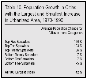
The Impact of Population Growth on City Sprawl. Table 11 examines the relationship between population and sprawl from the opposite direction as Table 10. Of the 100 Urbanized Areas examined in this study, 11 declined in population, while 89 experienced population growth between 1970 and 1990.
In the 11 cities that declined in population, urbanized area increased in size by 26 percent on average. This means that the density of these cities (land per person) fell, and the built-up area expanded. Thus, even without population growth there is still significant sprawl.
However, the expansion in urbanized area in cities that declined in population was modest in comparison to the 89 cities where population increased. The built-up area of cities that grew in population expanded in size 75 percent on average or almost triple that of the 11 cities that declined in population.
The relationship between sprawl and population growth holds for cities with differing levels of population growth; with more population growth comes more sprawl. In the 16 cities that grew in population by 10 percent or less between 1970 and 1990 (but whose population did not decline), urbanized area expanded 38 percent more than in cities that declined in population but considerably less than in the cities where population increased more dramatically. Cities that grew in population by between 10 and 30 percent sprawled 54 percent on average. Cities that grew between 31 and 50 percent sprawled 72 percent on average. Cities that grew in population by more than 50 percent sprawled on average 112 percent. These findings confirm the common sense, but often unacknowledged proposition, that there is a strong positive relationship between sprawl and population growth. This relationship is depicted graphically in Figure 8.
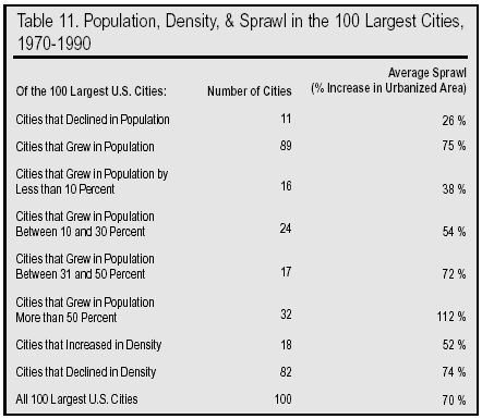
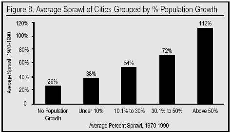
Denser Settlement Did Not by Itself Prevent Sprawl. A central goal of Smart Growth is to slow or even stop the conversion of rural and less developed areas to urbanized land by preventing a decline in density. Thus places where density increased should be the success stories. Between 1970 and 1990, there were 18 cities where the density of their urbanized areas either remained the same or increased (another way of saying that the per capita land consumption declined). However, these cities experienced very significant sprawl. As the bottom of Table 11 shows, the urbanized area of these 18 cities, which reduced per capita consumption by increasing density, expanded 52 percent on average into the surrounding rural area. The reason these 18 cities sprawled so much despite an increase in density is that their population grew even faster than did their density. The population of these 18 cities increased 86 percent on average, while density increased only 17 percent. As a result, these 18 cities encroached on rural and undeveloped areas at a 52 percent rate, less than the average city which sprawled 70 percent, but considerably more than the 26 percent increase in cities that experienced population decline.
Applying the Holdren Method to the Urbanized Areas. As we have seen, the Holdren formula can be used to apportion the amount of sprawl related to increases in land use per person and increases in population. Using this approach reveals results very similar to those of the analysis done on the states, with roughly half (52 percent) of sprawl related to population growth and 48 percent related to increases in per capita land use.
Taking the measure of all cities and states analyzed, population growth accounts for slightly more than half of sprawl in the nation's cities, and somewhat less than half in the nation's states. In sum, it would appear that population growth accounts for about half of sprawl. The other half of sprawl reflects an increase in land per resident, which itself is the outcome of at least two-dozen factors. Thus, it is reasonable to conclude that of the dozens of factors contributing to sprawl, population growth is the single most important. It is also reasonable to conclude that population growth has approximately the same influence on sprawl as all the other factors combined.
There Is Great Variation in the Reasons for Sprawl from Place to Place. As Table 11 indicates, there is tremendous variation in the percent of sprawl due to population growth vs. declining density in the nation's 100 largest urbanized areas between 1970 and 1990. In 18 of the cities, population growth accounted for 100 percent of sprawl. In 11 cities, population growth accounted for 0 percent of sprawl. In the remaining 71 cities, some combination of population growth and declining density was responsible for sprawl. Thus focusing on just one factor such as density or population growth cannot solve the problem. Clearly a multifaceted approach that addresses all of the causes of sprawl is necessary.
Policy Implications
Necessity of Tackling Both Major Sprawl Factors
Local, state, and national officials who want to greatly reduce the urbanization and development of rural land must adopt a two-pronged attack. They will have to address both the consumption factor and the population factor. This study's examination of data from the U.S. Natural Resources Conservation Service and from the U.S. Census Bureau marshals strong and broad evidence from multiple analyses of two distinct and reliable data sources to show that sprawl in this country cannot be substantially stopped without a two-pronged attack.
The oft-heard assumption of many advocates of the Smart Growth movement that population growth is only a minor or inconsequential factor in the conversion of rural land to development is shown to be false.
Although such a contention is true in several urbanized areas and in a few states, it is not true in the overwhelming majority of cities and states, where population growth is a significant factor or the primary factor in sprawl. And in the country as a whole, roughly 50 percent of all losses of undeveloped land appears to be related to population growth.
Expressed more dramatically, the analyses in this study suggest that population growth has about the same impact on sprawl as do all other factors combined. To neglect the population factor in the anti-sprawl fight would be to ignore essentially half the problem.
At the same time, one must be careful not to overstate the role of population growth or to over-promise what U.S. population stabilization would bring. Under current conditions, even if all population growth were stopped, farmlands and wildlife habitat around the nation's cities would continue to suffer large amounts of sprawl. Local, state, and national governments desiring an end to sprawl must work on stopping the factors that increase the developed land per person, as well as factors that increase population. This study disproves the contentions of certain "population hawks" that problems like sprawl could be largely resolved if the country would just stabilize its population.
Focusing on only one set of factors appears to guarantee failure in stopping sprawl. Even with a successful single-pronged approach, cities will sprawl just as far; it simply will take them longer to get there.
Some earlier studies have failed to discover the necessity of the two-pronged approach because they did not focus on elimination of rural land the permanent removal of farmland and natural habitat through the process of urban and other development. Instead, they focused on esthetics, efficiency, order, capital and operating costs to local governments, and other urban-planning criteria. While those other aspects of sprawl are legitimate and important, the actual loss of farmland and natural habitat and the never-ending expansion of our cities are among the greatest reasons Americans are clamoring for public policies to combat sprawl. And they are the main reasons why sprawl is so damaging environmentally. Hence, this study focused on quantifying that urban growth spreading out over rural land. Whether the development was attractive or ugly, well-planned or chaotic, densely populated or sparsely populated, did not matter in this study, which objectively stuck to analyzing actual acres of lost rural land.
Once public officials focus on actual loss of rural land, they cannot avoid the importance of population growth this study has found. Interestingly, this is not the first study to analyze sprawl's relationship to population.
The findings of this study are in line, for example, with those of President Clinton's Council on Sustainable Development. It declared in 1996 that environmental sustainability in this country is not possible without U.S. population stabilization. Sprawl is one of the environmentally unsustainable trends of this country. The President's Council recommended that the country "move toward stabilization of U.S. population," a recommendation that this study found will provide great relief from sprawl.180180
Local Influence on Population Growth. Local and state officials who take seriously the findings of this study and the desire of citizens to dramatically curb sprawl have a number of tools to reduce population growth in their jurisdictions.
To wield such tools would require officials to go against a Babbitry strain of American polity that runs through our entire history the desire of nearly every mayor and governor to preside over a larger and larger population that qualifies for more and more state and federal dollars and that enjoys greater visibility and clout on the national scene; the desire of nearly every newspaper publisher to have a never-ending increase in potential subscribers and in consumers for the businesses buying ad space. While various polls have suggested that most Americans would prefer that population growth in their communities stop or dramatically slow down, many public officials claim bragging rights for successfully promoting exactly the opposite outcome.
Local officials and the people they represent are in a tug of war over sprawl. This study shows that it is not possible for the public to achieve the victory it desires over sprawl if local officials continue to subsidize and entice local population growth. While most Americans appear to prefer less or no population growth in their locales, there are indications that the prevailing sentiment among local and state officials is to back policies that encourage higher population regardless of what it does to the per capita standard of living and quality of life of the residents they serve. To these officials, population growth is an intrinsic public good that nearly always must be pursued. This can be seen in urbanized areas like Pittsburgh, which benefits from a stabilized population by having no population-induced sprawl and having overall sprawl that is far below the national average. In such cities, many civic leaders clamor for ways to boost the population. They offer subsidies and tax breaks to lure companies to locate there and they advocate population growth inducements even through enticing low-wage foreign workers who require more public subsidy than other kinds of population growth.181 A growing body of literature has explored the forms of public subsidies for local population growth. A recent study by sprawl expert Eben Fodor for a group called Alternatives to Growth Oregon attempted to quantify the amount of subsidy each year to entice population increase and land development. The Fodor study is particularly interesting because it finds such large subsidies of growth in a state that may very well be the nation's leader in trying to control growth.182
The study found that in the year 2000, Oregon taxpayers were forced to provide $738 million in uncompensated infrastructure subsidies for new growth. This included the costs of additional roads, sewage treatment, fire stations, libraries, schools, etc. A recent survey showed that 73 percent of Portland-area residents believe that new development should pay all of those costs so that the public provides no subsidy.183 When total public subsidies were calculated, Fodor estimated a $1.14 billion net taxpayer expense for enticing more of the population growth that is driving most of the Oregon sprawl that the public detests.
Removing these giant taxpayer subsidies to local growth and forcing the purchasers of newly developed land to pay the true costs of that development would surely decrease the number of newcomers into a town, at least for the short run. It would also have the effect of deflecting the population growth to other towns or areas.
National Influence on Population Growth. In other than the very short-term, local and state officials can only be so successful in slowing population growth in their jurisdiction if the national population continues to grow by more than three million people a year.
Those 30 million and more new Americans each decade will nearly all settle in some local community, even if every one of the communities stops subsidizing population growth.
As was noted above, there are three sources of our national population growth native fertility (in conjunction with increasing lifespans), immigration, and immigrant fertility. We know this about their contribution to long-term growth:
- Native fertility remains well below replacement level and has not been a source of long-term U.S. population growth since 1971.184
- Immigration and immigrant fertility (births to foreign-born mothers), on the other hand, are far above replacement level and the sole source of long-term population growth in the United States.185
Nearly all long-term population growth in the United States is in the hands of federal policy makers who have quadrupled traditional annual immigration numbers to an average of a million a year since 1990 and allowed illegal migration to rise to more than 700,000 permanent settlers a year.186
As long as the federal government pours that volume of population growth into the nation, most local communities are going to experience sprawl regardless of local disincentives for population growth.
Federal Immigration Policies: No. 1 Force in U.S. Sprawl
Because present immigration levels and immigrant fertility are generating nearly all long-term U.S. population growth and are responsible for about two-thirds of current short-term growth, it appears on the surface that federal immigration policy is the single most influential policy in dealing with sprawl.187
The policy implication would be that long-term success of local communities in combating sprawl is heavily dependent on whether the federal government decides to stop forcing massive population growth through elevated levels of immigration.
It is not possible to create a precise ranking of the two-dozen or more factors that increase per capita land consumption. But each of them can claim only a small fraction of the roughly 50 percent of sprawl that is related to per capita consumption growth. The other 50 percent of sprawl, however, is related to population growth and is divided only two ways between native fertility and immigration (new immigrants and immigrant fertility). New immigrants and immigrant fertility account for the majority of U.S. population growth. Thus, it would appear that immigration is a far larger factor in sprawl than any other.
Although the above logic makes sense statistically, personal knowledge about this era's immigrants causes many people to doubt that immigration could really be a significant factor in sprawl.
A common perception about immigrants is that they are poor and dwell at high-density levels in the nation's urban cores. How can a people who crowd into the inner cities be held responsible for sprawl on the outskirts? When immigration is publicly blamed for increasing sprawl, it is not uncommon to see letters to the editor appear in local newspapers arguing that it is not densely-clustered, apartment-dwelling immigrants but hyper-consuming American natives who build the big houses in the suburbs, who build the freeways to access them and the strip malls to service them, and who use up all the land.
Growth from Immigrant vs. Natives. The hypothesis that often is advanced suggests that although population growth from American natives causes sprawl, population growth from immigration does not. That hypothesis is challenged by the four primary ways that population growth from immigration causes sprawl:
- Direct settlement by immigrants in the suburbs;
- High fertility creates larger second generation of households, and children of immigrants desert urban cores by higher margins;
- Immigrants facilitate movement of natives to outer edges;
- Natives flee immigrant concentrations.
Direct Settlement by Immigrants in the Suburbs. Perceptions are heavily colored by the behavior of immigrants when they first arrive. Indeed, new immigrants are nearly twice as likely to live a central city as are natives.188 Nonetheless, Census data reveal that even among new immigrants, the majority (56 percent) live outside the central city of a metropolitan area where the sprawl occurs. As a 2000 article in Preservation magazine noted: "Suburbs are on their way to becoming the most common place of residence for Hispanic Americans and Asian Americans, the groups that make up most of the country's foreign-born population."189
From the large Mexican community in the Washington, D.C., outer suburb of Manassas, Va., to the Hmong of California's Central Valley and the Somalis of Fargo, N.D., recent immigrants are settling outside America's core cities. As two sociologists remark with regard to contemporary immigrants: "For these newcomers, the port-of-entry to the American Dream is more likely to be the suburban arches of McDonald's than the smoke-stacks of a downtown factory."190 With more than a quarter of all adult immigrants holding a college degree and participating heavily in well-paid professions, it should not be surprising to find them well-represented among the home-builders and home-buyers pushing the urban edge into pastures, fields, woods, and wetland. In the Washington, D.C., metropolitan area, for example, 89 percent of immigrants lived outside of the District of Columbia, according to the 1990 Census.191
It should not be surprising to find that most immigrants want to live like Americans. The predominant motivation of immigrants in coming to America is to increase their consumption to American levels; they leave family, home, country, and culture to move to the United States in order to consume more food, education, health care, consumer goods, housing, and land. The American Dream is most commonly described in terms of increasing their standard of living not living packed in apartments so as to protect more open space or riding in a bus to reduce traffic congestion and air pollution instead of owning and driving a car as soon as they can afford it.
Immigration may help explain part of the reason why average commuting times across the country are increasing so rapidly, according to a 2003 Christian Science Monitor report. "Immigration is the great wild card," said Alan Pisarski, a travel consultant and author of Commuting in America. "I'm seeing the impact of immigration on almost everything."
Robert Lang, director of the Metropolitan Institute at Virginia Polytechnic Institute, indicated that immigration is contributing to increasing traffic congestion because the fast-growing foreign-born population is moving quickly to the suburbs and because "immigrants are moving very quickly from public transportation to cars." Immigrants start behaving like Americans as fast as they can. Whatever high-consumption, environmentally damaging lifestyle the average American may have will be multiplied millions of times a decade by the arrival of millions of immigrants because each of them, on average, will largely emulate American consumption patterns.192
Immigrant families move to the outer edges for the same reason so many native families do cheaper rents, more square footage and bigger yards for the money, and the perception of more safety for their children. The fact that most immigrants make considerably less money than natives actually increases the pressure on them to live in the outer fringes in many areas such as Atlanta because that is where land, houses, and apartments are cheaper than in most of the rest of a metropolitan area and also because their jobs are in those outlying areas. The Los Angeles Times reported that growing numbers of immigrants in California are skipping even the outer edges of the metropolitan areas and creating population booms in rural areas in part because of the perception that "compared with gang- and drug-infested inner-city neighborhoods, even end-of-the-road farm hamlets are preferable."193
High Fertility Creates Larger Second Generation of Households. Because immigrants have a fertility rate that is at least 40 percent higher than that of American natives, the children of immigrants are an even more important cause of sprawl than the immigrants themselves.194 While American natives have a "sub-replacement" fertility rate around 1.9 that creates a slightly smaller size of each succeeding generation, the high average fertility of immigrant families produces larger succeeding generations.195 The Total Fertility Rate (TFR) for Hispanic foreign-born women (a large majority of new female entrants each year) is around 3.2.196 Thus the second generation is substantially larger than the first generation of immigrants and requires more housing and places to work, shop, and recreate.
The children of immigrants have another increased direct impact on sprawl: They grow up with even stronger desires than the original immigrants to live outside the core cities. In many cities, the largest flow in the exodus from core city to suburbs may be the children of immigrants.
Only 31 percent of adult children (21 and over) of immigrants live in the nation's central cities. This falls to 28 percent for those over age 35 and compares to 27 percent for all American natives. For the children of immigrants who have settled down and purchased a home only 24 percent have done so in the nation's central cities.197
Thus, assimilation to the American land-consumption patterns appears to be complete by the second generation. The children of immigrants shun core-city living in the same proportion as natives. This points to one of the great weaknesses of American core cities: Many of them are places that not only fail to attract as many American natives to live in them as move out, but they cannot attract even half of the mostly third-world immigrants.198 And, of the immigrants they do entice to live in their neighborhoods, those core cities cannot hold onto a significant part of their children once they become adults. Until American core cities become places where American natives whether the children of immigrants or of natives want to live, the land in those cities will be underutilized and urban flight will continue to be a major source of sprawl.
Immigrants Facilitate Movement of Natives to Outer Edges. Immigration can facilitate the movement of natives to the suburbs in two ways.
First, immigrant home-buyers purchasing homes from natives enable the latter to liquidate their fixed assets in urban cores and reinvest in suburban homes. Except for the most wealthy of natives who build new homes at the edge of urban areas, they would not be able or willing to finance the new construction if there were not buyers for the homes where they previously lived in the core cities and existing suburbs.
This concept might appear to be contradicted in the urbanized areas that had significant sprawl despite having no population growth, and even population decline. The Pittsburgh Urbanized Area, for example, lost 9.1 percent of its population between 1970 and 1990 and had little immigration but still sprawled by 30.5 percent. Nevertheless, this rate of sprawl was still far less than for other cities; in fact, cities that experienced population growth sprawled three times faster than did Pittsburgh.199 But with no population growth in Pittsburgh, who was buying the old homes and moving into the old apartments to enable so many people to build new homes beyond the urban boundaries?
The primary answer is found by looking at changing household size. The average household nationwide became 16 percent smaller between 1970 and 1990. Thus, even if the population of an average city remained exactly the same, it would need roughly 16 percent more housing units to accommodate that same size population. It is reasonable to assume that, all other things remaining the same, an urbanized area like Pittsburgh would sprawl around 16 percent just in response to the 16 percent decline in household size and the resulting increase in households per 100,000 population. It would not have to sprawl that much if at least some of the extra households could be provided new housing in undeveloped or underdeveloped parcels in the existing urban area. But the existing patterns of development would have had to change. Without change, the decline in size of households would create sprawl.
The causes of the decline of American household size are many. They include increased ratio of home-buying adults to dependent children in the population, an increased divorce rate, fewer children in families, delayed age of marriage, the financial ability and the will for unmarried adults to live apart from their parents and in single households rather than group households, and the increased longevity of senior adults who often are widowed or otherwise single and who rarely have children in the household.
Over the long-term, smaller households should be able to live in smaller houses and apartments. It should be possible to have more households per square mile. But over the short-term, the exact opposite often occurs. When a couple divorces, for example, one adult stays in the previous home and the other usually moves into another. In another example, a person may die and the surviving spouse might occupy the same home space. For declining household size not to create sprawl while the population remains the same or is growing, the remaining divorced spouse would need to build another dwelling in the back yard, or the surviving widow(er) would need to sub-divide the apartment. The number of households per square mile of city would have to increase. In reality over the short-term, though, that kind of major in-filling and sub-dividing has not occurred, and the additional households created by declining household size have caused new dwellings to be constructed outside of the existing urban boundary.
The second way that high immigration facilitates additional development on the edges of cities while enlarging the size of the new houses and lots is by providing widespread availability of cheap, low-skill labor. This amounts to a transfer of wealth that makes expansive suburban lifestyles more affordable for middle-class natives. This includes everything from construction to landscaping and maintenance. If cheap foreign-born construction and landscaping labor were not available, for example, there would be far fewer people building houses with one-acre to five-acre yards which the owners have no desire to maintain on their own. In fact, the insistence of some affluent suburbanites that they cannot survive without their foreign-born housekeeping, child-rearing, and landscaping labor is one of the pressures on Congress to keep immigration at its high levels.
Natives Flee Immigrant Concentrations. From Dade County, Fla., (the Miami area) to the Greater Los Angeles Basin, large waves of immigration have been responsible for the flight of natives to the suburbs or out of certain regions or states altogether. Neither native-born Americans, nor older immigrants, nor the children of immigrants prefer to live in areas of high immigration. When immigrants first arrive in the United States, they tend to settle disproportionately in the urban cores or older suburbs. Existing residents of those areas whether white, Hispanic, black, or Asian often dislike the cultural changes and instability associated with a heavy immigration influx and move away. Analyzing Census Bureau data on internal migration, University of Michigan geographer William Frey has shown that "immigration exerts a pronounced impact on both the magnitude and selectivity of out-migration from high immigration metro areas."200
In the 1980s and 1990s, natives began moving en masse out of entire regions like southern California and southern Florida, for other parts of the same states or for other states altogether. California experienced an exodus of working-class whites of nearly 100,000 households. Many retirees pulled up stakes from California and headed for Nevada, Arizona, Washington, and Oregon. Numerous whites, in particular, have moved to more rural regions, like the Rocky Mountain West, bringing change and development pressures in their wake.201 Other states with high concentrations of new immigrants also saw net losses of their white populations. "Between 1985 and 1990, New York lost more than a half-million whites in its exchanges with other states; Texas and Illinois lost more than a quarter-million; New Jersey lost nearly 200,000 and Massachusetts lost 114,000."202
Blacks and other minorities have also been forsaking high-immigration inner cities for the suburbs.203 They go in pursuit of affordable housing, better schools, less crime, lower living costs, more elbow room, greenery, and open space. "After decades in which America's cities worried primarily about white flight, cities are now facing the increasingly rapid departure of middle and working class minorities," wrote Karen De Witt in The New York Times.204
Perhaps nowhere has "black flight" been more pronounced than in South-Central Los Angeles, where as recently as 20 years ago residents were almost exclusively African American. As Michael A. Fletcher wrote in The Washington Post, "South Central was synonymous with black Los Angeles."205 An extended quote from Fletcher reveals the anxiety felt by blacks as other groups increasingly displace them:
To be sure, the new immigrants have renewed old neighborhoods, created new businesses and enriched the culture of Los Angeles. But the exploding diversity also has changed the nature of racial conflict and drawn new groups into battles that once were waged almost exclusively between blacks and whites. Here, black and Latino civil servants square off over public jobs. Black activists and Asian storeowners fight over control of local businesses. And Latino and Asian gangs battle for control of their turf.
In Los Angeles, there are suburban developments, such as Monterey Park, that are almost exclusively Chinese.
Nowhere is that more vivid than in the county's South Central corridor, where the number of Latinos is overwhelming the African American population. Much as blacks demanded a fairer share of the power and resources from whites a generation ago, Latinos are now demanding that blacks and others share jobs, special school programs and political control. And like whites before them, many African Americans feel threatened by those demands.
Calling attention to this kind of racial and ethnic discord is not to cast aspersions on any one group. It is not a question of one minority group being in the right and another group being in the wrong. It is simply to acknowledge that rapid cultural and social change can be very uncomfortable or even distressing for anyone, and that tumultuous rates of change in high-immigration American cities since 1980 have led to the massive out-migration of native residents of all backgrounds. Most black Americans from high-immigration zones in Los Angeles who have moved away have gone to places like the San Fernando Valley, and Ventura, Orange, Riverside, and San Bernardino counties, as well as to desert communities even further away.206 Others have gone further yet. Recent Census data confirm that there is a historic migration underway of African Americans back to the urban and rural South.207
Overall Impact of Immigration on Sprawl
Population growth from immigration does not have exactly the same effects on sprawl as does population growth from native fertility, native population momentum, and native migration between urbanized areas. In some ways, immigrant growth causes less sprawl than native growth, and in some ways, immigrant growth causes more. A few examples of these differences include:
- Immigrant growth is less of a cause of sprawl than is native growth because immigrants on average are poorer and consume less.
- Immigrant growth is a bit less of a cause of sprawl because immigrants are a bit more likely to settle in core cities than natives.
- But immigrants are similar to American natives who move into a core city in that they cause sprawl by facilitating construction on the outskirts by purchasing the homes of those doing the constructing.
- Immigrants cause sprawl in a similar way as natives by settling in the suburbs at about the same rate as natives.
- Immigrants are much more a cause of sprawl than natives when it comes to fertility; immigrants produce much larger second generations of households which are just as likely to live outside the core city as natives.
- Immigrants moving into a core city or older suburb are also more of a cause of sprawl than are natives because the presence of immigrants in large concentrations creates cultural change that drives natives and older immigrants away from their existing neighborhoods.
While there are no precise measurements of each of those effects, it should be clear to an objective observer that population growth from immigration produces about the same level of sprawl that one would expect from any kind of population growth.
Conclusion
This study emphasizes the role of population growth because the urban planning approach embodied by Smart Growth already exerts an important influence on the thinking of political leaders, urban planners, the public, and even some developers. Population growth and the immigration policies that drive it exert no such influence on the sprawl debate. To the extent that population is discussed in the context of sprawl it has generally been dismissed as a cause. It is often argued, for example, that since sprawl occurs where there is no population growth, increases in population must be a minor factor in sprawl. As a moment's reflection should reveal, such observations only make sense if one asserts that population growth is the only factor generating sprawl. We make no such argument. Our findings show that population growth is a key factor, but it is by no means the only factor. There are certainly individual places where population growth played little or no role in sprawl, just as there are places where population growth accounted for all of sprawl. But, overall, our analysis shows that nationally increases in population accounted for about half the loss of undeveloped rural land. Thus reducing population growth by reducing immigration must become an important part of any long-term effort to save rural land.
Our conclusion that population growth accounts for half of sprawl is not only consistent with the available evidence, it is also consistent with common sense. Those most directly involved in sprawl certainly believe that population is one of main reasons for sprawl. In fact, the president of the National Association of Home Builders chided the Sierra Club for its 1999 sprawl report because it "failed to acknowledge the significant underlying forces driving growth in suburban America a rapidly increasing population and consumer preferences." Homebuilders and real estate developers are clearly pleased with the high rate of U.S. population growth. But they, of course, have a very different point of view from anti-sprawl organizations as well as most Americans.
Assuming population growth continues to drive about half of all sprawl, as it has in recent decades, federal immigration policy would appear to be the single largest factor in determining how much sprawl will occur over the next 50-100 years. Population growth can only be dealt with effectively on a national scale by reducing immigration because new immigration and births to immigrants now account for most of the increase in the U.S. population. Local efforts to discourage population growth by, say, low-density zoning, will almost certainly result in "leapfrog" development and legal challenges given the population pressure America faces as a result of immigration. Moreover, intensified Smart Growth programs in the face of rapid population growth will increase governmental regulation of land use, erode cherished American freedoms, and almost certainly undermine political support for Smart Growth policies.
While our conclusions may seem obvious to most readers, some may find them controversial. Part of the reason most anti-sprawl organizations ignore population growth is that they are unaware of its role. It is our hope that this study will help correct this. However, some involved in anti-sprawl efforts avoid dealing with population growth because they know that doing so will inevitably lead to a debate over U.S. immigration policy, making it seem as if immigrants are being "blamed" for sprawl. This is something that anti-sprawl organizations understandably wish to avoid. But such concerns seem misplaced since anti-sprawl organizations can make clear that immigration must be reduced due to rapid population increase rather than because of the ethnic characteristics of immigrants. It might also be helpful for such organizations to indicate their support for policies designed to help immigrants already here integrate into American society. Moreover, advocating less immigration in the future for conservationist reasons is likely to be politically popular given that public opinion polls show most Americans, including minorities, want less immigration.
While significantly reducing immigration may be very helpful in reducing sprawl, some may worry that doing so might harm the economy. The available data suggest otherwise, however. A 1997 report by the National Academy of Sciences entitled The New Americans concluded that the net economic benefits from immigration are very small and are, in fact, entirely outweighed by the fiscal drain immigrants impose on taxpayers. The nation's leading immigration economist, George Borjas of Harvard, comes to much the same conclusion in his recent book Heaven's Door. Policymakers can reduce future immigration secure in the knowledge that doing so will not harm America's economy.
At present, about 11 million people are allowed to settle legally in the United States each decade. Bringing this number down to three million, coupled with increased efforts to reduce illegal immigration, still would allow the United States to accept more immigrants than any other country in the world. One may favor high immigration for any number of reasons, but our study makes clear that those concerned about sprawl must at least understand that dramatically increasing the size of the U.S. population though immigration has enormous long-term implications for the preservation of rural land. It is very difficult to see how it could be otherwise.
Appendix A
Glossary
Central Place The Census Bureau delineates an urbanized area (UA) as one or more "central places" and the "urban fringe" (the adjacent densely settled surrounding territory) that together have a minimum of 50,000 persons. A central place functions as the dominant center of each UA. The identification of a UA central place permits the comparison of this dominant center with the remaining territory in the UA. A central place generally is the most densely populated and oldest city in a metropolitan area.
Density Shorthand for population density, or the number of residents per unit area, usually measured in number of residents per acre or square mile. Density is the mathematical inverse or opposite of land consumption per person (per capita). For example, a density of five persons or residents per acre equals 3,200 per square mile. This in turn equals a per capita land consumption of 0.2 acre per person
Developed Land As defined by the U.S. Department of Agriculture's Natural Resources Conservation Service in its National Resource Inventories, issued every five years since 1982, built-up or paved land that is at least one-quarter acre in area. Developed land can include built-up areas outside of urbanized areas, towns, or cities.
Foreign Born Can be used as a noun or an adjective, describing a person born in a country other than the United States. Excludes those born abroad of American parents.
High-Density A large number of residents per unit area, usually measured in terms of residents per acre or square mile. While there is no precise, agreed-upon criterion of high-density residential development, a density of approximately 5,000 per square mile would be considered relatively high-density.
Immigration Permanent movement (i.e. settlement) of a foreign-born person to the United States under U.S. legal permission.
Immigrant Fertility Fertility of foreign-born immigrants to the United States, usually expressed in terms of the Total Fertility Rate (TFR) of women, which is the average total number of children born to women of a defined group during the course of their reproductive years.
Low-Density Relatively low population density, or low number of residents per unit area (acre or square mile). Urban / suburban densities of 1,000-2,000 per square mile would be considered low-density.
Native Born A person born in the United States.
New Urbanism A movement that sees urban centers as potentially vibrant communities that can mix and harmonize residential and commercial uses in clever ways to make cities satisfying and safe places to live and work. New urbanism supports such concepts as higher density in urban cores, mixed uses, mass transit, close proximity of dwellings to workplace, and others. New urbanism sees relentless sprawl in America as one consequence of the abandonment of our central cities.
Per Capita Sprawl Sprawl that is driven by increase in per capita land consumption, that is, land consumption per resident, of an urbanized area, developed area, town, or city; per capita sprawl is measured in terms the increase in acres or square miles of developed or urbanized acres of land per person. Per capita sprawl and population-driven sprawl add up to 100 percent.
Population-driven Sprawl Sprawl that is driven by increase in the population of an urbanized or developed area. Population-driven and per capita sprawl add up to 100 percent.
Population Growth Increase in the number of residents of a given area, such as a town, city, urbanized area, state, or country over time. Population growth is equal to the total births of native-born residents minus the total deaths of native-born residents minus the emigration of native-born residents PLUS total immigration of the foreign born plus births to the foreign born minus deaths of the foreign born minus emigration of the foreign born (i.e. return to the country of their birth or a third country). In recent years, annual population growth in the United States as a whole has been running three million or more per year on average.
Rural Land Undeveloped lands outside of urban areas, including farmland, pastureland, rangeland, and natural or semi-natural habitats, like forests, woodlands, wetlands, grasslands or prairie, and deserts. Rural lands may be flat or mountainous, and publicly or privately owned.
Smart Growth The use of a variety of land-use, planning, statutory, regulatory and other tools to reduce haphazard, low-density, and poorly planned development in a given region.
Smart Growth Movement A loose, eclectic coalition of environmentalists, local growth-control activists, New Urbanists, municipal and regional planners, think-tanks, the federal government and many state governments, and even some home-builders united by their desire to slow the rate of sprawl.
Sprawl As defined in this study, the increase in the physical area of a town or city over time, as undeveloped or rural land at its periphery is permanently converted to developed or urbanized land as population and/or per capita land consumption grow.
Urban Core Used in this report as another description for "central location" as defined by the Census Bureau. The urban core is the entire city that anchors a metropolitan area, and usually is at its center. It generally is the oldest, most densely populated and most built-up portion of an urbanized area.
Urban Fringe Built-up areas near the edge of an urbanized area, generally with lower population density than the urban core; generally corresponds to the suburbs of a town or city.
Urbanized Area As defined by the U.S. Census Bureau, an area of contiguous census blocks or block groups with a population of at least 50,000 and an average population density of at least 1,000 residents per square mile.
Appendix B
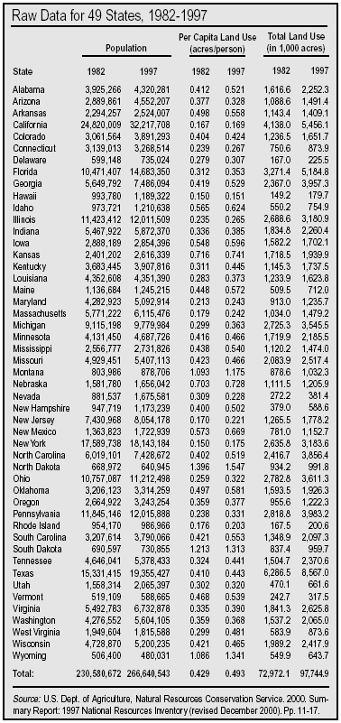
Appendix C
Percent Change in Land Development and Sprawl Factors for 49 states, 1982-1997
The "sprawl" in the 4th and 5th columns is the increase in the size of the contiguous developed area of each state from 1982 to 1997, as measured by the U.S. Department of Agriculture. The raw data used to calculate those changes and the ones in the 2nd and 3rd columns can be found in Appendix B. The "sprawl apportionment" in the 6th and 7th columns is the result of applying the "Holdren method" to the USDA data. That method is explained in Appendix E.
Read the following table like this (using the first line of Alabama as an example): From 1982 to 1997, the population of the state of Alabama grew by 10.1 percent while the average amount of urban land for each resident grew by 26.6 percent. These two factors combined to cause the urbanization of 635,700 acres of previously rural land. That sprawl amounted to a 39.3 percent increase (percent sprawl) in the total land developed in Alabama. When considering the two sprawl-inducing factors together, we find that 28.9 percent of the 635,700 acres of sprawl was related to population growth, while 71.1 percent was related to land-use factors that increased per capita land consumption.
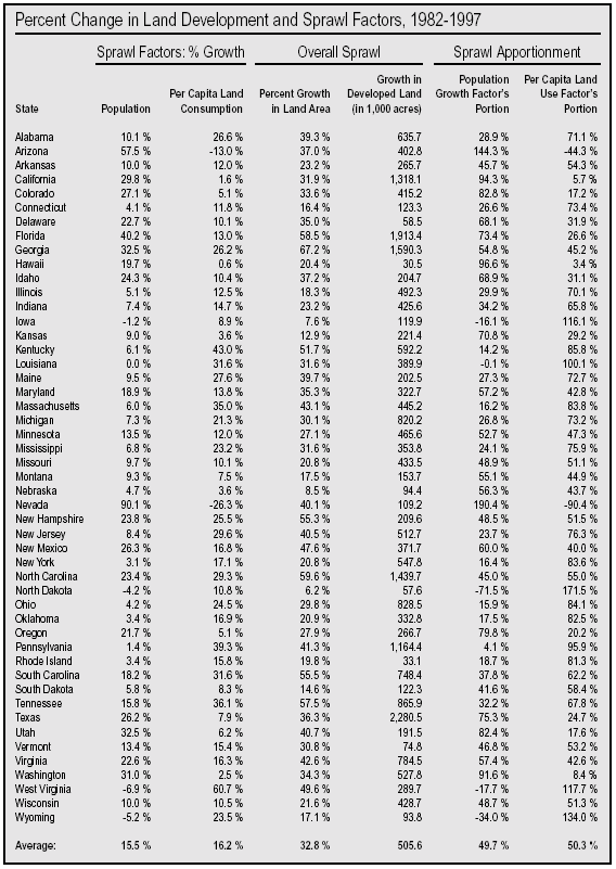
Appendix D
Calculating Per Capita Land Consumption
The per person land consumption in each state can be expressed as:
(1) a = A / P
where:
a = area of developed or urbanized land area for the average resident
A = Area of total developed or urbanized land in a state
P = Population of that state
For example, Minnesota in 1997 had 4,687,726 residents and about 2,185,500 developed acres. Thus, per capita developed land use for all purposes was around .466 acres (about a half an acre) per resident.
The land used per person is the total developed land area divided by the total number of people. This is the inverse of population density, which is the number of people per unit area of land. When per capita land consumption goes up, density goes down; when per capita land consumption goes down, density goes up.
The developed land area of the state can be expressed as:
(2) A = P x a
This can be stated as: the total developed square miles (or acres) of a state can be simply expressed or "factored" into the product of the Population of the state (viz., P) multiplied by the per capita urban land consumption (viz., a). This second equation (2) is the basis for attributing or apportioning the shares of sprawl (viz. growth in A) back onto two contributing factors, the growth in P and the growth in a.
Appendix E
The Holdren Apportioning Method
A method for quantifying the respective contributions of population growth and changes in consumption per capita of any type of resource consumption was laid out in a landmark 1991 paper by Harvard physicist Prof. John Holdren.208> Although Dr. Holdren's paper dealt specifically with the role of population growth in rising energy consumption, the method can be applied to many types of population/resource consumption analyses. In the case of sprawl, the resource under consideration is rural land, namely the expansion over time of the total acres of development in a state.
As stated in Appendix D, the total land area developed in a state can be expressed as:
(1) A = P x a
Where:
Following the logic in Holdren's paper, if over a period of time st (e.g., a year or decade), the population grows by an increment sP and the per capita land use changes by sa, the total urbanized land area grows by sA which is given by substituting in equation. (1):
(2) A + sA = (P + sP) x (a + sa)
Subtracting eqn. (1) from eqn. (2) and dividing through by A to compute the relative change (i.e., sA/A) in urbanized land area over time interval st yields:
(3) sA/A = sP/P + sa/a + (sP/P) x (sa/a)
Now equation (3) is quite general and makes no assumption about the growth model or time interval. On a year-to-year basis, the percentage increments in P and a are small (i.e., single digit percentages), so the second order term in equation (3) can be ignored. Hence following the Holdren paradigm, eqn. (3) states that the percentage growth in urbanized land area (viz., 100 percent x sA/A ) is the sum of the percentage growth in the population ( 100 percent x sP/P) plus the percentage growth in the per capita land use (100 percent x sa/a). Stated in words, equation (3) becomes:
(4) Overall percentage land area growth = Overall percentage population growth + Overall percentage per capita growth
In essence, the Holdren methodology quantifies population growth's share of total land consumption (sprawl) by finding the ratio of the overall percentage change in population over a period of time to the overall percentage change in land area consumed for the same period. This can be expressed as:
(5) Population share of growth =
The same form applies for per capita land use:
(6) Per cap. land use share of growth =
The above two equations follow the relationship based on Prof. Holdren's equation (5) in his 1991 paper. A common growth model follows the form (say for population):
(7) P(t) = P0 (1 + gP )t
Where P(t) is population at time t, P0 is the initial population and gP the growth rate over the interval. Solving for gP the growth rate yields:
(8) ln (1 + gP) = (1/t) ln (P(t)/P0)
Since ln (1 + x) approximately equals x for small values of x, equation (8) can be written as:
(9) gP = (1/t) ln (P(t)/P0).
The same form of derivation of growth rates can be written for land area (A) and per capita land use (a)
(10) gA = (1/t) ln (A(t)/A0)
(11) ga = (1/t) ln (a(t)/a0)
These three equations for the growth rates allow you to restate the Holdren result of equation (4) as:
(12) gP + ga = gA
Substituting the formulae (equations 9 through 11) for the growth rates and relating the initial and final values of the variables P, a and A over the period of interest into equation (12), the actual calculational relationship becomes:
(13) ln (final population / initial population) +
ln (final per capita land area / initial per capita land area) =
ln (final total land area / initial total land area)
In other words, the natural logarithm (ln) of the ratio of the final to initial population, plus the logarithm of the ratio of the final to initial per capita land area (i.e., land consumption per resident), equals the logarithm of the final to the initial total land area.
In the case of Minnesota from 1982 to 1997, this formula would appear as:
(14) ln (4,687,726 residents / 4,131,450 residents) +
ln (0.466 acre per resident / 0.416 acre per resident) =
ln (2,185,500 acres / 1,719,900 acres)
Computing the ratios yields:
(15) ln (1.134) + ln (1.120) = ln (1.270)
0.1258 + 0.1133 = 0.2390
Then applying equations (5) and (6), the percentage contributions of population growth and per capita land area growth are obtained by dividing (i.e., normalizing to 100 percent) each side by 0.250:
(16) 0.1258 + 0.1133 = 0.2390
0.2390 0.2390 0.2390
Performing these divisions yields:
(17) 0.53 + 0.47 = 1.0
Thus, we note that in the case of the Minnesota from 1982 to 1997, the share of sprawl due to population growth was 53 percent [100 percent x (0.1258 / 0.2390)], while declining density (i.e., an increase in land area per capita) accounted for 47 percent [100 percent x (0.1133 / 0.2390)]. Note that the sum of both percentages equals 100 percent.
Appendix F
About the Census Bureau's Urbanized Areas
Generally speaking, an Urbanized Area must exhibit a pattern of continuous development outward from a central core. Although there are special provisions for "jumps," and certain other exceptions, by and large, new areas added every 10 years by the Census Bureau to the adjacent urban fringe must be contiguous to that fringe and must have a population density of at least 1,000 people per square mile.
Population density can be determined by dividing the population of census tracts and blocks by their land area. In actuality, the Bureau does not ascertain what percentage of a given tract or block is paved or built upon; it is simply assumed to be "urbanized" if it has a population density of 1,000 per square mile. The Bureau allows exceptions to the density criterion when other criteria for "jumps," non-residential urban land use, closure of indentations and enclaves, and undevelopable territory are met.
Delineating Urbanized Areas is a large, labor-intensive endeavor. In order to more efficiently and accurately delineate Urbanized Areas in the 1990 census, the Census Bureau automated much of the task by using the TIGER (Topologically Integrated Geographic Encoding and Referencing) database and customized UA delineation software. In the near future, we will issue another study that analyzes the Urbanized Areas data that have only recently become available from the 2000 Census.
Difference from MSA Designation. Urbanized Areas are smaller in area than the Metropolitan Statistical Areas (MSA) that are mentioned far more commonly in the media and other public discussion. The Census Bureau describes an MSA as "a large population nucleus, together with adjacent communities having a high degree of social and economic integration with that core."209 The major difference between the Urbanized Area and the MSA is that the latter includes the entire land mass of every county that contains a part of a city and its suburbs. That means the outer parts of an MSA are rural. An Urbanized Area, on the other hand, includes whole counties only if every square mile of them is urbanized. And in the outer counties, only the land that is indeed urbanized is counted.
An MSA often lumps together cities that have substantially grown out toward each other but which may still contain some rural land between them. For example, Los Angeles and its contiguous suburbs in Orange and Los Angeles counties, Simi Valley and its suburbs, Oxnard-Ventura and their suburbs, and San Bernardino and Riverside and their suburbs are all classified as a single CMSA (Consolidated Metropolitan Statistical Area). But because there is some rural land remaining between the suburbs of one and the suburbs of another, these places are considered to be four separate Urbanized Areas.
Usefulness as a Measuring Tool. The 1,000-people-per-square-mile threshold for classification as part of an Urbanized Area is not without its critics. For example, urban expert David Rusk believes that the growth in Urbanized Land Areas since 1950, as documented in successive Census Bureau reports, understates the actual loss of rural environments to sprawl.
Yet for the purposes of this study, shortcomings of the Census designations have little effect on the outcome. Since this study has defined sprawl as the progressive loss of open space to built-up space unpaved lands to paved-over ground in other words the 1,000-per-square-mile criterion is as defensible a threshold between urban and rural zones as any. Moreover, it allows use of the Census Bureau's nationwide, unrivalled stock of information. The strength of the Census Bureau's uniform data set lies in calculating changes from rural to urban areas rather than in precisely defining the line that divides them. The shortcoming of the Census Bureau measurement is in calculating total development, not in calculating change. This study focuses on the change.
Endnotes
1 U.S. Census Bureau, "Largest Census-to-Census Population Increase in U.S. History as Every State Gains." April 2, 2001.
2 U.S. Census Bureau. March 2003. Revised Census Bureau Projection for 2050.
3 William Fulton, Rolf Pendall, Mai Nguyen, and Alicia Harrison. 2001. Who Sprawls Most? How Growth Patterns Differ Across the U.S. The Brookings Institution.
4 El Nasser, Haya and Paul Overberg. "What you don't know about sprawl. Controlling development a big concern, but analysis has unexpected findings" USA Today. February 22, 2001.
5 Fodor, Eben V. 1999. "Better Not Bigger: How to Take Control of Urban Growth and Improve Your Community." British Columbia: New Society.
6 Chen, Donald. "Study says Vegas has less sprawl than many big cities," by Launce Rake, Las Vegas Sun. October 17, 2002.
7 Community Development: Extent of Federal Influence on Urban Sprawl Is Unclear. April 30, 1999. www.gao.gov/archive/1999/rc99087.pdf
8 Quote from ZPG website article entitled "Sprawl is Bustin Out All Over." Retrieved 1 March 2000 at www.zpg.org/education/writingcontext/sprawlbustin.html
9 Sierra Club 2001 ballot question. See www.susps.org/sprawl/sb1_sbq.html.
10 L. Goodkin. 1974. When Real Estate and Home Building Become Big Business: Mergers, Acquisitions and Joint Ventures. Boston: Cahners Books. p. 14.
11 J. McMahan. 1976. Property Development: Effective Decision Making in Uncertain Times. New York: McGraw-Hill.
12 National Association of Home Builders. 1999. "Sierra Club Report Ignores Underlying Forces Behind Urban Growth." News release distributed on 5 October by PR Newswire. Remarks of Charles Ruma, president of the 200,000-member National Association of Home Builders.
13 Catherine Reagor. "Immigration will likely propel home building in next 30 years." The Arizona Republic. October 24, 1999.
14 Home Builders Association of Northern California. Green researchers show builders have curbed per capita land consumption. HBA News, July/August 2001. www.hbanc.org/news2000/JulAug2001/JulAug01feat1.html
15 Norman Myers and Julian L. Simon. 1994. Scarcity or Abundance? A Debate on the Environment. New York: W.W. Norton. This book is a transcript of a provocative debate held at Columbia University in October, 1992. The late Julian Simon entitled one of his chapters: "The Urban Sprawl and Soil Erosion Scam"; Randal OToole. 1999. "Report: Urban sprawl fears largely unfounded." Environment News, a project of the Heartland Institute. March; Environmental News Network. 1999. "Urban sprawl not a threat, report claims." Posted 16 March at www.cnn.com/NATURE/9903/31/sprawl.enn/index.htm
16 Gregg Easterbrook. 1995. A Moment on the Earth: The Coming Age of Environmental Optimism. New York: Viking. 745 pp. Quote from p. 434. On p. 435, Easterbrook adds "Because city dwellers have difficulty conceptualizing just how much undeveloped land America contains, they are prone to believe alarmist pronouncements about land loss." To his credit, Easterbrook acknowledges a short while later that, "But even in a country of American expanse, primal nature will not last unless society adapts [sic] a general vision of land preservation."
17 Stewart L. Udall. 1963, 1988. The Quiet Crisis and the Next Generation. Salt Lake City: Peregrine Smith Books.
18 U.S. Department of Agriculture, Natural Resources Conservation Service. 2000. Summary Report 1997 National Resources Inventory (revised December 2000). 84 pp. Released January 2001. See Table 1, "Surface area of nonfederal and federal land and water areas, by state and year," p. 11.
19 Karl Blankenship. 2000. "Bay partners split on policy for land conversion." Bay Journal. Vol. 10, No. 1.
20 Bank of America. 1996. "Beyond Sprawl: New Patterns of Growth to Fit the New California."
21 "Roads Affect 20% of U.S. Land" News release from the Society for Conservation Biology, 28 January 2000. The paper by Richard Forman of the Graduate School of Design at Harvard University appears in the February 2000 issue of Conservation Biology, published by the Society for Conservation Biology.
22 See note 18 above, Summary Report 1997 National Resources Inventory (revised December 2000), Table 2 "Land cover/use of nonfederal rural land, by state and year," p. 18, and Table 3 "Cropland use, by state and year," p. 25.
23 Vesterby, M. & Krupa, S. (2001). "Major Uses of Land in the United States, 1997." Resource Economics Division, Economic Research Service, USDA, Statistical Bulletin No. 973. October 18, 2001. www.ers.usda.gov/publications/sb973
24 U.S. Census Bureau, Midyear Population Estimates and Average Annual Period Growth Rates:1950 to 2050, International Data Base, October 2002 version.
25 David Pimentel and Mario Giampietro. 1994. "Food, Land, Population and the U.S. Economy." Washington, D.C.: Carrying Capacity Network; David Pimentel and Marcia Pimentel. 1997. "U.S. Food Production Threatened by Rapid Population Growth." Washington, D.C.: Carrying Capacity Network.
26 Dan Eggen. 1998. "A Growing Issue." The Washington Post. 28 October; Peter Pochna and Clarke Canfield. 1997. "State policies fostering suburban sprawl." Portland Press Herald Maine Sunday Telegram. 8 July; Jeffrey Spivak. 1999. "Kansas City looks at new alternative to suburban sprawl." Miami Herald. 9 May; Glenn Frankel and Peter Pae. 1997. "In Loudon, Two Worlds Collide." The Washington Post. 24 March, p. A1; Geneva Overholser. 1999. "Sentiment Against Sprawl Spreads." The Washington Post. 18 October; Rusty Hoover. 1999. "Public seeks to tame sprawl." The Detroit News. 4 April; R. Gregory Nokes. 1998. "Urban growth boundary shift stirs lobbyists." Portland Oregonian. 15 December; Justin Blum and Dan Eggen. 1999. "Sprawl Spreads to Legislative Races: Va. Campaigns Paint Foes as Supporting Uncontrolled Growth." The Washington Post. 27 May. p. B01.
27 "Straight Talk From Americans 2000." National Survey for the Pew Center for Civic Journalism, conducted by Princeton Survey Research Associates. February 15, 2000. www.pewcenter.org/doingcj/research/r_ST2000nat1.html
28 Molly OMeara. 1999. "The Worldwatch Report: U.S. Voters tell suburbia to slow down." Environmental News Network. www.enn.com/features/1999/07/071599/suburubia_4341.asp
29 Dominic Bonaiuto. 1999. "The sprawling growth debate." The Vienna (Va.) Times. 11 November. P. A1, A9.
30 Land Trust Alliance. 2001. "Voters Invest in Open Space 2000 Referenda Results." www.lta.org/publicpolicy/referenda2000.htm
31 Terry M. Neal. 1999. "Gore Seeks to Tap Voter Concern on Livability Issues." The Washington Post. May 5; Al Gore. 1998. "Remarks by Vice President Al Gore The Brookings Institution." The White House Office of the Vice President. 2 September. William Jefferson Clinton and Al Gore. 1999. "Remarks by the President and Vice President on Announcement of Lands Legacy Initiative." U.S. National Arboretum. 12 January; "Clinton-Gore Livability Agenda: Building Livable Communities for the 21st Century." Press release The White House, Office of the Vice President. 11 January; Michael Janofsky. 1999. "Gore Offers Plan to Control Suburban Sprawl." The New York Times. 12 January; Rob Gurwitt. 1999. "The war against sprawl, I."Salon Newsreal. www.salon1999.com/news/1999/01/21newsa.html
32 David Rusk. 1999. "Maryland's Smart Growth Popular but Untested." The New Regionalism: Planning Together to Reshape New Orleans Future, a special supplement in the New Orleans Times-Picayune. 8 September; "Solution to sprawl: Offer a good alternative." 1999. The Missoulian (Missoula, MT) 28 June.
33 Haya El Nasser. 1999. "Government's role in sprawl targeted: Policies might help encourage runaway growth." USA Today. 15 March.
35 Al Gore. 1998. Speech to Democratic Leadership Council Annual Conference on 2 December. Text of speech reprinted at website of the Center for New Urbanism at www.cnu.org/inthenews.html
36 Sierra Club. 1998. The Dark Side of the American Dream: The Costs and Consequences of Suburban Sprawl. Challenge to Sprawl Campaign, College Park, MD. www.tamalpais.sierraclub.org/transportation/sprawl/Sprawl_report.what.html.
37 American Farmland Trust. No date. "Competition for Land Project." www.farmland.org
38 Richard Moe. 1999. "The Sprawling of America Federal Policy Is Part of the Problem; Can It Be Part of the Solution?" 22 January address to the National Press Club, Washington, D.C.
39 David Goldberg. 1999. Covering Urban Sprawl: Rethinking the American Dream. Journalist's Resource Guide of the Radio-Television News Directors Association. p. 2.
40 Ironically, many of the graphics that accompany articles on sprawl, and are meant to illustrate it, show compact residential development, the very sort recommended by smart-growth proponents. This is probably because photographs of low-density, half-acre estates complete with lawns, gardens, and trees would appear too bucolic and attractive to convey the message of "paving over" the countryside.
41 Geneva Overholser. 1999. "Sentiment Against Sprawl Spreads." The Washington Post. 18 October.
42 Anon. 1997. "Focus on Sprawl and Biodiversity: Making the Connection." Biodiversity News. A Newsletter of The Biodiversity Project. Spring/Summer.
43 National Wildlife Federation. 2001. "Paving Paradise: Sprawl's Impact on Wildlife and Wild Places in California." A Smart Growth and Wildlife Campaign California White Paper. February.
44 Norman Myers, et al. 2000. "Biodiversity hotspots for conservation priorities." Nature, vol. 403, p.853. 24 February; R.P.Cincotta, et al. 2000. "Human population in the biodiversity hotspots." Nature, vol. 404 p. 990, 27 April. California is one of the world's 25 biodiversity hotspots and one of the most heavily populated ones at that.
45 Carolyn Lochhead. 1997. "Sprawl Threatens California Farmland Valleys at top of national list." San Francisco Chronicle. 20 March.
46 David Pimentel. 1997. "Rapid Population Growth in California: A Threat to Food Production and the Environment." Washington, D.C.: Carrying Capacity Network. 30 October.
47 David Pimentel. 1997. "Florida Agriculture Threatened by Population Growth." Washington, D.C.: Carrying Capacity Network. 30 October.
48 Mathis Wackernagel and William Rees. 1996. Our Ecological Footprint: Reducing Human Impact Upon the Earth. Philadelphia: New Society.
49 Mathis Wackernagel, Chad Monfreda, and Diana Deumling, 2002. Ecological Footprint of Nations, November 2002 Update. Redefining Progress. Sustainability Issue Brief. November.
50 "Problems Associated with Sprawl." No date. Planners Web: Planning Commissioners Journal. www.webcom.com/pcj/sprawl/sprawl4.html
51 North Carolina State University, Water Quality Group. No date. "Wetlands Loss and Degradation." h2osparc.wq.ncsu.edu/info/wetlands/wetloss.html
52 Chesapeake Bay Foundation. No date. "Growth, Sprawl, and the Bay." CBF Fact Sheet.
53 Dennis D. Murphy. 1988. "Challenges to Biological Diversity in Urban Areas." pp. 71-76 in Biodiversity (E.O. Wilson, ed.). Washington, D.C.: National Academy Press.; John Cairns, Jr. 1988. "Increasing Diversity by Restoring Damaged Ecosystems." pp. 333-343 in Biodiversity; Edward O. Wilson. 1999. The Diversity of Life (New Edition). New York: W.W. Norton.
54 South Carolina Ducks Unlimited. Undated. "ACE Basin: Haven for Songbirds." www.logicsouth.com/~scdu/aces9302.htm
55 Habitat fragmentation has contributed to a dramatic rise in the population of a native North American bird known as the brown-headed cowbird, which prefers edge and second growth habitats. Cowbirds are nest parasites, that is, they lay their eggs in the nests of more than 200 other species. Cowbird nestlings are larger and grow faster than the nestlings of the host species, which typically do not survive in an infested nest.
56 Terry L. Root and Larry McDaniel. 1995. "Winter Population Trends of Selected Songbirds." Pp. 21-23 in Our Living Resources: A Report to the Nation on the Distribution, Abundance, and Health of U.S. Plants, Animals, and Ecosystems. U.S. Department of the Interior, National Biological Service. Washington, D.C.: U.S. Government Printing Office; Partners in Flight/Aves de las Americas, Midwest Working Group. No date. "Conserving Migratory Songbirds of the Midwest." Brochure funded by U.S. Fish and Wildlife Service, Environmental Protection Agency, Aullwood Audubon Center and Farm.
57 Partners in Flight. 1993. "Birds of Two Worlds: Tropical birds of the Midwest." A brochure of the Midwest Neotropical Migratory Bird Conservation Program, with support by the Handley Corporation (St. Paul, MN), Mark Twain National Forest of the USDA Forest Service, Non-game Wildlife Program of the Minnesota Department of Natural Resources, Missouri Conservation Department, U.S. Fish and Wildlife Service, and University of Missouri.
58 Vermont Forum on Sprawl. No date. "Sprawl Defined." www.vtsprawl.org/sprawldef.htm The Vermont Forum on Sprawl is a project of the Orton Family Foundation; Solstice. No date. "Urban Sprawl." Solstice is an on-line source of sustainable energy information from Crest (Center for Renewable Energy and Sustainable Technology).
www.crest.org/efficiency/nrdc/mobility/sprawl.html
59 Gallup opinion surveys in USA Today, 31 December 1999.
60 Ibid.
61 Bank of America. 1996. "Beyond Sprawl: New Patterns of Growth to Fit the New California." Available on-line at www.rut.com/misc/beyondSprawl.html
62 Associated Press. 1999. "List of Most Congested Areas." 16 November.
63 Michael Cabanatuan. 1999. "Bay Area Ranked Among Worst in Nation: Study starts debate on cause, solutions." San Francisco Chronicle. 17 November.
64 David Gardiner, Assistant Administrator, United States Environmental Protection Agency. 1 April 1999 letter to David M. Walker, Comptroller General of the United States, General Accounting Office.
65 Joby Warrick. 2000. "Global Warming Is Real," Report Finds. The Washington Post. 13 January. Article describes a new report of an 11-member panel of the National Academy of Sciences, National Research Council.
66 World Resources Institute, United Nations Environment Programme, United Nations Development Programme, World Bank. 1996. World Resources 1996-97. New York: Oxford University Press. 365 pp.
67 Phillip P. Pan. 2001. "Scientists Issue Dire Prediction on Warming: Faster Climate Shift Portends Global Calamity this Century." The Washington Post. 23 January. pp. A1, A14.
68 National Assessment Synthesis Team. 2000. Climate Change Impacts on the United States: Overview of the Potential Consequences of Climate Variability and Change. US Global Change Research Program. New York: Cambridge University Press.
69 Council on Environmental Quality. 1997. Environmental Quality: 25th Anniversary Report. Washington, D.C.: U.S. Government Printing Office.
70 South Coast Air Quality Management District (SCAQMD). 1999. "Smog Levels." Last updated 5 November 1999. www.aqmd.gov/smog/; SCAQMD. No date; "Historic Ozone Air Quality Trends: Number of Basin-Days Exceeding health Standard Levels." www.aqmd.gov/smog/o3trend.html.
71 John and Mildred Teal. 1969. Life and Death of the Salt Marsh. New York: Ballantine; North Carolina State University, Water Quality Group. No date. "Values of Wetlands." h2osparc.wq.ncsu.edu/info/wetlands/wetloss.html
72 Nitrogen oxide emissions from vehicle tailpipes not only cause smog, but when they fall back to earth they can over-fertilize water bodies, since nitrogen is a primary nutrient needed for plant growth. While in general, aquatic plant growth is necessary and desirable for healthy aquatic ecosystems, over-fertilization can trigger growth in the wrong kinds of plants such as algae. These "algal blooms" are aesthetically displeasing as well as damaging to water quality and other aquatic organisms, like fish. It has been estimated that half of the nitrogen loadings that put stress on the Chesapeake Bay derive from this fallout.
73 Albert Bartlett. 1996. "The Mythology of Population Growth and the Economy." Interview with Nancy Pearlman in Focus, Vol. 6, No. 1. Washington, D.C.: Carrying Capacity Network.
74 Ibid. Bartlett states: "If you look at the data from the U.S. Census, they give figures for the annual per capita municipal taxes as a function of the size of the city. And so the taxes are a function of the size of the city the curve just goes steadily upward. The bigger the city, the bigger the per capita taxes." Albert Bartlett is Professor Emeritus of Physics at the University of Colorado at Boulder.
75 Eben Fodor. 1998. The Cost of Growth in Oregon: 1998 Report. Fodor & Associates, Eugene, Oregon, October.
76 Eben Fodor. 1997. Personal communication with Leon Kolankiewicz.
77 Carrying Capacity Network. 1998. Beyond Sprawl: The Cost of Population Growth to Local Communities. Washington, D.C. December.
78 Real Estate Research Corporation. 1974. The Cost of Sprawl. Prepared for the Council on Environmental Quality. Washington, D.C.: U.S. Government Printing Office.
79 Robert W. Burchell, David Listokin, William R. Dolphin. 1985. The New Practitioner's Guide to Fiscal Impact Analysis. Center for Urban Policy Research, Rutgers University, Princeton, NJ; Robert W. Burchell, David Listokin, William R. Dolphin. 1994. Development Impact Assessment Handbook. Washington, D.C.: Urban Land Institute; Robert W. Burchell. 1997. Fiscal Impacts of Alternative Land Development Patterns in Michigan: The Cost of Current Development Versus Compact Growth. Southeast Michigan Council of Governments. March; Robert W. Burchell et al. 1998. Cost of Sprawl Revisited: The Evidence of Sprawl's Negative and Positive Impacts. Washington, D.C.: National Transportation Research Board and National Research Council.
80 Phillip J. Longman. 1998. "Who pays for sprawl? Hidden subsidies fuel the growth of the suburban fringe." U.S. News & World Report. 27 April.
81 Bank of America, 1996. See note 20.
82 Maine State Planning Office. 1997. "The Cost of Sprawl." May.
www.state.me.us/spo
83 J. Dixon Esseks, Harvey E. Schmidt, and Kimberly L. Sullivan. 1999. Fiscal Costs and Public Safety Risks of Low-Density Residential Development on Farmland: Findings from Three Diverse Locations on the Urban Fringe of the Chicago Metro Area. Northern Illinois University, Departments of Public Administration and Political Science, for the American Farmland Trust. January.
84 Gabriel Dekel. 1997. "The Cost of Urban Sprawl: A Jurisdictional Context." Proceedings, American Planning Association Conference, San Diego 1997.
www.asu.edu/caed/proceedings/97/dekel.html
85 Rusk, 1999. See note 32.
86 DVera Cohn. 1999. "Urban Problems, Suburban Sprawl Linked." The Washington Post. 28 July.
87 Peter Behr. 1999. "Effort Urged to Stem Poverty, Sprawl in Area." The Washington Post. 29 July.
88 CNN. 1999. "Study: Fight urban sprawl, boost bottom line."
www.cnn.com/US/9906/16/urban.sprawl/
89 National Association of Local Government Environmental Professionals. 1999. Profiles of Business Leadership on Smart Growth: New Partnerships Demonstrate the Economic Benefits of Reducing Sprawl. 95 pp.
90 Bank of America, 1996. See note 20.
91 Goldberg, 1999. See note 39.
92 Texas Transportation Institute. 1999. Urban Mobility StudyI. mobility.tamu.edu/
93 James Howard Kuntsler. 1995. "How to Mess Up a Town." Planning Commissioners Journal. Winter.
94 James Howard Kuntsler. 1998. "Home From Nowhere." The Atlantic Monthly. September.
95 Maine State Planning Office, 1997. See note 82.
96 Goldberg, 1999. See note 39.
97 Goldberg, 1999. See note 39.
98 Robert Putnam. 1995. "Bowling Alone: America's Declining Social Capital." Journal of Democracy, 6(1): 65-78, January.
99 Julian Simon. 1980. "Resources, Population, Environment: An Over-supply of False Bad News." Science. 208, June 27, pp. 1431-1437. This was one of the first prominent publications to strongly assert the case that in general, the condition of natural resources was actually improving, in spite of (or because of) rising human populations, more powerful technology, and increasing affluence.
100 See, for example: Daniel T. Griswold. 2000. "FAIR Ads Unfairly Blame Immigrants for Urban Sprawl, Traffic Jams." CATO Today's Commentary, October 5. Distributed nationally on the Knight-Ridder news wire.
101 Gregg Easterbrook. 1999. "Suburban Myth: The case for sprawl." The New Republic. 15 March.
102 Robert W. Burchell et. al. 1998. Cost of Sprawl Revisited: The Evidence of Sprawl's Negative and Positive Impacts. Washington, D.C.: National Transportation Research Board and National Research Council.
103 United States General Accounting Office. 1999. Community Development: Extent of Federal Influence on "Urban Sprawl" Is Unclear. Report to Congressional Requesters. GAO/RCED-99-87. Issued April, 1999.
104 Ibid.
105 For example, a population density of 2,500 per square mile, corresponding to a moderate urbanized area density, is equal to almost four residents per acre (2,500 / 640 acres per square mile). The inverse of this land per resident or per capita land consumption is obtained by dividing one square mile by 2,500 residents (or dividing one acre by 3.9 residents) to obtain 0.004 square miles per resident, which equals 0.256 acre per resident.
106 Haya El Nasser. 1999. "Congressional sprawl study fails to find culprit." USA Today. 30 April.
107 Laurence C. Gerckens. 1994. "American Zoning and the Physical Isolation of Uses." Planning Commissioners Journal. Summer, Issue 15.
108 Barry Cullingworth. 1997. Planning in the USA: Policies, Issues and Processes. London and New York: Routledge. Quote from p. 56.
109 Gerckens, 1994. See note 107.
110 Kenneth T. Jackson. 1987. Crabgrass Frontier: The Suburbanization of the United States. New York: Oxford University Press.
111 National Association of Home Builders. 1999. "Consumer Survey on Growth Issues." April. Prepared for the Smart Growth Task Force by the NAHB Economics Department, Washington, D.C.
112 Karen DeWitt. 1994. "Minorities Now Lead Exodus From Inner Cities to Suburbs." The New York Times. Reprinted in Clearinghouse Bulletin (Vol. 4, No. 9), September/October 1994. Washington, D.C.: Carrying Capacity Network.
113 Ibid.
114 Geneva Overholser. 1999. "Sentiment Against Sprawl Spreads." The Washington Post. 18 October.
115 Jamie Trubia. 1998. "The United States in Comparison With Other Nations: Air Pollution Levels and Gasoline Taxes." Claremont Environmental Policy Briefs, Student Edition, December 1998. Roberts Environmental Center, Claremont McKenna College, Claremont, California.
116 Jenny B. Wahl. 1996. "Oil Slickers: How Petroleum Benefits at the Taxpayer's Expense." Institute for Local Self-Reliance. www.ilsr.org/carbo/costs/truecosts.html
117 National Association of Home Builders. No date. "NAHB's Statement of Policy on Smart Growth." www.nahb.org
118 U.S. Environmental Protection Agency. No date. "CERCLA Overview."
www.epa.gov/superfund/whatissf/cercla.htm
119 Vermont Forum on Sprawl. A Project of the Orton Family Foundation. "Sprawl Defined" http://www.vtsprawl.org/sprawldef.htm. Accessed 14 Nov. 1999.
120 General Motors advertisement in Life magazine, 1948; reprinted in David Goldberg. 1999. Covering Urban Sprawl: Rethinking the American Dream. Journalist's Resource Guide of the Radio-Television News Directors Association. p. 2.
121 National Association of Home Builders. 1999. See note 111. "Consumer Survey on Growth Issues." April. Prepared for the Smart Growth Task Force by the NAHB Economics Department, Washington, D.C. One possible source of bias in this survey was the fact that respondents differed from American averages in their dwelling patterns. Of the households responding to the survey 81 percent lived in a single family detached home, 5 percent in a single family attached home (i.e. condo or townhouse), 9 percent in an apartment in a multifamily building, and 4 percent in a mobile home. Nationally, the figures are 63 percent in single family detached units, 10 percent in attached units, 21 percent in apartments, and 6 percent in mobile homes. Given the fact that 19 percent more of the respondents in the survey lived in detached dwellings than the national average, one might expect them to express a higher preference for this type of home than the national average. Still, the results do suggest that many current apartment-dwellers would prefer to be living in houses or townhouses if they could afford it.
122 See Kenneth T. Jackson. 1987. Note 110.
123 Anon. No date. "The Roots of Sprawl: A Selected Review." Planning Commissioners Journal. www.plannersweb.com
124 Dwight David Eisenhower. 1963. Mandate for Change 1953-1956. New York: Doubleday. Quote from pp. 548-549.
125 Richard F. Weingroff. 1996. "Federal-Aid Highway Act of 1956: Creating the Interstate System." Public Roads. Vol. 60, No. 1, Summer. Magazine of the U.S. Federal Highway Administration. www.tfhrc.gov/pubrds/summer96/p96su10.htm.
126 Howard P. Wood. 1998. "How Government Highway Policy Encourages Sprawl." CATO This Just In. Washington, D.C.: The Cato Institute.
www.cato.org/dailys/8-18-98.html
127 Richard F. Weingroff. 1996. Note 125. See "The Edge City"sidebar.
128 Tamara Broberg. 1996. "Poetry of the Open Road." Public Roads. Vol. 60, No. 1, Summer. Magazine of the U.S. Federal Highway Administration. Available at www.tfhrc.gov
129 Kenneth T. Jackson. 1987. Note 110.
130 Laurence Gerckens. 1998. "Ten Events that Shaped the Twentieth Century American City." Planning Commissioners Journal. No. 30, Spring.
131 Christine Todd Whitman. 1998. Inaugural Address 20 January.
www.state.nj.us/inaug/inspeech4.html
132 U.S. Bureau of the Census. 1998. Statistical Abstract of the United States: 1998, Washington, D.C.: U.S. Government Printing Office, p. 61, Table 69.
133 Jon Gould. 1996. "The NIMBY Challenge." Real Change: Seattle's Homeless Newspaper. November; Mike Pruett. No date. "NIMBY Busting: Expedited Land Divisions Even the Playing Field." www.landscapeonline.com/lolpages/-editorial/0698LOL/9806NIMBY.htm; B.C. Ministry of Housing. No date. "BC Battles NIMBY." www.web.net/icurr/nimby.htm; Barry G. Rabe. 1994. Beyond NIMBY: Hazardous Waste Siting in Canada and the United States. Washington, D.C.: Brookings Institution Press.
134 Lisa Ross. 1996. "Viewpoint." San Diego Daily Transcript, 10 December.
135 University of Michigan School of Natural Resources and Environment. 1997. "Brief History of Environmental Justice." www-personal.umich.edu/~jrajzer/nre/history.html
136 U.S. Environmental Protection Agency, Office of Solid Waste and Emergency Response. 1998. "Environmental Justice" Home Page. www.epa.gov/swerosps/ej/index.html
137 Christopher H. Foreman, Jr. 1996. "A Winning Hand? The uncertain future of environmental justice." The Brookings Review. Vol. 14, No. 2, Spring. Washington, D.C.: The Brookings Institution.
138 Roberta Crowell Barbalace. No date. "Environmental Justice and the NIMBY Principle." www.klbproductions.com/yogi/hazmat/articles/nimby.html, the home page for Yogi's Behemoth: Chemistry, Environmental and Hazardous materials Transportation Resources.
139 Foreman, Jr., 1996. Note 137.
140 U.S. Census Bureau. 1990 CPH-1-1. 1990 Census of Population and Housing, Summary Population and Housing Characteristics; www.census.gov/population/www/estimates/nation2.html
142 Carrying Capacity Network. 1996. "U.S. Out of Step." Network Bulletin. Vol. 6, No. 2. March/April.
143 Frederick W. Hollman, Tammany J. Mulder, and Jeffrey E. Kallan. 2000. "Methodology and Assumptions for the Population Projections of the United States: 1999 to 2100. U.S. Census Bureau Population Division Working Paper No. 38. January 13. www.census.gov; D'Vera Cohn. 2000. "2100 Census Forecast: 2000 x 2; Minorities Expected to Account for 60 Percent of U.S. Population." The Washington Post. 13 January. A5. The Census Bureau's middle series contains those demographic scenarios and assumptions that are considered the most plausible.
144 Census Bureau. See Note 24.
145 National Center for Health Statistics. 1999. Birth/Natality figures, preliminary data 1998. www.cdc.gov/nchs/fastats/births.htm
146 Ed Lytwak. 1999. "A Tale of Two Futures: Changing Shares of U.S. Population Growth." NPG Forum Series. Washington, D.C.: Negative Population Growth.
147 Virginia Abernethy. 1997. "Critique of Warren's Approach to Calculating Immigration's Share of U.S. Population Growth." Focus, Vol. 7, No. 1. Washington, D.C.: Carrying Capacity Network.
148 See Hollman et al., note 143.
149 Results from the 2000 Census released by the Census Bureau show that there were 13.2 million immigrants in the 2000 Census who indicated that they arrived between 1990 and 2000. Analysis of this kind is possible because persons are asked if they are foreign-born and if so, what year did they come to live in the United States. The 13.2 million figure does not include persons who entered during the 1990s and returned home or died before 2000. Thus the number of new immigrants during the decade must have been significantly larger than 13 million. The 1.5 million figure for the end of the 1990s is based on the authors analysis of the Census 2000 Supplemental Survey and the reweighted 2000 Current Population Survey. Both surveys include legal and illegal immigrants and show that in 1998 and 1999 1.5 million immigrants entered the country. The 1.5 million figure is also supported by estimates of the illegal alien population prepared in January of 2003 by the Immigration and Nationalization Service (INS), which showed that the illegal alien population grew by 500,000 in 1999. See Table C of the INS report for the estimated net increase in the illegal alien population by year.
www.immigration.gov/graphics/shared/aboutus/statistics/Illegals.htm
150 Lytwak, 1999. Note 146.
151 U.S. Census Bureau. 1998. "Population Profile of the United States: 1997." Current Population Reports, Series P20-499. Washington, D.C.: U.S. Government Printing Office. p. 9.
152 Lytwak, 1999. Note 146.
153 Amara Bachu. 1997. "Fertility of American Women: June 1995. U.S. Census Bureau, Current Population Reports, Series P20-499. Washington, D.C.: U.S. Government Printing Office.
154 See note 145. The reason for the discrepancy between the percentage of births due to immigrants and the percentage of natural increase is their younger age structure; therefore a smaller percentage of immigrants are dying.
155 Steven A. Camarota. Immigrants in the United States 2002. A Snapshot of America's Foreign-Born Population. The Center for Immigration Studies. November 2002. www.cis.org/sites/cis.org/files/articles/2002/back1302.html
156 Poster Project for a Sustainable U.S. Environment. 1998. Based on Census Bureau data.
157 William H. Frey. 1995. "Immigration and Internal Migration Flight from U.S. Metropolitan Areas: Toward a New Demographic Balkanization." Urban Studies. Vol. 32, No. 4-5, pp. 733-757; William H. Frey. 1996. "Immigration, Internal Out-Movement, and Demographic Balkanization in America: New Evidence for the 1990s." University of Michigan, Population Studies Center Research Report No. 96-364. April.
158 Parris Glendening. 1998. "Conference Remarks." ECOS/AASHTO Conference on Smart Growth. 1 December.
159 Urban Land Institute website at www.uli.org
160 Smart Growth Network. 2000. "About Smart Growth."
www.smartgrowth.org/information/aboutsg.html Text from executive summary of Why Smart Growth: A Primer by International City/County Management Association with Geoff Anderson, 7/98. Website maintained by the Sustainable Communities Network.
161 David Bollier. 1999. How Smart Growth Can Stop Sprawl. Washington, D.C.: Sprawl Watch Clearinghouse.
162 Edward T. McMahon. 1997. "Stopping Sprawl by Growing Smarter." Planning Commissioners Journal. Issue 26, Spring.
163 Mary P. English, Jean H. Peretz, and Melissa Mandershield. 1999. Smart Growth for Tennessee Towns & Cities: A Process Guide. Chapter 1, "What is Smart Growth?" Knoxville, TN: Waste Management Research and Education Institute. eerc.ra.utk.edu/smart/title.htm
164 Judith Corbett and Joe Velasquez. 1994. "The Ahwahnee Principles: toward more livable communities." Western City Magazine. September.
www.lgc.org/clc/library/articles/archives/ahwahnee_article.html
165 Richard Lacayo. 1999. "The Brawl over Sprawl." Time. 22 March.
166 Ibid.
167 Steven Fader. 2000. Density By Design: New Directions in Residential Development. Urban Land Institute.
168 National Association of Home Builders. No date. "NAHB's Statement of Policy on Smart Growth. www.nahb.org/main_features/smartpolicy.html
169 Ibid.
170 Ibid.
171 See for example: Competitive Enterprise Institute. 1999. "Fact and Fiction on Smart Growth and Urban Sprawl." 19 April press release; available on the World Wide Web at the CEI website, www.cei.org/Preader.asp?ID=669; John A. Charles. 1998. "The Dark Side of Growth Controls: Some Lessons from Oregon." Arizona Issues Analysis, No. 150, May. The Goldwater Institute; Peter Gordon and Harry W. Richardson. 2000. "Critiquing Sprawl's Critics." The Cato Institute. www.cato.org/pubs/pas/policyanalysis.html
172 Lacayo, 1999. Note 165.
174 USDA Natural Resources Conservation Service. 2000. Summary Report 1997 National Resources Inventory (revised December 2000). 84 pp. Prepared in collaboration with the Iowa State University Statistical Laboratory.
175 The NRI is based on scientifically-selected sample sites in 49 states. The sample constitutes a two-stage, stratified area sample of the entire country, with 800,000 sample points representing each county of every state except Alaska. Photo-interpretation and remote sensing were utilized extensively. Since 1982, the NRCS has conducted an NRI every five years under the same procedures and protocols, so that nationally-consistent databases are available for 1982, 1987, 1992, and 1997. (Although the next survey was conducted in 2002, the results will not be available for at least another year or two.) Analysts can be confident that variations in land figures between different inventories reflect differences "on the ground" rather than in sampling methods. Nevertheless, as in all statistical samples, there are margins of error.
176 The U.S. Census Bureau data sources used in this study are: 1990 Census of Population and Housing, Summary Population and Housing Characteristics United States, Table 8 Land Area and Population Density; 1980 Census of Population, Number of Inhabitants, United States Summary, Table 34 Population, Land Area, and Population Density of Urbanized Areas: 1980; 1970 Census of Population, Volume 1 Characteristics of the Population, Part 1, United States Summary (issued June 1973), Table 20 Population and Land Area of Urbanized Areas: 1970 and 1960. All of these are available from the Statistical Information Office (Population Division) of the U.S. Department of Commerce's Bureau of the Census in Maryland (301-457-2422).
177 U.S. Census Bureau. No Date. Chapter 12. "The Urban and Rural Classifications."
178 West Virginia is a special case for two reasons: First, the topography of the "mountain state" is such that a great deal of land often has to be leveled for even modest development or resource extraction projects like "mountain-top removal" surface coal mining. Second, West Virginia has seen an increase in vacation home construction and tourism-related development as a consequence of its natural beauty, low land prices, and proximity to the rapidly growing and affluent Washington, D.C. metropolitan area and to a lesser extent the Pittsburgh metropolitan area. The building of vacation or second homes and tourist facilities is unusual because land is cleared for housing and the infrastructure necessary to support it, but there is little or no corresponding increase in population because the Census continues to count persons as living at their primary place of residence out-of-state.
179 John P. Holdren. 1991. "Population and the Energy Problem." Population and Environment, Vol. 12, No. 3, Spring 1991. Holdren is Teresa and John Heinz Professor of Environmental Policy and Director of the Program on Science, Technology, and Public Policy at Harvard University's Kennedy School of Government, as well as Professor of Environmental Science and Public Policy in the Department of Earth and Planetary Sciences at Harvard University. Trained in aeronautics/astronautics and plasma physics at MIT and Stanford, he previously co-founded and co-led for 23 years the campus-wide interdisciplinary graduate degree program in energy and resources at the University of California, Berkeley. In 2000, he was awarded the Tyler Prize for Environmental Achievement at the University of Southern California, which administers the award. The Tyler Prize is the premier international award honoring achievements in environmental science, energy, and medical discoveries of worldwide importance.
180 President's Council on Sustainable Development. 1996. Sustainable America: A New Consensus. Washington, D.C.: U.S. Government Printing Office. From p. 12.
181 Even after the 1996 welfare reforms, which curtailed eligibility for some immigrants, immigrant welfare use remains higher than that of natives for all four major programs and for all entering cohorts after 1970. Steven Camarota, Immigrants in the United States 2000. Center for Immigration Studies, January, 2001.
182 Eben Fodor. 2002. Assessment of Statewide Growth Subsidies in Oregon. Alternatives to Growth Oregon. www.agoregon.org/pdf/Subsidies_Report.pdf
183 2001 Metro Public Opinion Study by Davis and Hibbitts Inc., May, 2001. When asked who should pay the cost of growth, 40 percent felt developers and new home buyers should pay all of the costs associated with infrastructure, 33 percent felt new growth should pay a greater share, and 21 percent felt that the costs should be equally shared (6 percent don't know), as cited in Fodor, 2002.
184 Ed Lytwak. 1999. "A Tale of Two Futures: Changing Shares of U.S. Population Growth." NPG Forum Series. Washington, D.C.: Negative Population Growth.
185 Amara Bachu. 1997. "Fertility of American Women: June 1995. U.S. Census Bureau, Current Population Reports, Series P20-499. Washington, D.C.: U.S. Government Printing Office.
186 Short-term population growth, especially covering the next couple of decades, can be heavily influenced by the "population momentum" of previous growth. For example, even though native fertility has been below replacement level since 1972, it still will provide several millions more population growth over the next couple of decades because of population momentum from the high fertility of the 1950s and 1960s. Essentially, the grand-daughters of the girls born during the Baby Boom of the 1950s and 1960s will need to age out of child-bearing years before that earlier Baby Boom stops producing population growth. Thus, native fertility is a significant although not major cause of "short-term population growth" in the U.S. But "long-term population growth" (three decades or more down the line) will include virtually no growth resulting from the native fertility of today. The population momentum of the above-replacement-level fertility before 1972 will have run out. Virtually all population growth over the "long-term" will be the result of post-1970 immigration and high immigrant fertility.
187 Ibid.
188 U.S. Census Bureau. 1998Current Population Survey. March. Of immigrants who arrived in the 1990s, 44 percent lived in central cities. That compares to 23 percent for natives. But it also means that 56 percent of new immigrants lived outside central cities.
189 Mark Engebretson. 2000. "Suburbia Goes Global: Cultures collide outside the city limits." Utne Reader. July 8, 2000.
190 Robert D. Manning and Anita C. Butera. 1997. "From City to Suburbs: The New Immigration, Native Minorities, and the Post-Industrial Metropolis." The Annals of the International Institute of Sociology. Vol. 6, pp. 67-100.
191 Ibid.
192 "Even with jobs in suburbs, commutes get longer." Christian Science Monitor, March 7, 2003.
193 John Johnson. February 4, 2002. "Crowded Living In California's Open Spaces" Los Angeles Times.
194 Census Bureau, 1998. Note 150.
195 According to the National Center for Health Statistics, the TFR of non-Hispanic white females was 1.8 in 1997 (compared to 2.1 for replacement level). Using Census Bureau data, it can be calculated that in 1970, non-Hispanic whites comprised 83 percent of the U.S. population and accounted for approximately 78 percent of the births. By 1994, non-Hispanic whites comprised 74 percent of the population and accounted for 60 percent of the births. With immigration included (approximately 90 percent of which originates from non-European sources), the non-Hispanic white share of current population growth drops well below 50 percent. According to medium projections of the Census Bureau and the National Research Council of the National Academy of Sciences, non-Hispanic whites will account for 6 percent of the nation's population growth between 1995 and 2050, blacks for 18 percent, Asians for 20 percent, and Hispanics for 54 percent (James P. Smith and Barry Edmonston, eds. 1997. The New Americans: Economic, Demographic, and Fiscal Effects of Immigration. Washington, D.C.: National Academy Press. Table 3.7). By 2050, Non-Hispanic whites are projected to have declined to 51 percent of the U.S. population from 87 percent in 1950 (Table 3.10, The New Americans).
196 "The Impact of New Americans: A Review and Analysis of the National Research Council's The New Americans: Economic, Demographic, and Fiscal Effects of Immigration" by Steven A. Camarota and Leon Bouvier , Table 6. December 1999.
www.cis.org/sites/cis.org/files/articles/1999/combinednrc.pdf
197 Figures are based on the authors analysis of the March 1998 Current Population Survey collected by the Census Bureau. Figures for the children of immigrants are for all person born in the United States who have reported in the Survey that their mother was born in another country.
198 The 2000 Census showed that over 80 percent of immigrants that entered in the 1990s came from under-developed countries from Latin America, Asia, and Africa.
199 Roy Beck and Leon Kolankiewicz. 2001. "Weighing Sprawl Factors in Large U.S. Cities." NumbersUSA.com.
200 William H. Frey. 1995. "Immigration and Internal Migration Flight from U.S. Metropolitan Areas: Toward a New Demographic Balkanization." Urban Studies. Vol. 32, No. 4-5, pp. 733-757.
201 Robert J. Jagiello. 1992. California in Chaos: A Survival Manual. Tomorrow Books.
202 Jonathan Tilove and Joe Hallinan. 1994. "Whites Flee Immigrants for Whiter States." Newhouse News Service.
203 Thomas J. Sugrue. 2003. Suburbanization and African Americans. Africana.com: The Gateway to the Black World. www.africana.com/Articles/tt_983.htm
204 Karen De Witt. 1994. "Minorities Now Lead Exodus From Inner Cities to Suburbs." The New York Times, 15 August.
205 Michael A. Fletcher. 1998. "In L.A. a Sense of Future Conflicts." The Washington Post. P. A1, April 7.
206 Anon. Urban Guide: Growth Patterns from 1980 to 1990.muspin.gsfc.nasa.gov/Prime/art4txt.html Minority University Space Interdisciplinary Network NASA. No date.
207 Glenn Fuguitt, John Fulton, and Calvin Beale. 2001. The Shifting Pattern of Black Migration From and Into the Nonmetropolitan South, 1965-1995. Economic Research Service, U.S. Department of Agriculture. ERS RDRR No. RDRR93. , December 2001. www.ers.usda.gov/publications/rdrr93/
<208 John P. Holdren. 1991. "Population and the Energy Problem." Population and Environment, Vol. 12, No. 3, Spring 1991. Holdren is Teresa and John Heinz Professor of Environmental Policy and Director of the Program on Science, Technology, and Public Policy at Harvard University's Kennedy School of Government, as well as Professor of Environmental Science and Public Policy in the Department of Earth and Planetary Sciences at Harvard University. Trained in aeronautics/astronautics and plasma physics at MIT and Stanford, he previously co-founded and co-led for 23 years the campus-wide interdisciplinary graduate degree program in energy and resources at the University of California, Berkeley. In 2000, he was awarded the Tyler Prize for Environmental Achievement at the University of Southern California, which administers the award. The Tyler Prize is the premier international award honoring achievements in environmental science, energy, and medical discoveries of worldwide importance.
<209 www.census.gov/population/www/estimates/metroareas.html
<210 David Rusk. 1999. Letter to Ms. Georgia Masters, Department of Community Economic Development, State of Pennsylvania, Harrisburg. July 12. Rusk is an independent consultant on urban and suburban policy, the author of Cities without Suburbs, and the former mayor of Albuquerque, New Mexico.
About the Authors
Roy Beck is director of the NumbersUSA Education and Research Foundation, an Internet organization that tracks the role of each member of Congress in forcing or reducing U.S. population growth. He also runs SprawlCity.org, a website about consumption growth and population growth and their roles in urban sprawl. A graduate of the University of Missouri School of Journalism, he won national awards during the 1970s for his coverage of urban expansion issues, including honors from the U.S. Environmental Protection Agency and the Izaak Walton League. A former Washington correspondent for a daily newspaper chain, he is the author of four public policy books. His articles have appeared in scores of publications, including the Atlantic Monthly. Mr. Beck has lectured widely on the ethical aspects of U.S. population issues.
Leon Kolankiewicz is an environmental scientist and national natural resources planner. He has a B.S. in forestry and wildlife management from Virginia Tech and an M.S. in environmental planning and natural resources management from the University of British Columbia. His professional experience includes stints with the U.S. Fish and Wildlife Service, National Marine Fisheries Service, Alaska Department of Environmental Conservation, Alaska Department of Fish and Game, University of Washington, University of New Mexico, and as an environmental planner with the Orange County, (Ca.) Environmental Management Agency. Mr. Kolankiewicz is the author of Where Salmon Come to Die: An Autumn on Alaska's Raincoast.
Steven A. Camarota is Director of Research at the Center for Immigration Studies in Washington, D.C. He holds a master's degree in political science from the University of Pennsylvania and a Ph.D. in public policy analysis from the University of Virginia. Dr. Camarota often testifies before Congress and has published widely on the political and economic effects of immigration on the United States. His articles on the impact of immigration have appeared in both academic publications and the popular press including Social Science Quarterly, The Washington Post, The Chicago Tribune, Campaigns and Elections, and The Public Interest. Dr. Camarota's most recent studies published by the Center for Immigration Studies are Back Where We Started: An Examination of Trends in Immigrant Welfare Use Since Welfare Reform, and The Open Door: How Militant Islamic Terrorists Entered and Remained in the United States, 1993-2001.
Anne Manetas was the Project Coordinator of this study. She is the Director of Environmental Projects for NumbersUSA Education & Research Foundation.